Skip to search
Skip to main content
Skip to first result
Search
You Searched For
%22Austria--Maps%22
Format
cartographic
New Search
Search Results
Published / Created:
1918
Call Number:
11hc 1918-Z12
Container / Volume:
BRBL_00010G
Image Count:
2
Resource Type:
Maps , Atlases & Globes
Alternative Title:
La Malmaison
Description:
On verso: Map with "Bl.22 .La Malmaison
Publisher:
s.n.,
Subject (Geographic):
France--Maps
Found in:
Beinecke Rare Book and Manuscript Library > Clermont-Noyon.
Call Number:
402 M59 1630
Container / Volume:
BRBL_00233A
Image Count:
2
Resource Type:
Maps , Atlases & Globes
Description:
Signature R, page number 22 on verso.
Subject (Geographic):
Milan (Italy : Province)--Maps --Early
Found in:
Beinecke Rare Book and Manuscript Library > Stato di Milano.
Creator:
Published / Created:
1739
Call Number:
1996 +91
Image Count:
3
Resource Type:
Books, Journals & Pamphlets
Description:
Frontispiece map , 25 x 41 cm.
Publisher:
Printed for Messrs. Bettesworth and Hitch; J. Clarke; S. Birt; Tho. Wotton, and J. Shuckburgh; and T. Osborne,
Subject (Geographic):
Madras (India)--Maps --Early works to
Subject (Name):
Aurangzeb, Emperor of Hindustan, 1618-1707 --Portraits
Subject (Topic):
Geography--Early works to 1800
Found in:
Beinecke Rare Book and Manuscript Library > Modern history: or, The present state of all nations. Describing their respective situations, persons, habits, ... animals and minerals. ... By Mr. Salmon. Illustrated with cuts and maps ... by Herman Moll ...
Creator:
Published / Created:
1595
Call Number:
Pequot +L65
Collection Title:
Nauigatio ac itinerarium Iohannis Hugonis Linscotani in Orientalem siue Lusitanorum Indiam
Image Count:
1
Description:
Bound in following page 22 .
Subject (Geographic):
Borneo --Maps
Subject (Name):
Claesz, Cornelis, ca. 1546-1609, publisher, Elzevier, Gillis, bookseller, and Hendricksz, Aelbrecht, fl. 1573-1605, printer
Subject (Topic):
Voyages and travels --Early works to 1800
Collection Created:
Hagae-Comitis : Ex officina Alberti Henrici, impensis authoris & Cornelii Nicolai, prostantque apud Aegidium Elseuirum, anno 1599
Found in:
Beinecke Rare Book and Manuscript Library > Exacta & accurata delineatio cum orarum maritimarum tum etiam locorum terrestrium quae in regionibus China, Cauchinchina, Camboia sive Champa, Syao, Malacca, Arracamn & Pegu ...
Creator:
Published / Created:
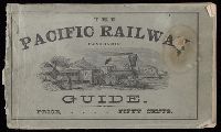
c1870.
Call Number:
Zc10 870hac
Image Count:
67
Alternative Title:
The Pacific panoramic guide.
Description:
Maps have 6 panels and are bound in at
Publisher:
Horton & Leonard, Printers]
Subject (Geographic):
Salt Lake City (Utah) --Description and travel, West (U.S.) --Description and travel, and West (U.S.) --Guidebooks
Subject (Name):
Union Pacific Railroad Company
Subject (Topic):
Railroads--Maps
Found in:
Beinecke Rare Book and Manuscript Library > The traveler's own book, a panorama of overland travel, from Chicago to San Francisco via the great and attractive route, Chicago Burlington & Quincy R.R. ... Burlington & Missouri River R.R. ... Union Pacific Railroad ... Utah Central Railroad ... Central Pacific Railroad ... Western Pacific Railroad ... containing complete traveler's maps ... By Alfred A. Hart.
Creator:
Published / Created:
1789 June 1
Call Number:
1982 Folio 10
Image Count:
1
Description:
No. 22 of 43 maps bound together in
Publisher:
W. Faden
Subject (Geographic):
Germany --Maps --Early works to 1800
Subject (Name):
Brunswick-Luneburg, House of
Found in:
Beinecke Rare Book and Manuscript Library > A new map of the King of Great Britain's dominions in Germany or the electorate of Brunswick-Luneburg and its dependencies
Creator:
Published / Created:
[1730?]
Call Number:
755 1730
Container / Volume:
BRBL_00426
Image Count:
1
Resource Type:
Maps , Atlases & Globes
Description:
Bar scale given in "echelle de cent lieues Francoises"., Copy 3: Sh, Includes notes., Inset: Carte particuliere des embouchures de la riviere S. Louis et de la Mobile. Scale [ca. 1:2,700,000]., Relief shown pictorially., and Shows some explorers' routes.
Publisher:
Chez Jean Cóvens et Corneille Mortier, geographes,
Subject (Geographic):
Louisiana--Maps --Early works to 1800
Subject (Name):
Cóvens et Mortier. Atlas nouveau and Le Maire, François
Found in:
Beinecke Rare Book and Manuscript Library > Carte de la Louisiane et du cours du Mississipi / dressée sur un grand nombre de memoires entr'autres sur ceux de Mr. le Maire, par Guillme. de L'Isle de l'Academie Rle. des Sciences.
Creator:
Published / Created:
[1730?]
Call Number:
755 1730
Container / Volume:
BRBL_00426
Image Count:
1
Resource Type:
Maps , Atlases & Globes
Description:
Appears in the Cóvens et Mortier's Atlas nouveau, 1730 and later eds., Bar scale given in "echelle de cent lieues Francoises"., Copy 2: With watermark. Sheet measures 54.6 x 63.4 cm., and Inset: Carte particuliere des embouchures de la riviere S. Louis et de la
Publisher:
Chez Jean Cóvens et Corneille Mortier, geographes,
Subject (Geographic):
Louisiana--Maps --Early works to 1800
Subject (Name):
Cóvens et Mortier. Atlas nouveau and Le Maire, François
Found in:
Beinecke Rare Book and Manuscript Library > Carte de la Louisiane et du cours du Mississipi / dressée sur un grand nombre de memoires entr'autres sur ceux de Mr. le Maire, par Guillme. de L'Isle de l'Academie Rle. des Sciences.
Creator:
Published / Created:
[1730?]
Call Number:
755 1730
Container / Volume:
BRBL_00426
Image Count:
1
Resource Type:
Maps , Atlases & Globes
Description:
Appears in the Cóvens et Mortier's Atlas nouveau, 1730 and later eds., Bar scale given in "echelle de cent lieues Francoises"., Copy 1: Bookseller's label: Libreria Loescher e Co. ... Roma. Mounted on linen. Sheet measures 56.5 x 65.8 cm., and Covers eastern Un
Publisher:
Chez Jean Cóvens et Corneille Mortier, geographes,
Subject (Geographic):
Louisiana--Maps --Early works to 1800
Subject (Name):
Cóvens et Mortier. Atlas nouveau and Le Maire, François
Found in:
Beinecke Rare Book and Manuscript Library > Carte de la Louisiane et du cours du Mississipi / dressée sur un grand nombre de memoires entr'autres sur ceux de Mr. le Maire, par Guillme. de L'Isle de l'Academie Rle. des Sciences.
Creator:
Published / Created:
[1706?]
Call Number:
1973 Folio 10
Image Count:
1
Resource Type:
Maps , Atlases & Globes
Description:
No. 22 of 69 maps bound together in
Publisher:
[Frederik de Wit]
Subject (Geographic):
Italy, Southern --Maps --Early works to
Found in:
Beinecke Rare Book and Manuscript Library > Regnum Neapolis: in quo sunt Aprutium ulterius et citerius, Comitatus Molisius, Terra Laboris, Capitaniata Principatus ulterior et citerior, Terra Bariensis et Hidruntina, Basilicata, Calabria citerior et ulterior
Branch:v1.61.8 ,Deployed:2024-06-20T11:15:15-04:00