Skip to search
Skip to main content
Skip to first result
Search
You Searched For
%22Austria--Maps%22
Resource Type
Maps, Atlases & Globes
New Search
Search Results
Creator:
Published / Created:
[1730?]
Call Number:
755 1730
Container / Volume:
BRBL_00426
Image Count:
1
Resource Type:
Maps , Atlases & Globes
Description:
Appears in the Cóvens et Mortier's Atlas nouveau, 1730 and later eds., Bar scale given in "echelle de cent lieues Francoises"., Copy 2: With watermark. Sheet measures 54.6 x 63.4 cm., and Inset: Carte particuliere des embouchures de la riviere S. Louis et de la
Publisher:
Chez Jean Cóvens et Corneille Mortier, geographes,
Subject (Geographic):
Louisiana--Maps --Early works to 1800
Subject (Name):
Cóvens et Mortier. Atlas nouveau and Le Maire, François
Found in:
Beinecke Rare Book and Manuscript Library > Carte de la Louisiane et du cours du Mississipi / dressée sur un grand nombre de memoires entr'autres sur ceux de Mr. le Maire, par Guillme. de L'Isle de l'Academie Rle. des Sciences.
Creator:
Published / Created:
[1730?]
Call Number:
755 1730
Container / Volume:
BRBL_00426
Image Count:
1
Resource Type:
Maps , Atlases & Globes
Description:
Appears in the Cóvens et Mortier's Atlas nouveau, 1730 and later eds., Bar scale given in "echelle de cent lieues Francoises"., Copy 1: Bookseller's label: Libreria Loescher e Co. ... Roma. Mounted on linen. Sheet measures 56.5 x 65.8 cm., and Covers eastern Un
Publisher:
Chez Jean Cóvens et Corneille Mortier, geographes,
Subject (Geographic):
Louisiana--Maps --Early works to 1800
Subject (Name):
Cóvens et Mortier. Atlas nouveau and Le Maire, François
Found in:
Beinecke Rare Book and Manuscript Library > Carte de la Louisiane et du cours du Mississipi / dressée sur un grand nombre de memoires entr'autres sur ceux de Mr. le Maire, par Guillme. de L'Isle de l'Academie Rle. des Sciences.
Creator:
Published / Created:
[1706?]
Call Number:
1973 Folio 10
Image Count:
1
Resource Type:
Maps , Atlases & Globes
Description:
No. 22 of 69 maps bound together in
Publisher:
[Frederik de Wit]
Subject (Geographic):
Italy, Southern --Maps --Early works to
Found in:
Beinecke Rare Book and Manuscript Library > Regnum Neapolis: in quo sunt Aprutium ulterius et citerius, Comitatus Molisius, Terra Laboris, Capitaniata Principatus ulterior et citerior, Terra Bariensis et Hidruntina, Basilicata, Calabria citerior et ulterior
Creator:
Map Company
Published / Created:
August, 1923.
Call Number:
776 B764 1923
Container / Volume:
BRBL_00502
Image Count:
4
Resource Type:
Maps , Atlases & Globes
Abstract:
Fire insurance map , colored to show
Alternative Title:
Aug. 1923, Bridgeville, Del. and Bridgeville, Del.
Description:
Coordinates not present on map and are
Publisher:
Sanborn Map Company,
Subject (Geographic):
Bridgeville (Del.)--Maps .
Subject (Topic):
--Bridgeville--Maps .
Found in:
Beinecke Rare Book and Manuscript Library > Bridgeville, Sussex County, Delaware.
Creator:
Published / Created:
1777
Call Number:
73 1777
Container / Volume:
BRBL_00373
Image Count:
1
Resource Type:
Maps , Atlases & Globes
Alternative Title:
[American maps ; v. 3, no. 22 ]
Description:
Relief shown pictorially and by hachures. and Shows the Canadian-United States border from Lake Ontario along the St. Lawrence River to 45₋p0₋s N. latitude, east to the Connecticut River, and northeast along the "Height of the land." Coverage of areas away fr
Subject (Geographic):
Canada--Boundaries--United States--Maps
Subject (Name):
Sauthier, Claude Joseph
Found in:
Beinecke Rare Book and Manuscript Library > A map of the inhabited part of Canada from the French surveys, with the frontiers of New York and New England; from the large survey by Claude Joseph Sauthier. Engraved by Wm. Faden, 1777.
Creator:
Map Company, issuing body
Published / Created:
1922
Call Number:
766 F16 1922
Image Count:
22
Resource Type:
Maps , Atlases & Globes
Abstract:
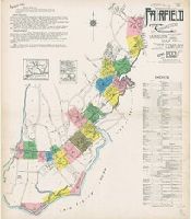
Sanborn fire insurance maps are a rich
Alternative Title:
Apr. 1922, Fairfield, Conn.
Description:
"22 sheets (5093)."
Subject (Geographic):
Fairfield (Conn.)--Maps
Subject (Name):
Library of Congress Stamp
Subject (Topic):
--Fairfield--Maps
Found in:
Beinecke Rare Book and Manuscript Library > Fairfield, Fairfield County, Connecticut.
Creator:
Map Company, issuing body
Published / Created:
1912
Call Number:
766 D444 1912
Image Count:
22
Resource Type:
Maps , Atlases & Globes
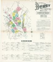
Abstract:
Sanborn fire insurance maps are a rich
Alternative Title:
Apr. 1912, Derby, Conn., Apr. 1912, Derby, Conn. Shelton., and Derby and Shelton, New Haven County, Connecticut.
Description:
"22 sheets. (4763)."
Subject (Geographic):
Derby (Conn.)--Maps
Subject (Name):
Library of Congress. Map Division Stamp
Subject (Topic):
--Derby--Maps
Found in:
Beinecke Rare Book and Manuscript Library > Insurance maps of Derby and Shelton, New Haven County, Connecticut.
Creator:
Published / Created:
c1903.
Call Number:
792 1903
Container / Volume:
BRBL_00519
Image Count:
2
Resource Type:
Maps , Atlases & Globes
Alternative Title:
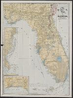
Hammonds 16 x 22 map of Florida
Description:
Index on verso. and Inset: [Steamship routes on U.S. Atlantic coast].
Publisher:
C.S. Hammond & Co.,
Subject (Geographic):
Florida--Maps
Subject (Name):
Clyde Steamship Company
Subject (Topic):
Railroads--Florida--Maps
Found in:
Beinecke Rare Book and Manuscript Library > The Clyde Steamship Co. map of Florida : showing routes and railroad connections.
Creator:
Published / Created:
ca. 1702?]
Call Number:
1973 Folio 18
Image Count:
1
Resource Type:
Maps , Atlases & Globes
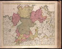
Description:
cm. No. 22 of 87 maps bound together.
Publisher:
Gerard Valck,
Subject (Geographic):
Germany, Northern--Maps --Early works to
Subject (Name):
Schenk, Peter, 1660-1718 or 1719. Atlantis sylloge compendiosa., Valck, G. (Gerard), 1651 or 1652-1726. Atlantis sylloge compendiosa., and Valck, Leonard, 1675-1746.
Found in:
Beinecke Rare Book and Manuscript Library > Circulus Saxoniae Inferioris, divisa in ducatus Brunsuici, Zellae, Holsatiae, Meklenburgi et Bremae, archiepiscopatum Magdeburgi, et episcopatus Hildesii et Halberstadii [cartographic material] / per Gerardi et Leonardi Valk, cum privilegio.
Published / Created:
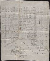
1847 February 22
Call Number:
WA MSS S-1882
Image Count:
1
Resource Type:
Maps , Atlases & Globes
Abstract:
Autograph manuscript map , drawn on
Description:
Map has been repaired with two pieces
Subject (Geographic):
San Francisco (Calif.) --Maps
Subject (Name):
Bartlett, Washington A
Found in:
Beinecke Rare Book and Manuscript Library > Map of San Francisco, Calif., 1847
Branch:v1.61.6 ,Deployed:2024-06-12T09:55:31-04:00