Search
You Searched For
Search Results
- Creator:
- United States. Office of Strategic Services. Research and Analysis Branch
- Published / Created:
- [1943]
- Call Number:
- 382 1943
- Container / Volume:
- BRBL_00175
- Image Count:
- 1
- Resource Type:
- Maps, Atlases & Globes
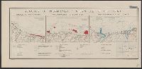
- Description:
- "22 November 1943."
- Subject (Geographic):
- Normandy (France)--Maps
- Subject (Topic):
- Beaches--France--Normandy--Maps
- Found in:
- Beinecke Rare Book and Manuscript Library > Beaches of Normandy - Vierville to Houlgate [cartographic material] / compiled and drawn in the Branch of Research and Analysis, OSS.
- Creator:
- From the Collection: Kissinger, Henry, 1923-2023
- Published / Created:
- 1970-1979, undated
- Call Number:
- MS 2004
- Container / Volume:
- Box 206, folder 2
- Image Count:
- 130
- Found in:
- Manuscripts and Archives > Henry A. Kissinger papers, part III (MS 2004) > Series V: Writing and Research Materials > Research files for books > White House Years > Maps and photographs for White House Years
- Creator:
- United States. Office of Strategic Services. Research and Analysis Branch
- Published / Created:
- 1944
- Call Number:
- 28 1944D
- Container / Volume:
- BRBL_00023E
- Image Count:
- 1
- Resource Type:
- Maps, Atlases & Globes
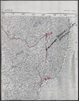
- Description:
- "No. 3417--R & A, OSS; 22 June 1944."
- Subject (Geographic):
- Visayan Islands (Philippines)--Maps
- Subject (Topic):
- --Maps
- Found in:
- Beinecke Rare Book and Manuscript Library > Philippine Islands, transportation facilities of the northern Visayan Islands.
- Creator:
- United States. Office of Strategic Services. Research and Analysis Branch
- Published / Created:
- 1944
- Call Number:
- 28 1944C
- Container / Volume:
- BRBL_00023E
- Image Count:
- 1
- Resource Type:
- Maps, Atlases & Globes
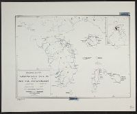
- Description:
- "No. 3764--R & A, OSS; 22 June 1944."
- Subject (Geographic):
- Visayan Islands (Philippines)--Maps
- Subject (Topic):
- --Maps
- Found in:
- Beinecke Rare Book and Manuscript Library > Philippine Islands, transportation facilities of the southern Visayan Islands.
- Published / Created:
- 1918
- Call Number:
- 11hc 1918-Z12
- Container / Volume:
- BRBL_00010G
- Image Count:
- 2
- Resource Type:
- Maps, Atlases & Globes
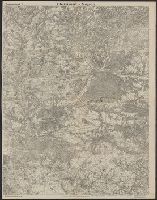
- Description:
- On verso: Map with "Bl.22.La Malmaison
- Subject (Geographic):
- France--Maps
- Found in:
- Beinecke Rare Book and Manuscript Library > Clermont-Noyon.
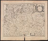
- Call Number:
- 402 M59 1630
- Container / Volume:
- BRBL_00233A
- Image Count:
- 2
- Resource Type:
- Maps, Atlases & Globes
- Description:
- Signature R, page number 22 on verso.
- Subject (Geographic):
- Milan (Italy : Province)--Maps--Early
- Found in:
- Beinecke Rare Book and Manuscript Library > Stato di Milano.
- Published / Created:
- 1965-1966
- Call Number:
- GEN MSS 1319
- Container / Volume:
- Box 4
- Image Count:
- 1640
- Found in:
- Beinecke Rare Book and Manuscript Library > The Vinland Map and the Tartar Relation: proofs and subject files (GEN MSS 1319) > Series II: Subject files > Newspaper and magazine clippings
- Creator:
- From the Collection: Kissinger, Henry, 1923-2023
- Published / Created:
- 2004
- Call Number:
- MS 1981
- Container / Volume:
- Box 745, folder 9
- Image Count:
- 176
- Found in:
- Manuscripts and Archives > Henry A. Kissinger papers, part II (MS 1981) > Series III: Post-Government Career > Speeches and writings > General > Testimony before Senate Foreign Relations Committee on "Middle East: Re-thinking the Road Map," Feb 24, 2004 [2 of 2]
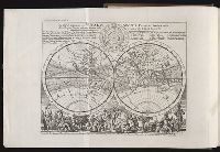
- Creator:
- Moll, Herman, d. 1732
Salmon, Thomas, 1679-1767
- Published / Created:
- 1739
- Call Number:
- 1996 +91
- Image Count:
- 3
- Resource Type:
- Books, Journals & Pamphlets
- Description:
- Frontispiece map, 25 x 41 cm.
- Subject (Geographic):
- Madras (India)--Maps--Early works to
- Found in:
- Beinecke Rare Book and Manuscript Library > Modern history: or, The present state of all nations. Describing their respective situations, persons, habits, ... animals and minerals. ... By Mr. Salmon. Illustrated with cuts and maps ... by Herman Moll ...
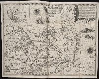
- Creator:
- Langren, Arnold Florent van, 1580-1644
- Published / Created:
- 1595
- Call Number:
- Pequot +L65
- Collection Title:
- Nauigatio ac itinerarium Iohannis Hugonis Linscotani in Orientalem siue Lusitanorum Indiam
- Image Count:
- 1
- Description:
- Bound in following page 22.
- Subject (Geographic):
- Borneo --Maps
- Found in:
- Beinecke Rare Book and Manuscript Library > Exacta & accurata delineatio cum orarum maritimarum tum etiam locorum terrestrium quae in regionibus China, Cauchinchina, Camboia sive Champa, Syao, Malacca, Arracamn & Pegu ...