Search
You Searched For
Search Results
- Published / Created:
- 1883
- Call Number:
- 764cea V75 1883
- Container / Volume:
- BRBL_00461
- Image Count:
- 1
- Resource Type:
- Maps, Atlases & Globes
- Found in:
- Beinecke Rare Book and Manuscript Library > Vineyard Sound [Massachusetts] : from Woods Hole to Cuttyhunk / United States Coast Survey.
- Creator:
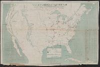
- United States. Army. Signal Corps
- Published / Created:
- 1872
- Call Number:
- 75CF 1872
- Container / Volume:
- BRBL_00409
- Image Count:
- 1
- Resource Type:
- Maps, Atlases & Globes
- Found in:
- Beinecke Rare Book and Manuscript Library > War Department weather map / published by authority of the Secretary of War.
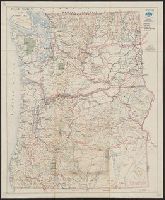
- Creator:
- Westgard, A. L. (Anthon L.), b. 1865
- Published / Created:
- c1920.
- Call Number:
- 847gmb 1920A
- Container / Volume:
- BRBL_00629
- Image Count:
- 2
- Resource Type:
- Maps, Atlases & Globes
- Found in:
- Beinecke Rare Book and Manuscript Library > Washington and Oregon / prepared and issued by Touring Information Board, American Automobile Association ; prepared by A.L. Westgard, field representative, American Automobile Association ; F.S.R. jr.
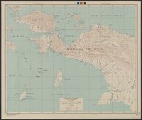
- Creator:
- United States. Army Map Service
- Published / Created:
- [19]44.
- Call Number:
- 269gmb 1945B
- Container / Volume:
- BRBL_00023A
- Image Count:
- 1
- Resource Type:
- Maps, Atlases & Globes
- Found in:
- Beinecke Rare Book and Manuscript Library > Western New Guinea : special strategic map / compiled by the Army Map Service.
- Creator:
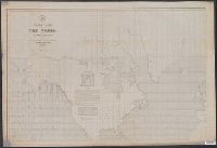
- Maury, Matthew Fontaine, 1806-1873
- Published / Created:
- 1851
- Call Number:
- 11DB 1851A-1
- Container / Volume:
- BRBL_00774
- Image Count:
- 1
- Resource Type:
- Maps, Atlases & Globes
- Found in:
- Beinecke Rare Book and Manuscript Library > Whale chart [cartographic material] : preliminary sketch / by M.F. Maury, A.M. Lieut., U.S. Navy ; constructed by Lts. Leigh. Herndon & Fleming & Pd. Midn. Jackson.
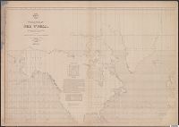
- Creator:
- Maury, Matthew Fontaine, 1806-1873
- Published / Created:
- 1852
- Call Number:
- 11cfk 1850F
- Container / Volume:
- BRBL_00774
- Image Count:
- 4
- Resource Type:
- Maps, Atlases & Globes
- Found in:
- Beinecke Rare Book and Manuscript Library > Whale chart of the world [cartographic material] / by M.F. Maury, L.L.D. Lieut. U.S. Navy, superin'dt. of U.S.N. Observatory ; compiled from materials in the Bureau of Ordnance and Hydrography by P.M. A.C. Jackson.
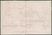
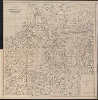
- Published / Created:
- 1917
- Call Number:
- 762gcr W588 1917
- Container / Volume:
- BRBL_00451
- Image Count:
- 2
- Resource Type:
- Maps, Atlases & Globes
- Found in:
- Beinecke Rare Book and Manuscript Library > White Mountain National Forest, New Hampshire and Maine / U.S. Department of Agriculture, Forest Service, Henry S. Graves, Forester.
- Creator:
- Maury, Matthew Fontaine, 1806-1873
- Published / Created:
- 1850
- Call Number:
- 11cfk 1850D-1
- Container / Volume:
- BRBL_00773
- Image Count:
- 4
- Resource Type:
- Maps, Atlases & Globes
- Found in:
- Beinecke Rare Book and Manuscript Library > Wind and current chart of the North Atlantic [cartographic material] : thermal sheet / by M.F. Maury, A.M. Lieut. U.S. Navy, Superint'dt. of U.S.N. Observatory ; compiled from materials in the Bureau of Ordnance and Hydrography, Commodore Lewis Warrington, Chief of Bureau ; drawn by Lt. Benjn. S. Gantt, U.S.N.
- Creator:
- Maury, Matthew Fontaine, 1806-1873
- Published / Created:
- 1850
- Call Number:
- 11cfk 1850D-1
- Container / Volume:
- BRBL_00773
- Image Count:
- 8
- Resource Type:
- Maps, Atlases & Globes
- Found in:
- Beinecke Rare Book and Manuscript Library > Wind and current chart of the North Atlantic [cartographic material] : thermal sheet / by M.F. Maury, A.M. Lieut. U.S. Navy, Superint'dt. of U.S.N. Observatory ; compiled from materials in the Bureau of Ordnance and Hydrography, Commodore Lewis Warrington, Chief of Bureau ; drawn by Lt. Benjn. S. Gantt, U.S.N.