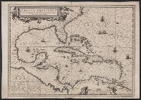
Insulae Americanae in Oceano Septentrionali cum terris adjacentibus and Insvlae Americanae in Oceano Septentrionali cum terris adiacentibus
Description:
Includes embellished title cartouche, dedication with coats-of-arms, scale and ill. of ships at sea., No text on verso., Sheet measures 40.1 x 56.8 cm. Ms. notes on verso. Stamp on verso: T.W. Streeter., and Shows southeast coast of North America from Virginia to north coast of South America to east of Trinidad, west coast of Central America, West Indies.
Publisher:
Apud Ioannem Ianssonium,
Subject (Geographic):
Caribbean Area--Maps--Early works to 1800, Mexico, Gulf of--Maps--Early works to 1800, and West Indies--Maps--Early works to 1800
Subject (Name):
Streeter, Thomas W.--(Thomas Winthrop),--1883-1965--Stamp
Subject (Topic):
Coasts--North America--Maps--Early works to 1800 and Coasts--South America--Maps--Early works to 1800
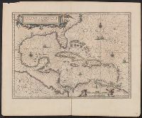
Insulae Americanae in Oceano Septentrionali cum terris adjacentibus and Insvlae Americanae in Oceano Septentrionali cum terris adiacentibus
Description:
Appears in various Dutch eds. of Jansson's Nieuwen atlas., Includes scales in milliaria germanica and mill, and Shows southeast coast of North America from Virginia to north coast of South America to east of Trinidad, west coast of Central America, West Indies.
Publisher:
Apud Ioannem Ianssonium,
Subject (Geographic):
Caribbean Area--Maps--Early works to 1800, Mexico, Gulf of--Maps--Early works to 1800, and West Indies--Maps--Early works to 1800
Subject (Name):
Jansson, Jan, 1588-1664. Atlas novus. Dutch
Subject (Topic):
Coasts--North America--Maps--Early works to 1800 and Coasts--South America--Maps--Early works to 1800
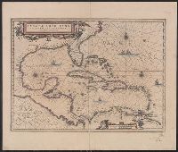
Insulae Americanae in Oceano Septentrionali cum terris adjacentibus and Insvlae Americanae in Oceano Septentrionali cum terris adiacentibus
Description:
Appears in various French eds. of Jansson's Nouvel atlas., Includes embellished title cartouche, dedication with coat, Includes scales in milliaria germanica and milliaria hispanica., and Mounted on linen. Sheet measures 49.8 x 58.6 cm. Cross Collection no. 233.
Publisher:
Apud Ioannem Ianssonium,
Subject (Geographic):
Caribbean Area--Maps--Early works to 1800, Mexico, Gulf of--Maps--Early works to 1800, and West Indies--Maps--Early works to 1800
Subject (Name):
Jansson, Jan, 1588-1664. Atlas novus. French
Subject (Topic):
Coasts--North America--Maps--Early works to 1800 and Coasts--South America--Maps--Early works to 1800
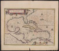
Insulae Americanae in Oceano Septentrionali cum terris adjacentibus and Insvlae Americanae in Oceano Septentrionali cum terris adiacentibus
Description:
From Jansonius's and Hondius's Atlas novus ... Amstelodami : Apud Ionnem Ianssonium & Henricum Hondium, 1638., Includes scales in milliaria germanica and leucae hispanicae., and Show southeast coast of North America from Virginia to north coast of South America to east of Trinidad, west coast of Central America, West Indies.
Publisher:
Apud Ioannem Ianssonium,
Subject (Geographic):
Caribbean Area--Maps--Early works to 1800, Mexico, Gulf of--Maps--Early works to 1800, and West Indies--Maps--Early works to 1800
Subject (Name):
Hondius, Hendrik, 1597-1651. Atlas novus and Jansson, Jan, 1588-1664. Atlas novus
Subject (Topic):
Coasts--North America--Maps--Early works to 1800 and Coasts--South America--Maps--Early works to 1800
Insulae Americanae in Oceano Septentrionali cum terris adjacentibus and Insvlae Americanae in Oceano Septentrionali cum terris adiacentibus
Description:
From Jansonius's and Hondius's Atlas novus ... Amstelodami : Apud Ionnem Ianssonium & Henricum Hondium, 1638., Includes embellished title cartouche, scale and ill. of ships at sea., Sheet measures 49 x 57.8 cm. Cross Collection no. 234., and Text in Latin on verso with running title "Hispaniola & Cuba, caption title "Insulae Americae praecipuae sunt Hispaniola et Cuba," and signature 4U.
Publisher:
Apud Ioannem Ianssonium,
Subject (Geographic):
Caribbean Area--Maps--Early works to 1800, Mexico, Gulf of--Maps--Early works to 1800, and West Indies--Maps--Early works to 1800
Subject (Name):
Hondius, Hendrik, 1597-1651. Atlas novus and Jansson, Jan, 1588-1664. Atlas novus
Subject (Topic):
Coasts--North America--Maps--Early works to 1800 and Coasts--South America--Maps--Early works to 1800
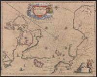
Nova et accvrata Poli Arctici et terrarum circum Iacentium descriptio
Description:
Cross collection no. 51., From: Nouvel atlas, ou, Theatre du Monde ... Amstelodami : Apud Ioannem Ianssonium, 1649., In Latin, with French text on verso; running title "Description"; caption title "Le pole Arctique avec les regions situees dessous"; sig. P., and Includes ill. and decorative cartouche.
Publisher:
Apud Ioannem Ianssonium,
Subject (Geographic):
Arctic Regions--Maps--Early works to 1800
Subject (Name):
Jansson, Jan, 1588-1664. Nouvel atlas, ou, theatre du monde
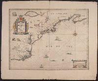
Appears in French editions of Jansson's and Hondius's Atlas n, French text on verso, with signature 5d., Hand col. Sheet measures 47.5 x 57 cm., Relief shown pictorially., and Stamp on verso: Yale University Library Karpinski-von Wieser Map Collection.
Publisher:
Johannes Janssonius excudit,
Subject (Geographic):
Atlantic States--Maps--Early works to 1800 and Maritime Provinces--Maps--Early works to 1800
Subject (Name):
Hondius, Hendrik, 1597-1651. Atlas novus. French and Jansson, Jan, 1588-1664. Atlas novus. French
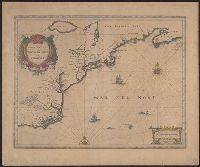
From Jansson's Atlas major ... Amstelodami : Apud Johannis Janssonij Haeredes, [1675]., Hand col. Sheet measures 50.8 x 60 cm. Initial on verso hand-colored. Cross Collection no. 180., Ill. of animals and Indian village., Latin text on verso, with no signature., and Relief shown pictorially.
Publisher:
Johannes Janssonius excudit,
Subject (Geographic):
Atlantic States--Maps--Early works to 1800 and Maritime Provinces--Maps--Early works to 1800
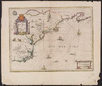
Appears in Dutch editions of Jansson's Atlas novus., Dutch text on verso, with catchword "West-Indien" and signature 2C., Hand col. Sheet measures 50 x 60.5 cm., Ill. of animals and Indian village., and Relief shown pictorially.
Publisher:
Johannes Janssonius excudit,
Subject (Geographic):
Atlantic States--Maps--Early works to 1800 and Maritime Provinces--Maps--Early works to 1800