Album containing 122 engravings by Stukeley, many in proof, assembled by the artist himself. Contents include 85 engravings from Itinerarium Curiosum and 23 from Stonehenge, a Temple Restor’d to the British Druids.
Description:
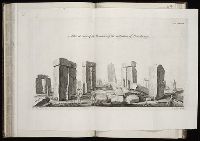
Folio plate, tab bound. and Plate numbered 113.
Subject (Geographic):
Great Britain --Antiquities --Early works to 1800 and Wiltshire (England) --Antiquities
Subject (Topic):
Megalithic monuments --England --Wiltshire and Stonehenge (England)--Early works to 1800
Atlas minor: or a set of sixty-two new and correct maps, of all parts of the world. All composed
Image Count:
1
Resource Type:
Maps, Atlases & Globes
Description:
Autograph of Gravely. Autograph of Baldock. Autograph of Aston. Autograph of W. Alington. and Teaching resource: Professor John Mack Faragher, History 141: The American West.
Subject (Geographic):
America--Maps, Europe, Northern--Maps--Early works to 1800, Great Britain--Maps--Early works to 1800, and Ireland--Maps--Early works to 1800
Geographical, historical, political, philosophical and mechanical essays : the first, containing an
Image Count:
1
Resource Type:
Maps, Atlases & Globes
Description:
This second issue of the second edition includes the original map with title: A general map of the middle British colonies in America; viz. Virginia, Ma`riland, De`laware, Pensilvania, New-Jersey, New-York, Connecticut, and Rhode Island: of Aquanishuonigy
Subject (Geographic):
Erie, Lake., Middle Atlantic States--Maps., Ohio River Valley--Maps., and Ontario, Lake (N.Y. and Ont.)
Collection Created:
Philadelphia: Printed by B. Franklin, and D. Hall., MDCCLV [1755]
Subject: Map of the central part of the United States showing the middle Atlantic states, and the Ohio River Valley region. Includes anecdotes on the different Indian nations and the lands. Shows dates of settlements and agreements, locations of quarries,
Alternative Title:
Middle British colonies.
Description:
Differs from other copies in extension of the Connecticut River north beyond "Great Falls." Differs also in coloration of boundaries: Ohio River is colored as a boundary: Pennsylvania is shown as extending north to Lake Ontario, etc. and Shows "West longitude
Publisher:
Printed for Carington Bowles,
Subject (Geographic):
Canada--Maps--Early works to 1800, Middle Atlantic States--Maps--Early works to 1800, Northeastern States--Maps--Early works to 1800, and Ohio River Valley--Maps--Early works to 1800
Subject (Name):
Bowles, Carington, 1724-1793, publisher
Subject (Topic):
British--America--Maps--Early works to 1800 and Chron.--1771