Skip to search
Skip to main content
Skip to first result
Search
You Searched For
Genre
Maps
New Search
Search Results
Published / Created:
1900?]
Call Number:
475CBD 1900
Container / Volume:
BRBL_00262
Image Count:
1
Resource Type:
Maps, Atlases & Globes
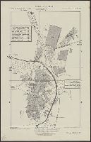
Description:
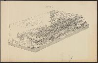
Bird's-eye view of Albania, showing topography and some towns. and Inset map of Italy, Central Europe, and the Balkan Peninsula.
Publisher:
s.n.,
Subject (Geographic):
Albania--Maps
Found in:
Beinecke Rare Book and Manuscript Library > Albania.
Creator:
Published / Created:
1906
Call Number:
771cbf Al13 1906
Image Count:
1
Resource Type:
Maps, Atlases & Globes
Description:
"Henry Gannet, Chief Geographer, H.M. Wilson, Geographer in charge; Topography by Frank Sutton and J.H. Jennings; surveyed in 1891-1892.", "Reprinted Nov. 1906.", "Surveyed in cooperation with the State of New York.", Contour interval 20 feet., and Relief shown by contours.
Publisher:
U.S. Geological Survey,
Subject (Geographic):
Albany Region (N.Y.)--Maps
Subject (Name):
Gannett, Henry, 1846-1914
Found in:
Beinecke Rare Book and Manuscript Library > Albany and vicinity, New York.
Creator:
Published / Created:
1945?]
Call Number:
281 C281 1945A
Container / Volume:
BRBL_00025
Image Count:
1
Resource Type:
Maps, Atlases & Globes
Alternative Title:
R & A, OSS ; no. A-3462
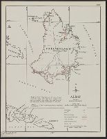
Subject (Geographic):
Albay (Philippines)--Maps
Found in:
Beinecke Rare Book and Manuscript Library > Albay [cartographic material].
Creator:
Published / Created:
1903
Call Number:
737 1903
Container / Volume:
BRBL_00384
Image Count:
1
Resource Type:
Maps, Atlases & Globes
Description:
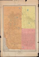
Relief shown by hachures and spot heights.
Publisher:
Dept. of the Interior,
Subject (Geographic):
Alberta--Maps and Saskatchewan--Maps
Subject (Name):
White, James, 1863-1928
Subject (Topic):
Public lands--Alberta--Maps and Public lands--Saskatchewan--Maps
Found in:
Beinecke Rare Book and Manuscript Library > Alberta and western portions of Saskatchewan and Assiniboia / James White, Geographer.
Creator:
Published / Created:
c1891.
Call Number:
814 D889 1891
Container / Volume:
BRBL_00558
Image Count:
2
Resource Type:
Maps, Atlases & Globes
Abstract:
Also shows part of Superior, Wis.
Alternative Title:
Map of the city of Duluth, St. Louis County, Minn., and vicinity
Description:
Includes advertisement., Library's copy missing upper left corner and separated in two sheets at center fold., Oriented with north to upper right., and Soundings in feet.
Publisher:
Albertson & Chamberlain,
Subject (Geographic):
Duluth Metropolitan Area (Minn.)--Maps and Superior (Wis.)--Maps
Subject (Name):
Albertson & Chamberlain
Found in:
Beinecke Rare Book and Manuscript Library > Albertson's map of the city of Duluth, St. Louis County, Minn., and vicinity / drawn and engraved by Frederick B. Roe, civil engineer and map publisher.
Published / Created:
[1640?]
Call Number:
3618 1640
Image Count:
1
Resource Type:
Maps, Atlases & Globes
Description:
Elbe River from source to sea.
Publisher:
Clemendt de Jonghe,
Subject (Geographic):
Elbe River (Czech Republic and Germany)--Maps--Early works to 1800
Found in:
Beinecke Rare Book and Manuscript Library > Albis Fluvius Germaniae Celebris A Fontibus ad Ostie ...
Creator:
Published / Created:
c1991.
Call Number:
844 Al16 1971
Container / Volume:
BRBL_00604
Image Count:
2
Resource Type:
Maps, Atlases & Globes
Alternative Title:
Official map and guide to Alcatraz
Description:
Includes text, ill. and cellhouse plan., Relief shown pictorially., and Text, ill. and timeline on verso.
Publisher:
Rufus Graphics,
Subject (Geographic):
Alcatraz Island (Calif.)--Maps and Alcatraz Island (Calif.)--Maps, Tourist
Subject (Name):
Reineck & Reineck and Rufus Graphics
Found in:
Beinecke Rare Book and Manuscript Library > Alcatraz / published in cooperation with Golden Gate National Park Association ; design, Reineck & Reineck.
Creator:
Published / Created:
1943
Call Number:
675 Al16 1943
Container / Volume:
BRBL_00349
Image Count:
1
Resource Type:
Maps, Atlases & Globes
Alternative Title:
GSGS (Series) ; 4241., Provisional G. S. G. S. no. 4241, and Spanish Morocco 5 000.
Description:
In upper margin: Spanish Morocco 1:5,000 ... and Includes index to points of interest and principal streets.
Publisher:
Army Map Service, U. S. Army,
Subject (Geographic):
Qaṣr al-Kabīr (Larache, Morocco)--Maps
Found in:
Beinecke Rare Book and Manuscript Library > Alcazarquivir ; city plan. Prepared under the direction of the chief of engineers, U. S. Army.
Published / Created:
1888
Call Number:
32 Ox1 1888
Container / Volume:
BRBL_00053
Image Count:
1
Resource Type:
Maps, Atlases & Globes
Publisher:
Alden & Co.,
Subject (Geographic):
Oxford (England)--Maps
Found in:
Beinecke Rare Book and Manuscript Library > Alden's new plan of the city & University of Oxford/ Lithographed by W. & A.K. Johnston.
Call Number:
1977 +392
Collection Title:
A survey of the cities of London and Westminster : containing the original, antiquity, increase
Image Count:
1
Description:
Plate between p. 94-95.
Subject (Geographic):
London
Collection Created:
London : Printed for A. Churchill, J. Knapton, R. Knaplock, J. Walthoe [and 6 others],
Found in:
Beinecke Rare Book and Manuscript Library > Alders Gate Ward and St. Martins le grand liberty taken from the last survey with corrections
Branch:v1.61.6 ,Deployed:2024-06-12T09:55:19-04:00