Skip to search
Skip to main content
Skip to first result
Search
You Searched For
Resource Type
Maps, Atlases & Globes
New Search
Search Results
Published / Created:
1864
Call Number:
793hc M71 1864B
Container / Volume:
BRBL_00520
Image Count:
1
Resource Type:
Maps, Atlases & Globes
Description:
Compass arrow., Explanation of diagram from the five stand points of the Mobile fight / D.G. Farragut., Hand col., and Inset map: Points of collision of the different boats upon the Ram.
Publisher:
s.n.] ,
Subject (Geographic):
United States--History--Civil War, 1861-1865--Naval operations
Subject (Topic):
Mobile Bay, Battle of, Ala., 1864
Found in:
Beinecke Rare Book and Manuscript Library > Entrance of Rear Admiral Farragut into Mobile Bay, August 5th 1864.
Creator:
Published / Created:
1883
Call Number:
7645cea 1883
Container / Volume:
BRBL_00463
Image Count:
1
Resource Type:
Maps, Atlases & Globes
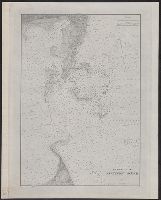
Description:
"Plate no. 1442.", Depths shown by isolines and soundings., Includes bouys and soundings, and Includes tidal information.
Publisher:
United States Coast Survey]
Subject (Geographic):
Nantucket Sound (Mass.)--Maps
Subject (Topic):
Nautical charts--Massachusetts--Nantucket Sound
Found in:
Beinecke Rare Book and Manuscript Library > Entrance to Nantucket Sound / United States Coast Survey.
Creator:
Published / Created:
1861
Call Number:
63 1861
Container / Volume:
BRBL_00334
Image Count:
1
Resource Type:
Maps, Atlases & Globes
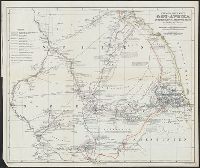
Alternative Title:
Ost-Afrika zwischen Chartúm & dem Rothen Meere
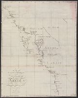
Description:
Includes text., Prime meridians: Paris and Greenwich., and Relief shown by hachures.
Publisher:
Justus Perthes,
Subject (Geographic):
Eritrea--Discovery and exploration--Maps, Ethiopia--Discovery and exploration--Maps, and Sudan--Discovery and exploration--Maps
Subject (Name):
Heuglin, Theodor von,--1824-1876 and Justus Perthes (Firm : Gotha, Germany)
Found in:
Beinecke Rare Book and Manuscript Library > Entwurf einer Karte von Ost-Afrika zwischen Chartúm & dem Rothen Meere, bis Sauakin und Massaua : nach allen vorhandenen Quellen entworfen von A. Petermann, zum Gebrauch der v. Heuglin'schen Expedition ausgeführt durch Justus Perthes' Geographisches Ans
Creator:
Published / Created:
1918
Call Number:
11hc 1918B
Container / Volume:
BRBL_00010E
Image Count:
1
Resource Type:
Maps, Atlases & Globes
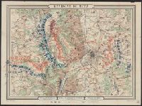
Description:
Bottom Margin: Bataille de Rezonville (16 Août 8h. du soir) -- Bataille de Gravelotte + St. Privat. (18 Août 7h du soir) -- Bataille de Borny (14 Août 8h du soir)., Coordinates not present on map and are approximated., Relief shown by hachures., and Troop locati
Publisher:
Hédin,
Subject (Geographic):
Moselle (France : 1790-1871)--Maps.
Subject (Topic):
Franco-Prussian War, 1870-1871--Campaigns--France, Eastern--Maps.
Found in:
Beinecke Rare Book and Manuscript Library > Environs de Metz / dessiné par Hédin géographe.
Branch:v1.61.8 ,Deployed:2024-06-20T11:14:46-04:00