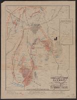
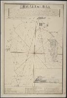
Inset map: "Site of Gen. Gregg's Cavalry Operations. Three Miles east of Gettysburg." "Scale : 1 Inch = 1 Mile.", Legend on map., and Map "Compliments of Zeigler & Holtzworth Livery."
Publisher:
Gettysburg Memorial Battlefield Association,
Subject (Geographic):
United States--History--Civil War, 1861-1865--Campaigns--Maps
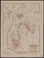
"Cette carte représent la Terre, telle que les premiers Grecs se la figuroient. Toutes les bases de cette mappemonde systématique sont prises dans le texte des Poëtes les plus anciens.", Has watermarks., Includes text., and Relief shown pictorially.
Publisher:
s.n.,
Subject (Geographic):
Mediterranean Region--History--Maps
Subject (Topic):
Argonauts (Greek mythology)--Travel--Maps, Classical geography in literature--Maps, Geographical myths--Maps, and Odysseus (Greek mythology)--Travel--Maps
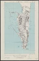
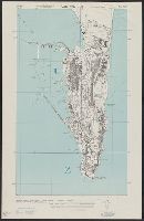
"Copied from British Admiralty chart no. 144, corrected to 1942. Revised in part from R. A. F. aerial photographs.", In upper margin: Spain ... City plan., Military grid., Relief shown by hachures., and Some buildings and other features are named.
"Copied from British Admiralty chart no. 144, corrected to 1942. Revised in part from R. A. F. aerial photographs.", In upper margin: Spain ... City plan., Military grid., Relief shown by hachures., and Some buildings and other features are named.