Skip to search
Skip to main content
Skip to first result
Search
You Searched For
Access
Public
Genre
Maps
New Search
Search Results
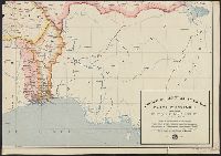
Published / Created:
1922
Call Number:
654 1922
Container / Volume:
BRBL_00344
Image Count:
2
Resource Type:
Maps, Atlases & Globes
Description:
2 sheets only. Western sheets wanting.
Publisher:
Service Géographique de l'Afrique Occidentale française,
Subject (Geographic):
Africa, East--Administrative and political divisions--Maps and Africa, East--Maps
Subject (Topic):
French--Africa, East--Maps
Found in:
Beinecke Rare Book and Manuscript Library > Afrique Occidentale française, carte d'ensemble semi-murale. Politique et administrative / dressée e publiée par le Service Géographique de l'Afrique Occidle. françse. à Dakar sous la direction du Commandant Ed. de Martonne.
Creator:
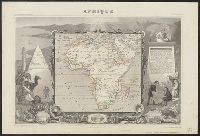
Published / Created:
[184-],
Call Number:
60 184X
Container / Volume:
BRBL_00326
Image Count:
1
Resource Type:
Maps, Atlases & Globes
Description:
Hand col. Sheet measures 35 x 52 cm., In upper margins: Atlas universel illustré ... Ancien continent., Includes engraved illustrations in borders, statistics, descripti, Inset views: [1.] Alexandrie -- [2.] Le Caire -- [3.] Alger., and Relief shown by hachures.
Publisher:
Chez A. Combette, editeur, rue de la Parcheminerie 15,
Subject (Geographic):
Africa--Maps
Subject (Name):
Bonheur, Raimond, Combette, A, Lemercier, Alfred, printer, and Levasseur, V
Found in:
Beinecke Rare Book and Manuscript Library > Afrique [cartographic material] / gravé par Laguillermie ; illustré par Raimond Bonheur, peintre ; géographie et statistique de V. Levasseur, ingenieur geographe.
Creator:
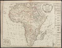
Published / Created:
l'an IIIe. de la République Franc? [1794 or 1795]
Call Number:
60 1794A
Container / Volume:
BRBL_00324
Image Count:
1
Resource Type:
Maps, Atlases & Globes
Description:
Includes chart showing political divisions., Prime meridian: Ferro., Relief shown pictorially., and Watermarks include Maltese cross within rosary.
Publisher:
chez le Cit. Lamarche géog? rue du Foin Saint Jacques au collége de Mtre. Gervais,
Subject (Geographic):
Africa--Maps--Early works to 1800
Subject (Name):
Arrivet, J and Delamarche, Charles François, 1740-1817
Found in:
Beinecke Rare Book and Manuscript Library > Afrique divisée en ses principaux empires et royaumes / par Robert de Vaugondy, géographe ; corrigée par Lamarche, son successeur et successeur de Fortin mécanicien pour les globes et sphéres ; Arrivet inv. & sculp.
Creator:
Published / Created:
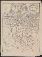
1929
Call Number:
653 1929
Container / Volume:
BRBL_00343
Image Count:
1
Resource Type:
Maps, Atlases & Globes
Alternative Title:
Afrique equatorle. Françse
Subject (Geographic):
Africa, French-speaking Equatorial--Maps
Subject (Name):
Belgium. Ministère des colonies
Subject (Topic):
French--Africa--Maps
Found in:
Beinecke Rare Book and Manuscript Library > Afrique equator[ia]le Franç[ai]se [cartographic material] / dressée par A. Meunier.
Creator:
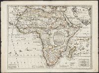
Published / Created:
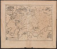
1689
Call Number:
60 1689
Container / Volume:
BRBL_00322
Image Count:
1
Resource Type:
Maps, Atlases & Globes
Description:
"Avec privilege du Roy.", dgvmp2008., Hand col. Sheet measures 51 x 70 cm. Ms. no. on verso: 49., Has watermarks., Includes text, ill., and Relief shown pictorially.
Publisher:
Chez I.B. Nolin, sur le Quay de l'Horloge du Palais ...,
Subject (Geographic):
Africa--Maps--Early works to 1800
Subject (Name):
Loon, H. V. (Herman van) and Nolin, Jean Baptiste, 1648-1708
Found in:
Beinecke Rare Book and Manuscript Library > Afrique selon les relations les plus nouvelles / dressée et dediée par le P. Coronelli, cosmographe de la serenissime republique de Venise, a Monseigneur le duc de Brissac, pair de France ; H. Van Loon, sculp.
Call Number:
Ck3 35p
Collection Title:
Missive van William Penn ... : Geschreven aan de commissarissen van de Vrye Societeyt der
Image Count:
1
Description:
Facing p. 22.
Subject (Geographic):
Pennsylvania --Description and travel and Philadelphia (Pa.) --Description and travel
Subject (Name):
Holme, Thomas, d. 1695 and Paschall, Thomas, 1634-1718. Abstract of a letter. Dutch
Subject (Topic):
Indians --Pennsylvania
Collection Created:
Amsterdam : J. Claus, 1684
Found in:
Beinecke Rare Book and Manuscript Library > Afteykeninge van de Stadt Philadelphia in de Provinstie van Penn-sylvania in Americae na de Copie tot London. en intneder duyts laeten Snyden door Jacob Claus
Creator:
Published / Created:
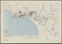
1942
Call Number:
67 Ag13 1942
Container / Volume:
BRBL_00348
Image Count:
1
Resource Type:
Maps, Atlases & Globes
Alternative Title:
Morocco 10 000.
Description:
"Prepared under the direction of the chief of engineers, U. S. Army ... Compiled from base map of Ville d'Agadir, 1:10,000, Office of the military attache, Tangier, Morocco. Revised from U. S. H. O. chart no. 2239, R. A. F. aerial photos ... and Morocco,
Publisher:
Army Map Service, U. S. Army,
Subject (Geographic):
Agadir (Morocco)--Maps
Found in:
Beinecke Rare Book and Manuscript Library > Agadir; city plan.
Call Number:
402 M59 300
Container / Volume:
BRBL_00233A
Image Count:
1
Resource Type:
Maps, Atlases & Globes
Description:
Relief shown by hachures.
Subject (Geographic):
Milan (Italy : Province)--History--476-1492--Maps and Milan (Italy : Province)--Maps
Found in:
Beinecke Rare Book and Manuscript Library > Ager Mediolanensis medii aevi / Demczynski inc.
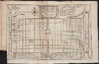
Published / Created:
[1635?]
Call Number:
3827 1635
Container / Volume:
BRBL_00176
Image Count:
2
Resource Type:
Maps, Atlases & Globes
Publisher:
G. Blaeu,
Subject (Geographic):
Mauritius--Maps--Early works to 1800
Found in:
Beinecke Rare Book and Manuscript Library > Ager Parisiensis Vulgo L'Isle de France ...
Published / Created:
[1635?]
Call Number:
3331 B47 1635
Container / Volume:
BRBL_00082
Image Count:
2
Resource Type:
Maps, Atlases & Globes
Description:
Preliminary record.
Subject (Geographic):
Beemster (Netherlands)--Maps--Early works to 1800 and North Holland (Netherlands)--Maps--Early works to 1800
Found in:
Beinecke Rare Book and Manuscript Library > Agri Biemstrani descriptio a L.I.S.
Branch:v1.61.6 ,Deployed:2024-06-12T09:55:33-04:00