The discoveries of John Lederer : in three several marches from Virginia, to the west of Carolina
Image Count:
1
Description:
Engraved by Cross. and Preceding title page.
Subject (Geographic):
North Carolina --Description and travel, North Carolina --Maps --Early works to 1800, Virginia --Description and travel, and Virginia --Maps --Early works to 1800
Subject (Name):
Talbot, William
Subject (Topic):
Indians of North America --North Carolina and Indians of North America --Virginia
The American military pocket atlas : being an approved collection of correct maps, both general and
Image Count:
1
Description:
Augst. 5th. 1776., Inset: A particular plan of Lake George. surveyed in 1756. By Capt. Jackson., and Teaching resource: Professor John Mack Faragher, History 141: The American West.
Publisher:
Printed for Robt. Sayer & Jno. Bennett, Map & Sea Chartsellers No. 53 Fleet Street, as the Act directs
Subject (Geographic):
North America --Maps --Early works to 1800 and United States --History --Revolution, 1775-1783 --Maps
Collection Created:
London : Printed for R. Sayer and J. Bennet, [1776]
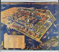
San Francisco Bay Exposition Company White, Ruth Taylor
Published / Created:
c1939
Call Number:
BrSides Zc72 939wh
Image Count:
1
Abstract:
An aerial panorama of the exposition grounds, with a portion of San Francisco in the foreground and whimsical sea monsters, whales, and boats in the water around the island.
Alternative Title:
Golden Gate International Exposition
Publisher:
San Francisco Bay Exposition
Subject (Geographic):
Oakland (Calif.), San Francisco (Calif.), and San Francisco-Oakland Bay Bridge (Oakland and San Francisco, Calif.)
Subject (Name):
Golden Gate International Exposition (1939-1940 : San Francisco, Calif.)
The generall historie of Virginia, New-England, and the Summer Isles : with the names of the
Image Count:
1
Abstract:
With inset map of "Ould Virginia" [with linen backing].
Description:
Engraved by Robert Vaughan, Ink washes on various vignettes., and Tipped-in facing title page.
Publisher:
Printed by I.D. and I.H. for Michael Sparkes
Subject (Name):
Smith, John, 1580-1631
Subject (Topic):
Indians of North America--Virginia., New England --History --Colonial period, ca. 1600-1775., Virginia --History --Colonial period, ca. 1600-1775, and Voyages and travels.
Collection Created:
London : Printed by I.[ohn] D.[awson] and I.[ohn] H.[aviland] for Michael Sparkes, 1624
The generall historie of Virginia, New-England, and the Summer Iles ...
Image Count:
1
Abstract:
Inset map of Virginia
Description:
Engraved by Robert Vaughan, Facing p. 41, and Printed by James Reeve
Publisher:
Printed by I.D. and I.H. for Michael Sparkes
Subject (Name):
Smith, John, 1580-1631
Subject (Topic):
Indians of North America--Virginia., New England --History --Colonial period, ca. 1600-1775., Virginia --History --Colonial period, ca. 1600-1775, and Voyages and travels.
Collection Created:
London : Printed by I.D. and I.H. for Michael Sparkes, 1624
Atlas minor: or a set of sixty-two new and correct maps, of all parts of the world. All composed
Image Count:
1
Description:
Autograph of Gravely. Autograph of Baldock. Autograph of Aston. Autograph of W. Alington. and Teaching resource: Professor John Mack Faragher, History 141: The American West.
Subject (Geographic):
America--Maps--Early works to 1800 and Fundy, Bay of--Maps
Atlas minor: or a set of sixty-two new and correct maps, of all parts of the world. All composed
Image Count:
1
Resource Type:
Maps, Atlases & Globes
Description:
Autograph of Gravely. Autograph of Baldock. Autograph of Aston. Autograph of W. Alington. and Teaching resource: Professor John Mack Faragher, History 141: The American West.
Subject (Geographic):
America--Maps, Europe, Northern--Maps--Early works to 1800, Great Britain--Maps--Early works to 1800, and Ireland--Maps--Early works to 1800