
You Searched For
1 - 4 of 4
Search Results
2.

- Creator:
- Moll, Herman, d. 1732
- Published / Created:
- [after 1754]
- Call Number:
- 11 1728
- Container / Volume:
- BRBL_00680
- Image Count:
- 1
- Resource Type:
- Maps, Atlases & Globes
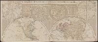
- Description:
- Cross collection no. 34., Double hemispherical map of the world showing countries, Dampier's voyage, winds, planetary systems, charts and appearance of the sun and moon. Relief shown pictorially., Imperfect: third name in imprint illegible. Hand col. Mounted on linen., Scale measured at center of hemisphere., and Shows California as an island.
- Publisher:
- Printed for I. Bowles ... Ca. Bowles ... and sold by [?] ... R. Sayer ... and Iohn King ...,
- Subject (Name):
- Bowles, Carington, 1724-1793, bookseller, Bowles, John, 1701-1779, bookseller, and Sayer, Robert, 1725-1794, bookseller
- Subject (Topic):
- World maps--Early works to 1800
- Found in:
- Beinecke Rare Book and Manuscript Library > A new and correct map of the world laid down according to the newest discoveries and from the most exact observations / [cartographic material] / by Herman Moll, geographer.

- Published / Created:
- 1737
- Call Number:
- 11 1737
- Container / Volume:
- BRBL_00681
- Image Count:
- 1
- Resource Type:
- Maps, Atlases & Globes
- Alternative Title:
- New and correct map of the world
- Description:
- Contains two hemispheres, with text on Newton's theory of tides and 2 smaller hemispheres of constellations at top, and ill. of the moon and other planets at middle and bottom., Imperfect: mutilated along folds, with some loss of text. Cross collection no. 35., and Relief is shown pictorially.
- Publisher:
- Printed for and sold by Geo. Foster ....,
- Subject (Name):
- Foster, George, fl. 1737-1739, bookseller
- Subject (Topic):
- World maps--Early works to 1800
- Found in:
- Beinecke Rare Book and Manuscript Library > A new and correct map of ye world [cartographic material] : laid down according to ye latest and best observations : to which is added several curious discourses on the tides, trade winds & monsoons ...

- Creator:
- Halley, Edmond, 1656-1742
- Published / Created:
- 1700
- Call Number:
- 11 1700
- Container / Volume:
- BRBL_00004
- Image Count:
- 1
- Resource Type:
- Maps, Atlases & Globes
- Alternative Title:
- New and correct sea chart of the whole world shewing the variations of the compass as they were found in the year MDCC and Nova et accuratissima totius terrarum orbis tabula nautica, variationum magneticarum index juxta observationes anno. 1700
- Description:
- Text at bottom: "Sold by R. & W. Mount and T. Page in Postern Row, Tower Hill".
- Publisher:
- Sold by R. Mount & T. Page ... ,
- Subject (Topic):
- World maps--Early works to 1800
- Found in:
- Beinecke Rare Book and Manuscript Library > Nova & accuratissima totius terrarum orbis tabula nautica, variationum magneticarum index juxta observationes anno. 1700 ... / per Edm: Halley ; I Harris sculp. = A new and correct sea chart of the whole world shewing the variations of the compass as they