Skip to search
Skip to main content
Skip to first result
Search
You Searched For
Resource Type
Maps, Atlases & Globes
Language
Japanese
New Search
Search Results
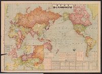
Published / Created:
1914
Call Number:
11 1914A
Container / Volume:
BRBL_00010
Image Count:
2
Resource Type:
Maps, Atlases & Globes
Description:
In Japenese. and Inset: Europe.
Publisher:
Horeikan,
Subject (Geographic):
World--maps
Found in:
Beinecke Rare Book and Manuscript Library > Sekai jikyoku, meisai dai chizu, [Map of the World]. Compiled by Chirichosa Kai.
Published / Created:
1845]
Call Number:
11 1845A
Container / Volume:
BRBL_00007
Image Count:
1
Resource Type:
Maps, Atlases & Globes
Description:
Map in Japanese. and Preliminary record.
Publisher:
[Published by Izumiya Kichibei and Maruya Gin (or Ginshishi),
Subject (Geographic):
World--maps
Found in:
Beinecke Rare Book and Manuscript Library > Shinsen Bankoku Jinbutsu Ichiran. [Newly Compiled Map of the World and drawn by Kochoen Shunshu]. Shiba, Shinmeimae, Yedo.
Creator:
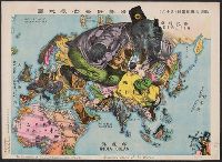
Published / Created:
[1914?]
Call Number:
13am 1914
Container / Volume:
BRBL_00011
Image Count:
1
Resource Type:
Maps, Atlases & Globes
Alternative Title:
Illustration of the Great European War.
Description:
"A humoros atlas of the world." and In Japanese and English.
Subject (Geographic):
Eastern Hemisphere--Maps
Subject (Topic):
World War, 1914-1918--Maps
Found in:
Beinecke Rare Book and Manuscript Library > The illustration of the Graet European War. No. 16.
Creator:
Published / Created:
1945
Call Number:
57 T578 1945A
Container / Volume:
BRBL_00304
Image Count:
1
Resource Type:
Maps, Atlases & Globes
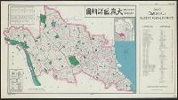
Alternative Title:
Ōmori-ku shōsaizu, Tōkyō, Ōmori-ku, guide to postal districts [cartographic material] = 大森區詳細圖., and 大森區詳細圖
Description:
"No. 34.", "No. 6234--R & A, OSS.", "Provisional edition.", In English and Japanese; place names in Japanese., and Includes index to ku and index map.
Publisher:
Reproduction Branch, OSS,
Subject (Name):
United States. Office of Strategic Services. Reproduction Branch
Subject (Topic):
Postal service--Japan--Tokyo--Maps
Found in:
Beinecke Rare Book and Manuscript Library > Tōkyō, Ōmori-ku, guide to postal districts = Ōmori-ku shōsaizu.
Published / Created:
1942?]
Call Number:
11hc 1942
Container / Volume:
BRBL_00010I
Image Count:
2
Resource Type:
Maps, Atlases & Globes
Description:
"Supplement to all dailies published by Manila Shinbun-sha"., English, Japanese., Imperfect: Mutilated, with some loss of text., Map on verso: Greater East Asia war and brilliant achievements., and Tables of Allied and Axis statistics on verso.
Subject (Topic):
World War, 1939-1945--Maps
Found in:
Beinecke Rare Book and Manuscript Library > Up-to-date map of the world war.
Published / Created:
1870
Call Number:
57 Y771 1870
Container / Volume:
BRBL_00304
Image Count:
2
Resource Type:
Maps, Atlases & Globes
Subject (Geographic):
Yokohama-shi (Japan)--Maps
Found in:
Beinecke Rare Book and Manuscript Library > Yokohama annai ezu [Illustrated guide to Yokohama, Japan].
Published / Created:
1945?]
Call Number:
289CBF 1945
Container / Volume:
BRBL_00027
Image Count:
3
Resource Type:
Maps, Atlases & Globes
Description:
In Japanese. and Title supplied by cataloger.
Subject (Geographic):
Leyte Island (Philippines)--Maps
Found in:
Beinecke Rare Book and Manuscript Library > [3 maps of Leyte Island, Philippines, in Japanese.]
Published / Created:
1945?]
Call Number:
281CBF 1945A
Container / Volume:
BRBL_00026
Image Count:
4
Resource Type:
Maps, Atlases & Globes
Description:
In Japanese. and Title supplied by cataloger.
Subject (Geographic):
Luzon (Philippines)--Maps
Found in:
Beinecke Rare Book and Manuscript Library > [4 maps of Luzon, Philippines, in Japanese.]
Published / Created:
1945?]
Call Number:
26cbf 1945
Container / Volume:
BRBL_00023A
Image Count:
1
Resource Type:
Maps, Atlases & Globes
Description:
Shows part of Northern Territory and Papua New Guinea.
Subject (Geographic):
Arafura Sea--Maps
Found in:
Beinecke Rare Book and Manuscript Library > [Map of Arafura Sea, in Japanese].
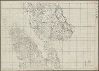
Published / Created:
[189x?]
Call Number:
Lanman Covers 56 189x
Image Count:
2
Resource Type:
Maps, Atlases & Globes
Description:
In Japanese., Japanese reprint of a Chinese map published in 1663., and Transliteration supplied by cataloger.
Publisher:
Umemura Yahaku,
Subject (Geographic):
China--Maps.
Found in:
Beinecke Rare Book and Manuscript Library > [Map of China].
Branch:v1.61.8 ,Deployed:2024-06-20T11:15:04-04:00