Skip to search
Skip to main content
Skip to first result
Search
You Searched For
Resource Type
Maps, Atlases & Globes
New Search
Search Results
Published / Created:
1840-1844.
Call Number:
23 1844
Container / Volume:
BRBL_00020
Image Count:
3
Resource Type:
Maps, Atlases & Globes
Description:
Islands of Fakaafo or Bowditch ca. 1:300,000; Nuku-Nono or Duke of Clarence 1:75,000; Oatáfu or Duke of York 1:75,000; Swains, Jarvis, Birnies, Enderbury, Hull, New York or Washington all ca. 1:75,000; Funafuti or Ellices, Nukufetau o and Preliminary record.
Subject (Geographic):
Oceania--Maps
Found in:
Beinecke Rare Book and Manuscript Library > [U.S. Exploring Expedition Pacific Ocean] Engraved by Sherman and Smith, New York. By the U.S. Ex.Ex.
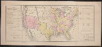
Published / Created:
1848?]
Call Number:
75 1848C
Container / Volume:
BRBL_00399
Image Count:
1
Resource Type:
Maps, Atlases & Globes
Description:
Prepared for the President of the United States ...
Subject (Geographic):
United States--Maps
Found in:
Beinecke Rare Book and Manuscript Library > [United States Treaties] E. Gilman, draftsman. P.S. Duval's Steam lith. press, Philadelphia.
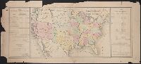
Published / Created:
1848?]
Call Number:
75 1848B
Container / Volume:
BRBL_00399
Image Count:
1
Resource Type:
Maps, Atlases & Globes
Subject (Geographic):
United States--Maps
Found in:
Beinecke Rare Book and Manuscript Library > [United States Treaties] E. Gilman, draftsman. P.S. Duval's Steam lith. press, Philadelphia.
Published / Created:
1866
Call Number:
75 1866H
Container / Volume:
BRBL_00403
Image Count:
1
Resource Type:
Maps, Atlases & Globes
Publisher:
U.S. Coast Survey Office,
Subject (Geographic):
United States--Maps
Found in:
Beinecke Rare Book and Manuscript Library > [United States] / drawn by A. Lindenkohl ; Chas. G. Krebs, Litho.
Published / Created:
[1920?].
Call Number:
75 1920
Container / Volume:
BRBL_00407A
Image Count:
2
Resource Type:
Maps, Atlases & Globes
Description:
Various information on borders; shows time zones. and Verso: Central part city of Washington and other data, etc.
Publisher:
Rand, McNally & Co.,
Subject (Geographic):
United States--Maps
Found in:
Beinecke Rare Book and Manuscript Library > [United States] / printed by Rand McNally & Company for free distribution through the newspapers represented by Frederic J. Haskin ; photographs by Harris & Ewing.
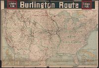
Published / Created:
c1902.
Call Number:
75gme 1915
Container / Volume:
BRBL_00414A
Image Count:
1
Resource Type:
Maps, Atlases & Globes
Description:
Insets of U.S. Possessions.
Publisher:
Poole Bros.,
Subject (Geographic):
United States--Maps
Found in:
Beinecke Rare Book and Manuscript Library > [United States] Burlington Route / Burlington R.R.
Published / Created:
[1808]
Call Number:
In W890 Zz808
Collection Title:
The history of the rise, progress, and accomplishment of the abolition of the African slave-trade
Image Count:
1
Resource Type:
Maps, Atlases & Globes
Description:
Autographed presentation copy to Mrs. Elizabeth Cookson from S.T. Coleridge; on fly-leaf at front of v.1 is Mrs. Wordsworths manuscript copy of her husbands sonnet, "To Thos. Clarkson, on the final passing of the bill for the abol and Folded map facing p. 259
Subject (Topic):
Slave trade. and Slavery
Collection Created:
London : Longman, Hurst, Rees, and Orme, 1808
Found in:
Beinecke Rare Book and Manuscript Library > [Untitled map of abolition of the slave trade]
Creator:
Published / Created:
[1739?]
Call Number:
1973 folio 44
Collection Title:
Plan de Paris commence l’annee 1734. Dessine et gravesous les ordres de Messire Michel Etienne
Image Count:
1
Resource Type:
Maps, Atlases & Globes
Description:
Consists of 20 numbered sectional plans of Paris. and Scale about 1:1800.
Subject (Geographic):
Paris (France) --Maps
Subject (Topic):
Architecture --France --Paris
Collection Created:
[Paris? 1739?]
Found in:
Beinecke Rare Book and Manuscript Library > [Untitled sectional plan of Paris]
Creator:
Published / Created:
[1739?]
Call Number:
1973 folio 44
Collection Title:
Plan de Paris commence l’annee 1734. Dessine et grave sous les ordres de Messire Michel Etienne
Image Count:
1
Resource Type:
Maps, Atlases & Globes
Description:
Consists of 20 numbered sectional plans of Paris. and Scale about 1:1800.
Subject (Geographic):
Jardin des Tuileries (Paris, France), Paris (France) --Maps, and Tuileries Palace (Paris, France)
Subject (Topic):
Architecture --France --Paris
Collection Created:
[Paris? 1739?]
Found in:
Beinecke Rare Book and Manuscript Library > [Untitled sectional plan of Paris]
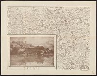
Published / Created:
1916?].
Call Number:
38 V58 1916
Container / Volume:
BRBL_00166
Image Count:
1
Resource Type:
Maps, Atlases & Globes
Description:
In bottom right margin: "Cliché dell'Officina Romana." and Inset view of Verdun.
Publisher:
s.n.,
Subject (Geographic):
Verdun (France)--Maps
Found in:
Beinecke Rare Book and Manuscript Library > [Verdun and Environs].
Branch:v1.61.6 ,Deployed:2024-06-12T09:55:36-04:00