Partie de l'Amérique septent[rionale] qui comprend la Nouvelle France ou le Canada
Description:
"Avec privilege 1755.", "C. Haussard sculp.", "Wm. Inglis Morse Collection" -- on recto in upper right corner. Stamp on verso: Canada. No. on verso: 103., From the author's Atlas universel. 1757[-1758]., Inset of "Supplement pour les lacs du Canada." Scale [ca. 1:5,500,000]., Relief shown pictorially., Second state, with "I. Charlton" in James Bay named and the location and orientation of "F. de la Presqu'íle" changed., and Watermark.
Publisher:
s.n.,
Subject (Geographic):
Canada--Maps--Early works to 1800., Great Lakes Region (North America)--Maps--Early works to 1800., and New France--Maps--Early works to 1800.
Subject (Name):
George Washington's American Atlas., Haussard, Catherine, engraver., Morse, William Inglis,--b. 1874--Stamp., Robert de Vaugondy, Gilles, 1688-1766. Atlas universel., and Washington, George,--1732-1799--Ownership.
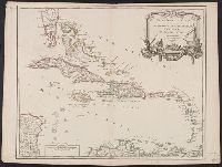
Cross Collection no. 249., From Robert de Vaugondy's Atlas universel. Paris : Chez les auteurs, quay de l'Horloge du Palais, Boudet libraire imprimeur du roi, ruë St. Jacques, 1757., Ornamental cartouche., Relief shown pictorially., Scale in "Milles pas géometriques" and "lieues marines de 20 au degré.", Second state, with cardinal points outside of graticule., and Stamped title and no. "109" on verso.
Publisher:
Gilles Robert de Vaugondy],
Subject (Geographic):
West Indies--Maps--Early works to 1800
Subject (Name):
Haye, G. de la., engraver, Robert de Vaugondy, Didier, 1723-1786, and Robert de Vaugondy, Gilles, 1688-1766. Atlas universel
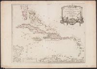
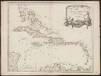
Cross Collection no. 251., From Robert de Vaugondy's Atlas universel. Paris : Chez les auteurs, quay de l'Horloge du Palais, Boudet libraire imprimeur du roi, ruë St. Jacques, 1757., Imperfect: small hole in "Hispanola ou Saint Domingue," with no loss of text., Ornamental cartouche., Relief shown pictorially., Scale in "Milles pas géometriques" and "lieues marines de 20 au degré.", Second state, with cardinal points outside of graticule., and Stamped no. on verso: 107.
Publisher:
Gilles Robert de Vaugondy],
Subject (Geographic):
West Indies--Maps--Early works to 1800
Subject (Name):
Haye, G. de la., engraver, Robert de Vaugondy, Didier, 1723-1786, and Robert de Vaugondy, Gilles, 1688-1766. Atlas universel
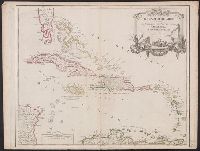
Cross Collection no. 250., From Robert de Vaugondy's Atlas universel. Paris : Chez les auteurs, quay de l'Horloge du Palais, Boudet libraire imprimeur du roi, ruë St. Jacques, 1757., Ornamental cartouche., Relief shown pictorially., Scale in "Milles pas géometriques" and "lieues marines de 20 au degré.", Second state, with cardinal points outside of graticule., and Stamped title and no. "102" on verso.
Publisher:
Gilles Robert de Vaugondy],
Subject (Geographic):
West Indies--Maps--Early works to 1800
Subject (Name):
Haye, G. de la., engraver, Robert de Vaugondy, Didier, 1723-1786, and Robert de Vaugondy, Gilles, 1688-1766. Atlas universel
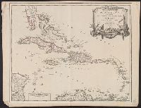
Cross Collection no. 252., From Robert de Vaugondy's Atlas universel. Paris : Chez les auteurs, quay de l'Horloge du Palais, Boudet libraire imprimeur du roi, ruë St. Jacques, 1757., Hand col., Ornamental cartouche., Relief shown pictorially., Scale in "Milles pas géometriques" and "lieues marines de 20 au degré.", Second state, with cardinal points outside of graticule., and Stamped title on verso. Ms. no. on verso: 102.
Publisher:
Gilles Robert de Vaugondy],
Subject (Geographic):
West Indies--Maps--Early works to 1800
Subject (Name):
Haye, G. de la., engraver, Robert de Vaugondy, Didier, 1723-1786, and Robert de Vaugondy, Gilles, 1688-1766. Atlas universel
From Robert de Vaugondy's Atlas universel. Paris : Chez les auteurs, quay de l'Horloge du Palais, Boudet libraire imprimeur du roi, ruë St. Jacques, 1757., Ornamental cartouche., Relief shown pictorially., Scale in "Milles pas géometriques" and "lieues marines de 20 au degré.", Second state, with cardinal points outside of graticule., and Sheet measures 51.5 x 69.1 cm. Stamped title on verso.
Publisher:
Gilles Robert de Vaugondy],
Subject (Geographic):
West Indies--Maps--Early works to 1800
Subject (Name):
Haye, G. de la., engraver, Robert de Vaugondy, Didier, 1723-1786, and Robert de Vaugondy, Gilles, 1688-1766. Atlas universel
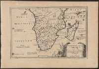
Histoire et description generale de la Nouvelle France
Container / Volume:
BRBL_00731
Image Count:
1
Resource Type:
Maps, Atlases & Globes
Description:
Lower left corner: 34., Prime meridian: Paris., Sheet measures 23 x 46 cm. Franklin Collection., and Watermark.
Publisher:
Pierre-François Giffart],
Subject (Geographic):
Alabama--Maps--Early works to 1800, Florida--Maps--Early works to 1800, Gulf Coast (U.S.)--Maps--Early works to 1800, Louisiana--Maps--Early works to 1800, and Mobile Bay (Ala.)--Maps--Early works to 1800
Subject (Name):
Charlevoix, Pierre-François-Xavier de, 1682-1761 and Giffart, Pierre François, 1677-1758
Subject (Topic):
Coasts--Alabama--Maps--Early works to 1800, Coasts--Florida--Maps--Early works to 1800, and Coasts--Louisiana--Maps--Early works to 1800
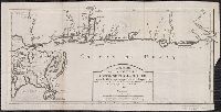
Includes text regarding first European discoveries., Relief shown pictorially., and Yale copy accompanied by: Description du fameux Cap de Bonne Esperance / par N. de Fer. -- 1 leaf ; 28 x 40 cm.
"Longitude du meridien de l'Isle de Fer.", Appears in Bellin's Atlas maritime., and Ms. notes on verso. Hand col. Sheet measures 57.3 x 79.8 cm. Cross Collection no. 168.
Publisher:
Dépot de la Marine],
Subject (Geographic):
Canada--Maps--Early works to 1800
Subject (Name):
Bellin, Jacques Nicolas, 1703-1772. Atlas maritime
"Longitude du meridien de l'Isle de Fer.", Appears in Bellin's Atlas maritime., and Stamp: Thorne Collection of Cartogaphy and Geography. Stamp: Karpinski-von Wieser Map Collection. "159"--Manuscript note.
Publisher:
Dépot de la Marine],
Subject (Geographic):
Canada--Maps--Early works to 1800
Subject (Name):
Bellin, Jacques Nicolas, 1703-1772. Atlas maritime and Thorne Collection of Cartogaphy and Geography Stamp