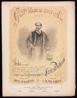
"Ent. according to Act of Congress in the year 1868.", For voice and piano., Passage from A Christmas carol quoted on t.p., and Two-color lithographic portrait of Dickens on t.p.
Publisher:
Wm. A. Pond & Co.,
Subject (Name):
Cooper, George, 1840-1927 and Dickens, Charles, 1812-1870. Christmas carol
Map of the great railroad routes from the Middle Atlantic ports to the Mississippi River., Map of the railroads of New England and eastern N. York., and Map of the United States & Canada
Description:
Includes statistical charts: Population of the United States (by state and territory, 1790-1860) -- Ratio of slaves to total population -- Positions of forts., Insets: Map of the great railroad routes fr, Prime meridian: Greenwich., and Relief shown by hachures.
Publisher:
G.Q. Colton,
Subject (Geographic):
Canada--Maps and United States--Maps
Subject (Topic):
Railroads--New England--Maps, Railroads--New York (State)--Maps, and Railroads--United States--Maps
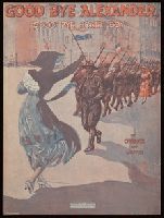
For medium or high voice and piano., Illustrated t.p. signed: E.E. Walton., and Publishers advertisement on p. [4].
Publisher:
Broadway Music Corp.,
Subject (Name):
Creamer, Henry, 1879-1930. and Walton, E. E.
Subject (Topic):
African American soldiers--Songs and music., African Americans--Songs and music., Popular music--1911-1920., Songs (High voice) with piano., Songs (Medium voice) with piano., and World War, 1914-1918--United States--Songs and music.
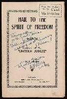
From the collection of Carl Van Vechten., Individual parts for orchestra with piano., and Inscribed for Carl Van Vechten by William Christopher Handy, 7-8-1941.
Publisher:
Handy bros. music co., inc.,
Subject (Name):
Handy, W. C.--(William Christopher),--1873-1958--Presentation inscription to C. Van Vechten. and Van Vechten, Carl, 1880-1964--Presentation inscription from W.C. Handy
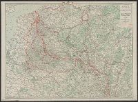
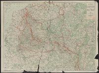
Hammond's large scale war map Italian Front, War map Italian Front, and War map of the Western Front
Description:
Both maps show battle lines as of Sept. 23rd, 1918., Copy 1: Printed on linen., Maps show railways, canals, forests, aircraft depots, wireless stations, forts, fortified towns, and nava, and Possibly issued with an index, which is no longer present.
Publisher:
C.S. Hammond & Co. (Incorporated) Engravers, Printers, Publishers 30 Church Street (Hudson Terminal),
Subject (Geographic):
Europe, Western--Maps and Italy--Maps
Subject (Topic):
World War, 1914-1918--Campaigns--Italy--Maps and World War, 1914-1918--Campaigns--Western Front--Maps
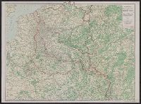
Hammond's large scale war map Italian Front, War map Italian Front, and War map of the Western Front
Description:
Both maps show battle lines as of Sept. 23rd, 1918., Maps show railways, canals, forests, aircraft depots, wireless stations, forts, fortified towns, and naval arsenals, etc., and Possibly issued with an index, which is no longer present.
Publisher:
C.S. Hammond & Co. (Incorporated) Engravers, Printers, Publishers 30 Church Street (Hudson Terminal),
Subject (Geographic):
Europe, Western--Maps and Italy--Maps
Subject (Topic):
World War, 1914-1918--Campaigns--Italy--Maps and World War, 1914-1918--Campaigns--Western Front--Maps
Relief shown by spot heights. and Shows "Furthest advance of the German Army," "Battle line August 15th, 1917," railways, canals, forests and woods, aircraft depots, wireless stations, forts and redoubts and fortresses, fortified towns and naval arsenals.
Publisher:
C.S. Hammond,
Subject (Geographic):
Europe, Western--Maps
Subject (Topic):
World War, 1914-1918--Campaigns--Western Front--Maps