40 1838A: Stamp: Fürstlich Oettingen-Wallerstein'sche Bibliothek in Seyfriedsberg., In Italian and German. Legend in Italian, German and French., Includes tables, text, and Shows detailed postal route information between Marseille, Augsburg, Warsaw, and Naples.
Publisher:
Poste nelle Prove. Venete,
Subject (Geographic):
France, Germany, and Italy--Maps
Subject (Name):
Botte, Antonio Federico and Fürstlich Oettingen-Wallerstein'sche Bibliothek in Seyfriedsberg Stamp
Subject (Topic):
Post roads--France--Maps, Post roads--Germany--Maps, Post roads--Italy--Maps, Postal service--France--Maps, Postal service--Germany--Maps, and Postal service--Italy--Maps
Kaiserlich-Königliches Militärgeographisches Institut zu Mailand
Published / Created:
[1838?]
Call Number:
40 1838
Container / Volume:
BRBL_00200
Image Count:
4
Resource Type:
Maps, Atlases & Globes
Alternative Title:
Carta generale del Regno Lombardo-Veneto
Description:
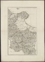
On 4 sheets; dissected and mounted on linen. Imperfect: 2 sheets comprising northern section wanting; mutilated with loss of text. Area map affixed to verso of each sheet. and Relief shown by hachures.
Publisher:
Das Institut,
Subject (Geographic):
Lombardo-Venetian Kingdom--Maps, Lombardy (Italy)--Maps, and Veneto (Italy
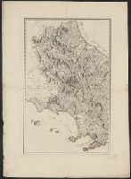
"K. Ponheimer sc. Viennae"--Below lower right corner., "Karpinski-von Wieser Map Collection"--Stamp., "N. 72. A"--Above upper right corner., In Italian and German., Relief shown pictorially., and Title devised by cataloger.
Subject (Geographic):
Italy, Southern--Maps
Subject (Name):
Ponheimer, Kil. (Kilian) engraver and Reilly, Franz J. J. von
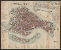
In Italian and German., Includes indices and notes., Inset: Lagune Venete = Venedigs Lagunen von dem Dämmen des Sile bis zur Mündung der Etsch., and Relief shown by hachures.
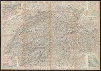
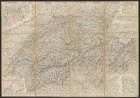
Carta stradale della Svizzera, Carte routière de la Suisse, Reisekarte der Schweiz, and Road map of Switzerland
Description:
In French. Legend and scales in French, English, German, and Italian., Includes insets of northwestern Europe, north-central Europe, northern Italy, and the French-Italian coastal, and Mounted on verso: Luzern -- Bâle -- Genève -- Zuric -- Berne -- Lausanne.
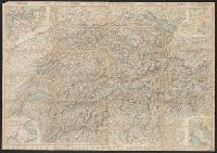
Carta stradale della Svizzera, Carte routière de la Suisse, Reisekarte der Schweiz, and Road map of Switzerland
Description:
In French. Legend and scales in French, English, German, and Italian., Includes insets of northwestern Europe, north-central Europe, northern Italy, and the French-Italian coastal region., Mounted on verso: Luzern, and Relief shown by hachures and spot heights.
Carta stradale della Svizzera, Carte routière de la Suisse, Reisekarte der Schweiz, and Road map of Switzerland
Description:
In French. Legend and scales in French, English, German, and Italian., Includes insets of northwestern Europe, north-central Europe, northern Italy, and the French-Italian coastal region., Library copy annotated in, and Relief shown by hachures and spot heights.