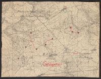
Accompanied by sheet containing overlay diagrams "Sperrfeuer Remenauville" and "Sperrfeuer: Mort-Mare-Wald". and Ms. annotations in German. Imperfect: cut around borders.
Publisher:
s.n.,
Subject (Geographic):
Champagne-Ardenne (France)--Maps and Lorraine (France)--Maps
Subject (Topic):
Electric lines, Telephone lines, World War, 1914-1918--France--Lorraine, and World War, 1914-1918--Maps
Karpinskiĭ, A. P. (Aleksandr Petrovich), 1846-1936
Published / Created:
1884
Call Number:
352ca Ur1 1884
Container / Volume:
BRBL_00109
Image Count:
3
Resource Type:
Maps, Atlases & Globes
Alternative Title:
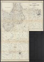
Geologische Karte des Ostabhanges des Urals
Description:
Includes 2 inset maps: "Geologicheskai︠a︡ karta okrestnosteĭ S. Smolina" and "Geologicheskai︠a︡ karta dachi kamenskago zavoda.", Longitudinal coordinates shown on map are based on Pulkova., and Russian and German.
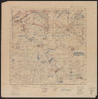
"Abgeschlossen am 18.7.18"., In upper right margin: Bl. 142, Bernécourt., Legend indicates trench information in red and blue ink., and Ms. annotations in German indicating trench information.
Publisher:
s.n.,
Subject (Geographic):
Lorraine (France)--Military maps
Subject (Topic):
World War, 1914-1918--France--Lorraine and World War, 1914-1918--Maps
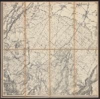
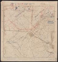
Legend indicates trench information in red and blue ink., Northeast, northwest, and southwest corners of Bl. 142, Bernécourt., and Northeastern sheet: "Abgeschlossen am 10.6.18"; Northwestern sheet: "Abgeschlossen am 20.5.18"; Southwestern sheet: "Abgeschlosse am 20.5.18"; Southwestern sheet: "Abgeschlossen am 17.6.18".
Publisher:
s.n.,
Subject (Geographic):
Lorraine (France)--Military maps
Subject (Topic):
World War, 1914-1918--France--Lorraine and World War, 1914-1918--Maps