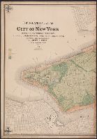
1. Topographical atlas of the City of New York including the annexed territory, showing original water Creator: Viele, Egbert L. (Egbert Ludovicus), 1825-1902 Published / Created: 1874 Call Number: 771 N49 1874 Container / Volume: BRBL_00488 Image Count: 5 Resource Type: Maps, Atlases & Globes Found in: Beinecke Rare Book and Manuscript Library > Topographical atlas of the City of New York including the annexed territory, showing original water courses and made land / prepared under the direction of Egbert L. Viele ; Eugene Quackenbush ; Julius Bien photo lith.
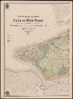
2. Topographical atlas of the City of New York including the annexed territory, showing original water Creator: Viele, Egbert L. (Egbert Ludovicus), 1825-1902 Published / Created: 1874 Call Number: 771 N49 1874 Container / Volume: BRBL_00488 Image Count: 5 Resource Type: Maps, Atlases & Globes Found in: Beinecke Rare Book and Manuscript Library > Topographical atlas of the City of New York including the annexed territory, showing original water courses and made land / prepared under the direction of Egbert L. Viele ; Eugene Quackenbush ; Julius Bien photo lith.