... Iohn Hvighen van Linschoten. his Discours of Voyages into ye Easte & West Indies. Deuided into
Image Count:
1
Description:
[Scale ca. 1:13,500,000]., Bound in following p. 316., In ink on verso: "p. 8" crossed out in ink with two lines., In pencil on verso: 211., and Map has one black ink mark that can be seen on both the recto and verso.
Subject (Geographic):
Africa --Maps --Early works to 1800, Africa, East --Maps, and Madagascar --Maps --Early works to 1800
Subject (Topic):
Voyages and travels --Early works to 1800
Collection Created:
Printed at London by Iohn Wolfe Printer to ye Honorable Cittie of London [1598]
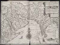
Navigatio ac itinerarivm Iohannis Hvgonis Linscotani in Orientalem sive Lvsitanorvm Indiam
Image Count:
1
Description:
[Scale ca. 1:13,500,000]., Bound in following page 12., Map has significant tear along bottom center fold and one tear at bottom left portion., and Some ink from place names have bled through to the verso.
Subject (Geographic):
Afghanistan --Maps, Egypt --Maps --Early works to 1800, India --Maps, Iran --Maps --Early works to 1800, Iraq --Maps, Pakistan --Maps, and Saudi Arabia --Maps
Subject (Name):
Claesz, Cornelis, ca. 1546-1609, publisher, Elzevier, Gillis, bookseller, Hendricksz, Aelbrecht, fl. 1573-1605, printer, and Langren, Arnold Florent van, 1580-1644
Subject (Topic):
Voyages and travels --Early works to 1800
Collection Created:
Hagae-Comitis : Ex officina Alberti Henrici, impensis authoris & Cornelii Nicolai, prostantque apud Aegidium Elseuirum, anno 1599
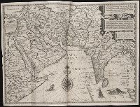
Nauigatio ac itinerarium Iohannis Hugonis Linscotani in Orientalem siue Lusitanorum Indiam
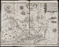
Image Count:
1
Description:
[Scale ca. 1:13,500,000]., Bound in following page 14., In pencil on middle left panel of left verso: 13-1., In pencil on middle left panel of right verso: 13., and Map has small tear along top center fold.
Subject (Geographic):
Afghanistan --Maps, Egypt --Maps --Early works to 1800, India --Maps, Iran --Maps --Early works to 1800, Iraq --Maps, Pakistan --Maps, and Saudi Arabia --Maps
Subject (Name):
Claesz, Cornelis, ca. 1546-1609, publisher, Elzevier, Gillis, bookseller, and Hendricksz, Aelbrecht, fl. 1573-1605, printer
Subject (Topic):
Voyages and travels --Early works to 1800
Collection Created:
Hagae-Comitis : Ex officina Alberti Henrici, impensis authoris & Cornelii Nicolai, prostantque apud Aegidium Elseuirum, anno 1599
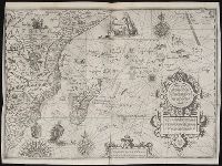
... Iohn Hvighen van Linschoten. his Discours of Voyages into ye Easte & West Indies. Deuided into
Image Count:
1
Description:
[Scale ca. 1:13,500,000]., Bound in following title page of book three., In ink on verso: "10" crossed out in ink with two lines., In ink on verso: 307., In ink on vesro: X., and Map properly belongs to the Dutch edition of 1596.
Subject (Geographic):
Africa --Maps --Early works to 1800, Arabian Peninsula --Maps --Early works to 1800, Arabian Sea --Charts, maps, etc., Armenia (Republic) --Maps, Asia --Maps --Early works to 1800, Bengal, Bay of --Maps, Cyprus --Maps --Early works to 1800, India --Maps --Early works to 1800, Mediterranean Sea --Maps --Early works to 1800, Syria --Maps, Tigris River Valley, and Yemen --Maps --Early works to 1800
Subject (Topic):
Voyages and travels --Early works to 1800
Collection Created:
Printed at London by Iohn Wolfe Printer to ye Honorable Cittie of London [1598]
Langren, Henricus F. ab (Henricus Florentius), ca. 1574-1648
Published / Created:
1595
Call Number:
Z3 017
Collection Title:
John Huighen van Linschoten, his Discours of Voyages into ye Easte & West Indies
Image Count:
1
Description:
[Scale ca. 1:13,500,000]., Bound in following p. 32., Map has some small tears along fold lines., and Map properly belongs to the Dutch edition of 1596.
Subject (Geographic):
Borneo --Maps --Early works to 1800, China --Maps --1368-1644, Japan --Maps --Early works to 1800, Java (Indonesia) --Maps --Early works to 1800, and Sumatra (Indonesia) --Maps
Subject (Topic):
Voyages and travels --Early works to 1800
Collection Created:
[London] : Printed at London by [John Windet for] Iohn Wolfe, printer to ye Honorable Cittie of London, [1598]
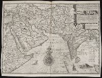
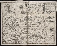
Navigatio ac itinerarivm Iohannis Hvgonis Linscotani in Orientalem sive Lvsitanorvm Indiam
Image Count:
1
Description:
[Scale ca. 1:13,500,000]., Bound in following page 22., Map has several areas of small brown and yellow stains on the recto as well as two areas of linear white chalky lines on the verso; one forms a cross., and Map has significant tear along bottom center fold.
Subject (Geographic):
Borneo --Maps, China --Maps --Early works to 1800, Indonesia --Maps, Japan --Maps --Early works to 1800, Java (Indonesia) --Maps --Early works to 1800, and Philippines --Maps
Subject (Name):
Claesz, Cornelis, ca. 1546-1609, publisher, Elzevier, Gillis, bookseller, Hendricksz, Aelbrecht, fl. 1573-1605, printer, and Langren, Arnold Florent van, 1580-1644
Subject (Topic):
Voyages and travels --Early works to 1800
Collection Created:
Hagae-Comitis : Ex officina Alberti Henrici, impensis authoris & Cornelii Nicolai, prostantque apud Aegidium Elseuirum, anno 1599
Nauigatio ac itinerarium Iohannis Hugonis Linscotani in Orientalem siue Lusitanorum Indiam
Image Count:
1
Description:
[Scale ca. 1:13,500,000]., Bound in following page 22., In pencil on middle left panel of left verso: 23., In pencil on middle right panel of left verso: 22-1., and Map has several areas of staining most noticeably along the top verso.
Subject (Geographic):
Borneo --Maps, China --Maps --Early works to 1800, Indonesia --Maps, Japan --Maps --Early works to 1800, Java (Indonesia) --Maps --Early works to 1800, and Philippines --Maps
Subject (Name):
Claesz, Cornelis, ca. 1546-1609, publisher, Elzevier, Gillis, bookseller, and Hendricksz, Aelbrecht, fl. 1573-1605, printer
Subject (Topic):
Voyages and travels --Early works to 1800
Collection Created:
Hagae-Comitis : Ex officina Alberti Henrici, impensis authoris & Cornelii Nicolai, prostantque apud Aegidium Elseuirum, anno 1599
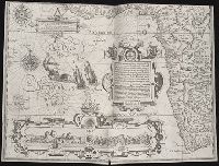
Descriptio ac delineatio geographica detectionis freti, sive, transitus ad occasum supra terras
Image Count:
1
Abstract:
Map depicts the Coat of Arms of the United Kingdom (era of the Union of the Crowns), reigning between the years 1603-1707.
Alternative Title:
Tabula nautica, qua repraesentantur orae maritimae, meatus, ac freta, noviter a H. Hudsono Anglo ad Caurum supra Novam Franciam
Description:
Bound in after p. [2]., In pencil on recto: 170., Map cut and folded irregularly., Map has multiple small stains on both the recto and verso., and Scale [ca. 1:9,000,000].
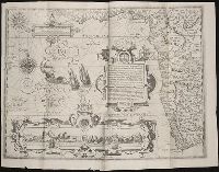
Nauigatio ac itinerarium Iohannis Hugonis Linscotani in Orientalem siue Lusitanorum Indiam
Image Count:
1
Description:
[Scale ca. 1:13,000,000]., Bound in following title page of "Descriptio totius Guineae tractus ...", In ink on top left panel of left verso: 3., and Map has several small tears now repaired on verso.
Subject (Geographic):
Africa, West --Maps --Early works to 1800
Subject (Name):
Claesz, Cornelis, ca. 1546-1609, publisher, Elzevier, Gillis, bookseller, and Hendricksz, Aelbrecht, fl. 1573-1605, printer
Subject (Topic):
Voyages and travels --Early works to 1800
Collection Created:
Hagae-Comitis : Ex officina Alberti Henrici, impensis authoris & Cornelii Nicolai, prostantque apud Aegidium Elseuirum, anno 1599