Search
You Searched For
Search Results
- Creator:
- Bellin, Jacques Nicolas, 1703-1772
- Published / Created:
- 1764
- Call Number:
- 85 1764
- Container / Volume:
- BRBL_00693
- Image Count:
- 1
- Resource Type:
- Maps, Atlases & Globes
- Found in:
- Beinecke Rare Book and Manuscript Library > Carte reduite des costes de la Louisiane et de la Floride / [cartographic material] / dressée au Dépost des cartes, plans et journaux de la Marine pour le service des vaisseaux du roy par ordre de M. Le Duc de Choisel, colonel général des Suisses et G
- Published / Created:
- 1851].
- Call Number:
- 11cfk 1850B-3
- Container / Volume:
- BRBL_00770
- Image Count:
- 1
- Resource Type:
- Maps, Atlases & Globes
- Found in:
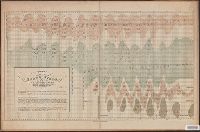
- Beinecke Rare Book and Manuscript Library > Chart Of The North East Trade Winds [cartographic material] / National Observatory.
- Creator:
- Sherman & Smith
- Published / Created:
- 1874?]
- Call Number:
- 19cea 1874
- Container / Volume:
- BRBL_00013
- Image Count:
- 1
- Resource Type:
- Maps, Atlases & Globes
- Found in:
- Beinecke Rare Book and Manuscript Library > Chart of the Antarctic continent : shewing the icy barrier attached to it, discovered by the U.S. Ex. Ex., Charles Wilkes, Esq., Commander, 1840.
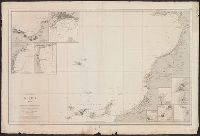
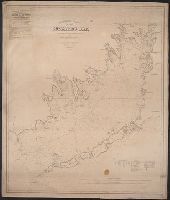
- Creator:
- Faden, William, 1749-1836
Palmer, W. (William), 1739-1812
Roberts, Henry, Lieut
- Published / Created:
- 1784
- Call Number:
- 23 1784
- Container / Volume:
- BRBL_00019
- Image Count:
- 1
- Resource Type:
- Maps, Atlases & Globes
- Found in:
- Beinecke Rare Book and Manuscript Library > Chart of the N.W. coast of America and the N.E. coast of Asia, explored in the years 1778 and 1779 / prepared by Lieut. Heny. Roberts, under the immediate inspection of Capt. Cook ; engraved by W. Palmer.
- Published / Created:
- 1902
- Call Number:
- 67 1902
- Container / Volume:
- BRBL_00348
- Image Count:
- 1
- Resource Type:
- Maps, Atlases & Globes
- Found in:
- Beinecke Rare Book and Manuscript Library > Costa Occidental de Africa. Hoja I. Comprende desde cabo de San Vicente hasta Cabo Yuby. Con inclusion de las islas Canarias y de Madera.
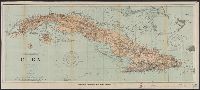
- Creator:
- Carvalho, Manoel Lourenço Vasco de
- Published / Created:
- 1890
- Call Number:
- BrSides Folio 2019 5
- Image Count:
- 1
- Resource Type:
- Maps, Atlases & Globes
- Found in:
- Beinecke Rare Book and Manuscript Library > Costa oriental d'Africa, provincia de Moçambique plano hydrographico da barra e porto do Rio Chinde / levantado de junho a agosto de 1889, sob a direccão do commandante da canhoneira Liberal Manoel Lourenço Vasco de Carvalho pelos officiaes da armada L. C
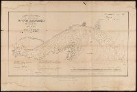
- Creator:
- U.S. Coast and Geodetic Survey
- Published / Created:
- 1898
- Call Number:
- 855hc 1898Q
- Container / Volume:
- BRBL_00765
- Image Count:
- 1
- Resource Type:
- Maps, Atlases & Globes
- Found in:
- Beinecke Rare Book and Manuscript Library > Cuba : part of chart "E" / Treasury Department, U.S. Coast and Geodetic Survey, Henry S. Pritchett, Superintendent.
- Published / Created:
- 1880
- Call Number:
- 754cea B98 1880
- Container / Volume:
- BRBL_00418
- Image Count:
- 2
- Resource Type:
- Maps, Atlases & Globes
- Found in:
- Beinecke Rare Book and Manuscript Library > Eldridge's chart no. 10 : Buzzard's Bay, from the United States Coast and George Eldridge's surveys / published by Thaxter & Son. 125 State St. Boston, 1880.
- Creator:
- Eldridge, George, 1821-1879
- Published / Created:
- 1891
- Call Number:
- 764cea B65 1891E
- Container / Volume:
- BRBL_00461
- Image Count:
- 1
- Resource Type:
- Maps, Atlases & Globes
- Found in:
- Beinecke Rare Book and Manuscript Library > Eldridge's new chart of Boston Harbor : compiled from the latest surveys / engraved by G.W. Boynton.
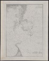
- Creator:
- United States Coast Survey
- Published / Created:
- 1883
- Call Number:
- 7645cea 1883
- Container / Volume:
- BRBL_00463
- Image Count:
- 1
- Resource Type:
- Maps, Atlases & Globes
- Found in:
- Beinecke Rare Book and Manuscript Library > Entrance to Nantucket Sound / United States Coast Survey.