Don Quixote. English and History of Don-Qvichote : the second parte ...
Description:
BEIN 1976 2616: With the bookplates of Francis Joseph Hogan and Charles J. Rosenbloom., First edition of the 2nd part., Signatures: [a]1A-Ii8Kk4(Kk4 blank)., and Translation ascribed to Thomas Shelton, who translated the first part.
Publisher:
Printed for Edward Blount,
Subject (Name):
Hogan, Francis Joseph,--1877-1944--Bookplate and Rosenbloom, Charles J.--Bookplate
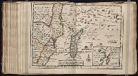
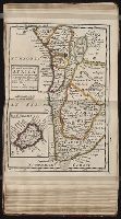
Twenty four new and accurate maps of the several parts of Europe ... : all (except the last) new
Image Count:
1
Alternative Title:
The south-east part of Germany, viz. Bavaria, Newburgh, Saltzburgh, Bohemia, Moravia, Austria, Styria, Carinthia, Carniola, Brixen, Trent, Tirol, &c
Description:
In pencil on verso: 10.
Subject (Geographic):
Austria --Maps --Early works to 1800, Bavaria (Germany) --Maps --Early works to 1800, Bohemia and Moravia (Protectorate, 1939-1945), Germany --Maps --Early works to 1800, and Styria (Austria) --Maps
Subject (Name):
Barker, B. (Benjamin), d. 1764, bookseller, Clements, Henry, d. 1719, bookseller, King, Charles, d. 1735, bookseller, Nicholson, John, d. ca. 1717, bookseller, Parker, Richard, fl. 1692-1725, bookseller, and Tooke, Benjamin, d. 1716, bookseller
Subject (Topic):
Atlases --Early works to 1800
Collection Created:
[London] : Sold by J. Nicholson at the King’s-Arms in Little Britain, Benj. Barker and Charles King ..., Benj. Tooke ..., Hen. Clements ..., R. Parker and Ralph Smith under the Royal-Exchange ..., [1715?]
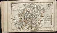
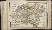
Twenty four new and accurate maps of the several parts of Europe ... : all (except the last) new
Image Count:
1
Alternative Title:
The south part of France, viz. Burgundy, Lyonois, Guienne, Languedoc, Dauphine and Provence
Description:
In pencil on verso: 17.
Subject (Geographic):
Burgundy (France) --Maps --Early works to 1800, Dauphine (France) --Maps, France --Maps --Early works to 1800, Guyenne (France) --Maps, Languedoc (France) --Maps --Early works to 1800, Lyon (France) --Maps, and Provence-Alpes-Cote d'Azur (France) --Maps
Subject (Name):
Barker, B. (Benjamin), d. 1764, bookseller, Clements, Henry, d. 1719, bookseller, King, Charles, d. 1735, bookseller, Nicholson, John, d. ca. 1717, bookseller, Parker, Richard, fl. 1692-1725, bookseller, and Tooke, Benjamin, d. 1716, bookseller
Subject (Topic):
Atlases --Early works to 1800
Collection Created:
[London] : Sold by J. Nicholson at the King’s-Arms in Little Britain, Benj. Barker and Charles King ..., Benj. Tooke ..., Hen. Clements ..., R. Parker and Ralph Smith under the Royal-Exchange ..., [1715?]
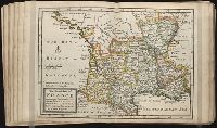
Twenty four new and accurate maps of the several parts of Europe ... : all (except the last) new
Image Count:
1
Alternative Title:
The south-west part of Germany, viz. Mentz and Treeves, Palatine of the Rhine, circles of Franconia, Swabia and Alsace, Lorain the Weteraw, &c
Description:
In pencil on verso: 11.
Subject (Geographic):
Alsace (France) --Maps, Franconia (Germany) --Maps, Germany --Maps --Early works to 1800, Lorraine (France) --Maps, Mainz (Rhineland-Palatinate, Germany) --Maps, Rhineland-Palatinate (Germany) --Maps, Swabia (Germany) --Maps --Early works to 1800, and Trier (Germany) --Maps
Subject (Name):
Barker, B. (Benjamin), d. 1764, bookseller, Clements, Henry, d. 1719, bookseller, King, Charles, d. 1735, bookseller, Nicholson, John, d. ca. 1717, bookseller, Parker, Richard, fl. 1692-1725, bookseller, and Tooke, Benjamin, d. 1716, bookseller
Subject (Topic):
Atlases --Early works to 1800
Collection Created:
[London] : Sold by J. Nicholson at the King’s-Arms in Little Britain, Benj. Barker and Charles King ..., Benj. Tooke ..., Hen. Clements ..., R. Parker and Ralph Smith under the Royal-Exchange ..., [1715?]
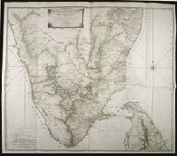
Map with relief shown pictorially, by hachures, and bathymetric soundings., No. 32 of 43 maps bound together in composite atlas., and Scale [ca. 1: 720 000].
Publisher:
Printed for Wm. Faden
Subject (Geographic):
India, South --History, Military --Maps --Early works to 1800