Skip to search
Skip to main content
Skip to first result
Search
You Searched For
Extent of Digitization
Partially digitized
Format
cartographic
New Search
Search Results
Creator:
Call Number:
1976 Folio 110
Collection Title:
The mariners mirrovr wherin may playnly be seen the courses, heights, distances, depths, sounding
Image Count:
1
Resource Type:
Maps, Atlases & Globes
Description:
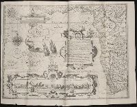
Theodor de Bry, Sculp.
Subject (Geographic):
Bordeaux (France) and Garonne River (Spain and France)
Collection Created:
[London, J. Charlewood? 1588]
Found in:
Beinecke Rare Book and Manuscript Library > The sea coastes of the landes of Poyctou and Bordeaux ...as they shew and appeare, when you sayle there alongst betweene Picquelier and the River of Bordeaux called the Garonne
Call Number:
Lxe 784m
Collection Title:
Geography made easy : being a short, but comprehensive system of that very useful and agreeable
Image Count:
1
Resource Type:
Books, Journals & Pamphlets
Description:
Imperfect: engraving of map not completed.
Subject (Name):
Doolittle, Amos, 1754-1832
Subject (Topic):
Geography
Collection Created:
New Haven : Meigs, Bowen & Dana, [1784]
Found in:
Beinecke Rare Book and Manuscript Library > The situation of [the] kingdoms and states [of Europe]
Creator:
Published / Created:
1775
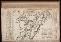
Call Number:
1977 Folio 96
Collection Title:
The West-India atlas: or, A compendious description of the West-Indies: illustrated with forty
Image Count:
1
Resource Type:
Maps, Atlases & Globes
Subject (Geographic):
Turks Island Passage (Turks and Caicos Islands)
Subject (Topic):
Nautical charts
Collection Created:
London, Printed for Robert Sayer and John Bennett, Fleet-Street, 1775
Found in:
Beinecke Rare Book and Manuscript Library > Turks Islands, from a survey made in 1753, by the the sloops l'Aigle and l'Emeraude, by order of the French Governor of Hispaniola, with improvements from observations, made in 1770, in the Sr. Edward Hawke Kings Schooner
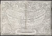
Call Number:
Taylor 136
Collection Title:
La cosmographia, y geographia del S. Hieronimo Girava Tarragones : en la qual se contiene la
Image Count:
1
Description:
Map has several small holes along fold lines. and On verso: map has several small marks ranging from yellow to brown and gray.
Subject (Name):
Miranda, Giovanni de, 16th cent
Subject (Topic):
Discoveries in geography --Early works to 1800, Discoveries in geography --Spanish, Maps --Early works to 1800, and Maps in books --1570
Collection Created:
En Venetia : Por Iordan Zileti, y su companero,
Found in:
Beinecke Rare Book and Manuscript Library > Typo de la carta cosmographica de Gaspar Vopellio Medeburgense
Creator:
Published / Created:
[1596]
Call Number:
Pequot +L65
Collection Title:
Nauigatio ac itinerarium Iohannis Hugonis Linscotani in Orientalem siue Lusitanorum Indiam
Image Count:
1
Description:
[Scale ca. 1:13,000,000]., Bound in following title page of "Descriptio totius Guineae tractus ...", In ink on top left panel of left verso: 3., and Map has several small tears now repaired on verso.
Subject (Geographic):
Africa, West --Maps --Early works to 1800
Subject (Name):
Claesz, Cornelis, ca. 1546-1609, publisher, Elzevier, Gillis, bookseller, and Hendricksz, Aelbrecht, fl. 1573-1605, printer
Subject (Topic):
Voyages and travels --Early works to 1800
Collection Created:
Hagae-Comitis : Ex officina Alberti Henrici, impensis authoris & Cornelii Nicolai, prostantque apud Aegidium Elseuirum, anno 1599
Found in:
Beinecke Rare Book and Manuscript Library > Typus orarum maritimarum Guineae, Manicongo & Angolae ultra promontorium Bonae Spei ...
Creator:
Published / Created:
[1840]
Call Number:
1973 Folio 105
Collection Title:
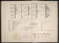
Atlas fisico y politico de la Republica de Venezuela ... por ... Agustin Codazzi ...
Image Count:
1
Resource Type:
Maps, Atlases & Globes
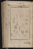
Description:
Caption from index., Double page width, tab mounted., and Lith. de Thierry Fres. Cite Bergere 1 a Paris, printers.
Subject (Geographic):
Venezuela --Statistics
Subject (Topic):
Mountains --Venezuela, Physical geography --Venezuela, and Rivers --Venezuela
Collection Created:
Caracas,
Found in:
Beinecke Rare Book and Manuscript Library > Un cuadro de alturas que comprende las de las cordilleras de Merida, de la costa de Caracas, Coro, Cumana y Margarita, y ultimamente las del sistema de la Parima. Otro cuadro comparativo de la superficie y poblacion de cada provincia. Otro de los principa
Branch:v1.61.8 ,Deployed:2024-06-20T11:14:48-04:00