Includes text and inset of "Key map of Europe.", National political attitudes are represented by caricatures of people, animals, etc., and Yale has two edions of this map: this edition mentions the date of "1899" below the copyright statement.
Publisher:
G.W. Bacon & Co.,
Subject (Geographic):
Europe--Maps, Pictorial and Europe--Politics and government--Maps
Includes text and inset of "Key map of Europe.", National political attitudes are represented by caricatures of people, animals, etc., and Yale has two edions of this map: one edition (30an 1899A) mentions the date of "1899" below the copyright statement.
Publisher:
G.W. Bacon & Co.,
Subject (Geographic):
Europe--Maps, Pictorial and Europe--Politics and government--Maps
Great Britain. Hydrographic Dept Stokes, J. Lort (John Lort), 1811-1885
Published / Created:
Aug. 16th. 1852 [i.e. 1865]
Call Number:
26cea 1851B
Container / Volume:
BRBL_00023
Image Count:
1
Resource Type:
Maps, Atlases & Globes
Description:
"Corrections to ... Mar. 65.", Chart "2142.", and Chart of coast from Barriga Point to Jervis Bay with relief shown by hachures, bathymetric soundings and spot heights.
Publisher:
Published according to Act of Parliament at the Hydrographic Office of The Admiralty : and Sold by J.D. Potter Agent for the Admiralty charts 31 Poultry,
"Additions to ... Mar. 65.", Chart no. "2143.", and Chart of coast from Jervis Bay to Broken Bay with relief shown by hachures, bathymetric soundings and spot heights.
Publisher:
Published according to Act of Parliament at the Hydrographic Office of the Admiralty : and Sold by J.D. Potter for the Admiralty charts 31 Poultry,
"2144"., "Corrections Sept. 1862.", and Chart of coast from Broken Bay to Sugarloaf Point with relief shown by hachures, bathymetric soundings and spot heights.
Publisher:
Published according to Act of Parliament at the Hydrographic Office of The Admiralty : and Sold by J.D. Potter Agent for the Admiralty charts 31 Poultry,
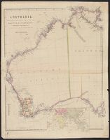
Inset: [Map of Eastern Hemisphere]., Relief shown by hachures. Counties shown with description of topography and some explorations., and Sheet measures 69 x 54 cm.
Publisher:
Pubd. ... by John Arrowsmith, 10 Soho Square,
Subject (Geographic):
Western Australia--Administrative and political divisions--Maps, Western Australia--Discovery and exploration--Maps, and Western Australia--Maps
Evans, F. J. (Frederick J.) Great Britain. Hydrographic Dept J. & C. Walker (Firm) Potter, J. D. (John D.) Washington Capt
Published / Created:
Decr. 12th 1860.
Call Number:
26cea 1860
Container / Volume:
BRBL_00023
Image Count:
1
Resource Type:
Maps, Atlases & Globes
Alternative Title:
Coral Sea and Great Barrier Reefs shewing the inner and outer routes to Torres Strait
Description:
"2764"., Imperfect: Mutilated with loss of tex, Nautical chart of the Great Barrier Reef and the Coral Sea showing routes to the Torres Strait. Relief is shown by hachures and spot heights. Depth shown by bathymetric soundings., and On verso: XXVIII.
Publisher:
Published at the Admiralty ... under the superintendence of Captn. Washington R.N., F.R.S. Hydrographer ; Sold by J.D. Potter, agent for the Admiralty charts, 31 Poultry and 11 King Street, Tower Hill,
Subject (Geographic):
Coral Sea--Maps and Great Barrier Reef (Qld.)--Maps