Skip to search
Skip to main content
Skip to first result
Search
You Searched For
Format
cartographic
Genre
Atlases
Genre
Illustrations
New Search
Search Results
Creator:
Published / Created:
1731
Call Number:
1973 Folio 30
Collection Title:
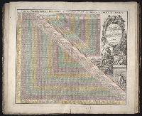
[Atlas factice of 32 maps and 1 distance table, produced by the Homann Erben firm]
Image Count:
2
Alternative Title:
Tabula poliometrica Germaniae ac praecipuorum quorundam locorum Europae
Publisher:
In der Homannische Ufficin
Subject (Geographic):
Europe --Distances, etc --Early works to 1800
Subject (Topic):
Atlases, German --Early works to 1800
Collection Created:
[Nuremberg : s.n., 1701-1760]
Found in:
Beinecke Rare Book and Manuscript Library > Neu vermehrter curioser Meilen-Zeiger der vornehmsten Staedte in Europa, besonders in Teutschland ...
Creator:
Published / Created:
[1732]
Call Number:
E1015 M66 1732
Collection Title:
Atlas minor: or a set of sixty-two new and correct maps, of all parts of the world. All composed
Image Count:
1
Description:
Autograph of Gravely. Autograph of Baldock. Autograph of Aston. Autograph of W. Alington. and Teaching resource: Professor John Mack Faragher, History 141: The American West.
Subject (Geographic):
America--Maps--Early works to 1800
Subject (Topic):
Atlases--Early works to 1800
Collection Created:
London :
Found in:
Beinecke Rare Book and Manuscript Library > The Island of St. Christophers, alias St. Kitts By H. Moll Geographer
Branch:v1.61.8 ,Deployed:2024-06-20T11:15:15-04:00