"Avec privil.", Backed with paper. Ms. no. "97" in upper right-hand corner. Sheet measures 53.6 x 63.5 cm. No. 87 of 87 maps bound together., Includes four bar scales., Includes inset: Carte particulière du Détroit de Magellan., Relief shown pictorially., and Untitled inset shows Southern Hemisphere.
Publisher:
Elizabeth Visscher,
Subject (Geographic):
Magellan, Strait of (Chile and Argentina)--Maps--Early works to 1800., South America--Maps--Early works to 1800., and Southern Hemisphere--Maps--Early works to 1800.
Anville, Jean Baptiste Bourguignon d', 1697-1782, cartographer.
Published / Created:
1719
Call Number:
3945 1719
Container / Volume:
BRBL_00193
Image Count:
2
Resource Type:
Maps, Atlases & Globes
Alternative Title:
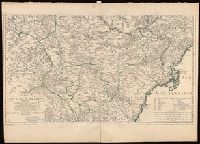
Theatre de la guerre d'Espagne
Description:
Imperfect: Left margin trimmed, with some loss of text. Sheets measure 55 x 76 cm. Versos: Nos. 151-152 in ink., Relief shown by hachures., and Watermarks.
Coordinates not present on map and are approximated., Includes dedication to "Monsieur le Marquis Brignole Sale"., North oriented towards the left., Relief shown by hachures and pictorially., and Watermark.
Publisher:
chez le Sr. Jaillot Geographe Ordinaire du Roy, Quay et attenant les Grands Augustins, aux Deux Globes,
Imperfect: Sheets 1-2 only; mutilated with loss of information., Includes Adriatic and Azof Seas., and Relief shown by hachures. Depths shown in soundings.
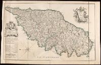
From: Atlas national illustre / V. Levasseur., In bottom left margin: Impie. Lemercier, rue de Seine 57 - Paris., In bottom right margin: La geographie gravee par A. Piat., In top right margin: Emisphere Austral no. 88., Insets: Parny -- Bertin., and Map of Reunion showing major rivers. Relief shown by hachures and spot heights.
Publisher:
Chez l'Editeur Rue de la Parcheminerie, 15,
Subject (Geographic):
Réunion--Maps.
Subject (Name):
Lemercier, active 1838-1875., Levasseur, V. (Victor). Atlas national illustre., and Piat, A.
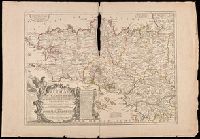
Hand colored. Stamp: Karpinski-von Wieser Map Collection. and Includes notes, explanation of scales and an "Avertissement".
Publisher:
Chez J.B. Nolin, sur le Quay de l'Horloge du Palais a l'Enseigne de la Place des Victoires, Vers le Pont Neuf, Avec Privilege du Roy,
Subject (Geographic):
Brittany (France)--Administrative and political divisions--Maps--Early works to 1800., Brittany (France)--Maps--Early works to 1800., and France--Brittany
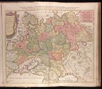
Russiae, Albae, sive Moscoviae delineatio geographica accurata et nova
Description:
Appeared in Peter Schenk's Atlas contractus [ca. 1700]., BEIN 1973 Folio 18: Backed with paper. Ms. no. "4" in upper right-hand corner. Sheet measures 53.4 x 62.0 cm. No. 3 of 87 maps bound together., Includes six bar scales., Prime meridian: Ferro., and Relief shown pictorially.
Publisher:
Studio et labore Petr. Schenck,
Subject (Geographic):
Europe, Eastern--Maps--Early works to 1800. and Russia--Maps--Early works to 1800.
Subject (Name):
Schenk, Peter, 1660-1718 or 1719. Atlas contractus.