Partie de l'Amérique septent[rionale] qui comprend la Nouvelle France ou le Canada
Description:
"Avec privilege 1755.", "C. Haussard sculp.", "Wm. Inglis Morse Collection" -- on recto in upper right corner. Stamp on verso: Canada. No. on verso: 103., From the author's Atlas universel. 1757[-1758]., Inset of "Supplement pour les lacs du Canada." Scale [ca. 1:5,500,000]., Relief shown pictorially., Second state, with "I. Charlton" in James Bay named and the location and orientation of "F. de la Presqu'íle" changed., and Watermark.
Publisher:
s.n.,
Subject (Geographic):
Canada--Maps--Early works to 1800., Great Lakes Region (North America)--Maps--Early works to 1800., and New France--Maps--Early works to 1800.
Subject (Name):
George Washington's American Atlas., Haussard, Catherine, engraver., Morse, William Inglis,--b. 1874--Stamp., Robert de Vaugondy, Gilles, 1688-1766. Atlas universel., and Washington, George,--1732-1799--Ownership.
Covers the area from Lake Superior to Kaskaskia and from Delaware Bay to the Mississippi River., Relief shown pictorially., Shows a few towns, missions, forts, Indian villages and tribal territory, rivers and lakes, portages, and early place-names., and Watermark.
Publisher:
[Homann Erben?],
Subject (Geographic):
Canada--Maps--Early works to 1800., Great Lakes Region (North America)--Maps--Early works to 1800., and New France--Maps--Early works to 1800.
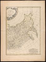
Imperfect: western sheet wanting. With watermark., Left sheet, top right: XIX., Left sheet: bottom right: 22. Right sheet: bottom right A22., Prime meridian: Ferro., Relief shown pictorially., Right sheet, top right: XX., and Source of map: Atlas moderne ou collection de cartes sur toutes les parties du globe terrestre.
Publisher:
chez Lattré ruë St. Jacques à la ville de Bordeaux, avec pr. du roy,
Subject (Geographic):
Asiatic Russia--Maps--Early works to 1800. and Russia--Maps--Early works to 1800.
Subject (Name):
Arrivet, J., engraver. and Lattré, Jean, engraver.
Letters from missions. Lettres édifiantes et curieuses, écrites des missions étrangères.
Image Count:
1
Resource Type:
Maps, Atlases & Globes
Description:
Coordinates are approximated., Imperfect: torn along fold, with some loss of text., Relief shown pictorially., Shows northern Sea of Cortes and adjacent lands, with California connected to mainland., and The map appeared in 1705 in volume 5 of the series "Lettres édifiantes et curieuses, écrites des missions étrangères."
Publisher:
[F. Kino],
Subject (Geographic):
Baja California (Mexico : Peninsula)--Maps--Early works to 1800. and California, Gulf of (Mexico)--Maps--Early works to 1800.
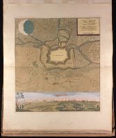
Ordre de Battaille von denen Trouppen so die Insul Rugen eingenommen haben
Description:
"Avec privilege"., Backed with paper. Illegible inscription. Ms. no. "12" in upper right corner. Sheet measures 53.5 x 62.5 cm. No. 11 of 87 maps bound together., Relief shown by hachures., and Watermark.
Publisher:
Chez Anna Beek á la Haie,
Subject (Geographic):
Rügen Island (Germany)--Maps--Early works to 1800.
Backed with paper. Ms. no. "81" in lower right corner. Sheet measures 62.2 x 53.7 cm. No. 75 of 87 maps bound together. and Includes bird's-eye view of Temeswar at bottom.
"Avec privilege.", Appeared in Anville's Atlas général., Imperfect: Mutilated wih loss of text. Hand colored. Sheets joined. Manuscript note in unidentified hand., Includes seven bar scales., and Relief shown pictorially.
Publisher:
Chez l'Auteur aux Galerie du Louvre,
Subject (Geographic):
Asia--Maps--Early works to 1800.
Subject (Name):
Anville, Jean Baptiste Bourguignon d', 1697-1782. Atlas général. and Haye, G. de la
Imperfect: torn along left fold, with no loss of text. Backed with paper. Ms. no. "11" in upper right-hand corner. Sheet measures 53.5 x 61.6 cm. No. 10 of 87 maps bound together. and Relief shown pictorially.
Publisher:
Chez Pierre Husson,
Subject (Geographic):
Stralsund (Germany)--Maps.
Subject (Topic):
Northern War, 1700-1721--Campaigns--Germany--Mecklenburg (Region) and Northern War, 1700-1721--Maps--Early works to 1800.
Carte generale de la Tartarie chinoise et des royaumes de Corée et de Iapan
Description:
French alternate title only., Imperfect: western sheet (with cartouche) wanting. Sheet measures 54 x 54 cm, with watermark., Includes text and ill., and Relief shown pictorially.
Publisher:
Curis Homannianorum Heredum,
Subject (Geographic):
Chine--Divisions politiques et administratives--Cartes--Ouvrages avant 1800. and Manchuria (China)--Maps--Early works to 1800.
Subject (Name):
Anville, Jean Baptiste Bourguignon d', 1697-1782., Du Halde, J.-B. (Jean-Baptiste), 1674-1743., Gerbillon, Jean-François, 1654-1707., Homann Erben (Firm), and Mayer, Tobias, 1723-1762.
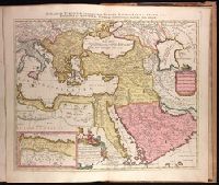
Imperium Turcicum, complectens Europae, Asiae et Africae, Arabiae que regiones ac provincias plurimas, industria et labore Petr. Schenck
Description:
Appeared in Peter Schenk's Atlas contractus., Backed with paper. Ms. no. "91" in upper right-hand corner. Sheet measures 53.6 x 62.5 cm. No. 83 of 87 maps bound together., Includes six bar scales., Inset map [partially obscuring title in cartouche] is continuation of the North African coastline., Prime meridian: Ferro., and Relief shown pictorially.
Publisher:
P. Schenck, avec privil,
Subject (Geographic):
Africa, North--Maps--Early works to 1800., Europe, Southern--Maps--Early works to 1800., Middle East--Maps--Early works to 1800., and Turkey--Maps--Early works to 1800.
Subject (Name):
Schenk, Peter, 1660-1718 or 1719. Atlas contractus.