Dimidia Tribvs Manasse ultra Jordanem, tribus Neptalim et partes orientales Tribuum Zabvion et Isachar
Description:
Appears in Jansson's historical atlas editions from 1652-1684 and in his Accuratissima orbis antiqui delineatio. From 1653 on, this work is known under the name of Hornius, who wrote the text and compiled all the maps for the atlases--(Koeman-Krogt. 1:601-1:607)., Coordinates not present on map and are approximated., Inset: Peregrinatio Abrahae., Map indexed with grid lines and alphabet letters P-R at top., Oriented with north toward the left., Printed on one and a half sheets., Relief shown pictorially., and Watermark. Manuscript numbers in upper left and right corners: 46. No. 4 of 6 maps housed together.
Publisher:
[Jan Jansson],
Subject (Geographic):
Palestine--History--To 70 A.D.--Maps--Early works to 1800. and Palestine--Maps--Early works to 1800.
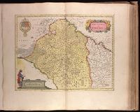
Bar scale given in "miglia sette.", Relief shown pictorially., and Sheet printed from cracked plate. Backed with paper. Ms. no. "72" in upper right corner. Sheet measures 53.7 x 62.6 cm. No. 67 of 87 maps bound together.
Publisher:
Joan Blaeu,
Subject (Geographic):
Parma (Italy : Province)--Maps--Early works to 1800. and Piacenza (Italy : Province)--Maps--Early works to 1800.
Backed with paper. Ms. no. "73" in upper right corner. Sheet measures 53.6 x 63.0 cm. No. 68 of 87 maps bound together., Bar scale given in "miglia sette d'Italia.", and Relief shown pictorially.
Publisher:
Joan Blaeu,
Subject (Geographic):
Milan (Italy : Province)--Maps--Early works to 1800.
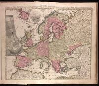
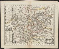
"Cum privilegio Amsteld. et Regis Poloniae .", Backed with paper. Ms. no. "3" in upper right-hand corner. Sheet measures 53.4 x 62.0 cm. No. 2 of 87 maps bound together., Includes two insets showing the path of the solar eclipse of May 12, 1706., Prime meridian: Ferro., and Relief shown pictorially.
Publisher:
Á Petro Schenk,
Subject (Geographic):
Europe--Maps--Early works to 1800.
Subject (Name):
Moolen, Simon van de. and Schenk, Peter, 1660-1718 or 1719.
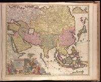
Backed with paper. Ms. no. "88" in upper right corner. Sheet measures 53.4 x 62.5 cm. No. 81 of 87 maps bound together., Inset: Tartariae pars. Scale not given., Map [51] from: Magnum theatrum belli, quousque se hodie in orbe extendit : continens novissimas et perfectissimas, tam particulares quam generales, Tabulas Geographicas : Germaniae, Beglii, Hungariae, Italiee, Galliae, Hispaniae, Magniae Britaniae, Scandinaviae, Poloniae, Moscoviae, Asiae, Americae et Africae : cum speciali indice, quo cujuslibet Tabulae notabilia exhibentur / opus collectum a Carolo Allard. Amstelo Batavo : [C. Allard?, 1702]., Prime meridian: Ferro., Relief shown pictorially., and The map covers most of Eurasia from the Middle East, the whole of Tartaria [i.e. China and the Russian Republic in the north], Iaponia [i.e. Japan] and an incomplete outline of Yedso [probably the islands of Hokkaido and Sakhalin] and all of South East Asia, including the East Indies. It incorporates Nicholas Witsen's Asian and Siberian cartography - Witsen was a prominent politician, Mayor of Amsterdam, scholar and cartographer. The decorative cartouche features an oriental courtesan with merchants of many nations presenting gifts. Relief is shown pictorially.
Publisher:
[Carel Allard,
Subject (Geographic):
Asia--Maps--Early works to 1800.
Subject (Name):
Allard, Carel, 1648-ca. 1709. Magnum theatrum belli., Gouwen, Gilliam van der, engraver., Tidemann, Philipp, 1657-1705., and Witsen, Nicolaas, 1641-1717.
Carte de la Louisiane ou des voyages du Sr. De La Salle
Description:
"Reduced facsimile of MS. copy (made in Paris for Francis Parkman), now in the Library of Harvard University. The original, formerly in the Archives de la Marine, Paris, has been lost.", Facsimile., From the Jesuit Relations, vol. 63, frontispiece., and Relief shown pictorially.
Publisher:
s.n.,
Subject (Geographic):
New France--Maps--Early works to 1800--Facsimiles. and North America--Maps--Early works to 1800--Facsimiles.
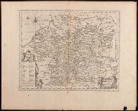
Backed with paper. Ms. no. "54" in upper-right corner. Sheet measures 53.7 x 63.1 cm. No. 49 of 87 maps bound together., Bar scale given in "milliaria Gallica"., Decorative title cartouche in upper right, coat of arms in upper left, and bar scale cartouche with one figure at the left side, with books and sun, in lower left corner., Prime meridian: Ferro., Relief shown pictorially., Verso blank., Watermark below title cartouche., and Watermark.
Publisher:
Excud. Guiljelmus Blaeu,
Subject (Geographic):
Burgundy (France)--Maps--Early works to 1800., Centre (France)--Maps--Early works to 1800., and Île-de-France (France)--Maps--Early works to 1800.
Keere, Pieter van den, 1571-approximately 1646, cartographer.
Published / Created:
[between 1652 and 1684]
Call Number:
BrSides Double Folio 2019 103
Image Count:
1
Resource Type:
Maps, Atlases & Globes
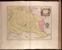
Description:
Appears in Jansson's historical atlas editions from 1652-1684., Manuscript number in upper left corner: 13., and Relief shown pictorially.
Publisher:
Apud Joannem Janssonium,
Subject (Geographic):
Benelux countries--Historical geography--Maps--Early works to 1800., Benelux countries--Maps--Early works to 1800., Europe, Central--Historical geography--Maps--Early works to 1800., and Europe, Central--Maps--Early works to 1
Subject (Name):
Jansson, Jan, 1588-1664, publisher.
Subject (Topic):
Ethnology--Europe--Maps--Early works to 1800. and Germanic peoples--Maps--Early works to 1800.
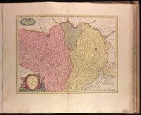
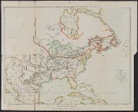
Appears in Jansson's historical atlas editions from 1652-1684., Hand colored., and Relief shown pictorially.
Publisher:
Apud Joannem Janssonium,
Subject (Geographic):
Benelux countries--Historical geography--Maps--Early works to 1800., Benelux countries--Maps--Early works to 1800., Europe, Central--Historical geography--Maps--Early works to 1800., Europe, Central--Maps--Early works to 1800., Europe, Eastern--Historical geography--Maps--Early works to 1800., Europe, Eastern--Maps--Early works to 1800., Germany--Historical geography--Maps--Early works to 1800., and Germany--Maps--Early works to 1800.
Subject (Name):
Jansson, Jan, 1588-1664
Subject (Topic):
Ethnology--Europe--Maps--Early works to 1800. and Germanic peoples--Maps--Early works to 1800.