Annales des voyages, de la géographie et de l'histoire.
Description:
"Ve. Souscription. Tome II, Cahier III, pag. 395" above neat line., From "Annales des voyages, de la géographie et de l'histoire.", Includes five bar scales., Prime meridian: Paris., Relief shown by hachures., and Watermark.
Publisher:
[François Buisson],
Subject (Geographic):
Denmark--Maps
Subject (Name):
Buisson, François, 1753-1814, Pelicier, A. (Alphonse), and Tardieu, Antoine-François
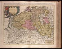
Provinces des Pays Bas catholiques, restées pour la pluspart sous l'obeissance du roy d'Espagne
Description:
Appeared in Peter Schenk's Atlas contractus [ca. 1700]., Backed with paper. Ms. no. "39" in upper-right corner. Sheet measures 53.5 x 62.4 cm. No. 38 of 87 maps bound together., Bar scales given in "lieues communes d'Allemagne," "lieues communes de France," and "mile de Italie"., Prime meridian: Ferro., and Relief shown pictorially.
Publisher:
Chez P. Schenk,
Subject (Geographic):
Benelux countries--Maps--Early works to 1800. and France, Northern--Maps--Early works to 1800.
Subject (Name):
Schenk, Peter, 1660-1718 or 1719. Atlas contractus.
Appears in Justus Danckerts's first two Atlas editions; see Koeman, C. Atlantes Neerlandici, vol. III, Dan 1, Dan 2., Backed with paper. Ms. no. "59" in upper right-hand corner. Sheet measures 53.8 x 62.8 cm. No. 54 of 87 maps bound together., Bar scales given in "milliaria Germanica communia" and "milliaria Gallica communia"., Prime meridian: Ferro., and Relief shown pictorially.
Publisher:
Theodore Danckerts,
Subject (Geographic):
Alsace (France)--Maps--Early works to 1800., Baden-Württemberg (Germany)--Maps--Early works to 1800., Lorraine (France)--Maps--Early works to 1800., and Saarland (Germany)--Maps--Early works to 1800.
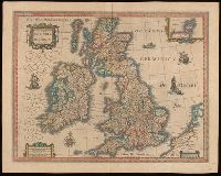
Bar scales given in "milliaria Anglica communia," "milliaria Anglica parva," and "milliaria Germanica communia.", From Joan Blaeu's Latin edition of Theatrum orbis terrarum (1648)., In Latin on verso, with caption title "Britannia," signature A, and paginated 1-2., Relief shown pictorially., Watermark., and With inset map "Orcades insulae."
Subject (Geographic):
Great Britain--Maps--Early works to 1800.
Subject (Name):
Blaeu, Joan, 1596-1673 and Blaeu, Joan, 1596-1673. Theatrum orbis terrarum.
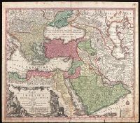
Includes three bar scales., Prime meridian: Ferro., Relief shown pictorially., and Watermark. Manuscript number in upper right corner: 94. From the Karpinski Collection.
Publisher:
[Mattheus Seutter],
Subject (Geographic):
Middle East--Maps--Early works to 1800.
Subject (Name):
Drentwet, Abraham, -1785, engraver. and Karpinski, Louis Charles,--1878-1956--Ownership.
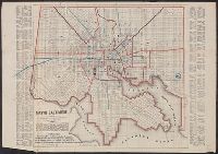
Above neat line at bottom left: Wm. Sides surveyor Balto., Identifies street names, major buildings, wards, and street railways., Lithographed by: A. Hoen & Co. Second St. Balto., Printed label of J.F. Weishampel pasted over title. Printed labels, and Street inde
Map of Cook's tours in Ireland. and Map of Cook's tours in Scotland & England.
Description:
Coordinates not present on map and are approximated., Imperfect: brittle and chipped, with some loss of text., Inset: Portion of Norway and Sweden., On verso: Map of Cook's tours in Ireland; Map of Cook's tours in Scotland & England., and Shows railroads, "Railways over which Cook's tickets are available," and steamship routes.
Map of Texas :, Map of Texas ; Seat of war, and Seat of war
Description:
Hand-colored boundary line., Imperfect: Mutilated with loss of information., Inset map has title: Seat of war., Relief shown by hachures., and Text in box below title begins: The present boundaries of Texas are defined by an act of the Texian Congress ...
Also shows roads and tourist information., Covers the area southward from Mediterranean Sea to Lake Chad region and eastward from Algeria to Libya/Egypt border., and Maps on verso: Tunis -- Alger -- Tunisia Orient -- Tripoli [area] -- Tripoli -- Oran -- Africa, index map.
Publisher:
Corps of Engineers,
Subject (Geographic):
Africa, North--Maps, Tourist., Africa, North--Maps., Africa, North--Road maps., Chad, Lake, Region--Maps, Tourist., Chad, Lake, Region--Maps., and Chad, Lake, Region--Road maps.