Map of the Northern Pacific Railroad, showing the intercontinental routes, oceanic currents and steamboat lines around the world. and Profiles of the Northern Pacific and the Central and Union Pacific Railroads, showing the difference in configuration of the country along the respective routes.
Description:
Imperfect: chipped along folds, with some loss of text. Backed with paper., Includes inset of "Map of the Northern Pacific Railroad, showing the intercontinental routes, oceanic currents and steamboat lines around the world," text, and "Profiles of the Northern Pacific and the Central and Union Pacific Railroads, showing the difference in configuration of the country along the respective routes.", Prime meridians: Greenwich and Washington., and Relief shown by hachures and spot heights.
Subject (Geographic):
North America--Maps.
Subject (Name):
Northern Pacific Railroad Company--Maps.
Subject (Topic):
Railroads--Canada--Maps. and Railroads--United States--Maps.
Atwood, John M., approximately 1818- cartographer.
Published / Created:
1849
Call Number:
71 1849
Image Count:
1
Resource Type:
Maps, Atlases & Globes
Description:
Includes 2 insets, ill., and distance table., Prime meridians: Greenwich and Washington., Relief shown by hachures and spot heights., Shows California's gold region and western trails., and Variant ed. in same year.
Publisher:
J.H. Colton,
Subject (Geographic):
California--Gold discoveries--Maps., North America--Maps., and United States--Maps.
Subject (Name):
Colton, J. H. (Joseph Hutchins), 1800-1893, publisher.
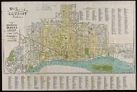
"Compliments of the Burton Abstract and Title Co.", Coordinates not present on map and are approximated., Illegible manuscript note., and Includes street index.
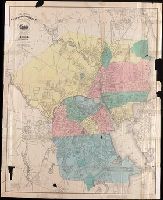
Coordinates not present on map and are approximated., Imperfect: Mutilated with loss of text., Imperfect: torn along some folds, with no loss of text., Includes index to churches, public buildings and railway stations,, Map divided into zones A-Z., and Shows streets and railways in Mexico City.
Publisher:
[publisher not identified],
Subject (Geographic):
Mexico City (Mexico)--Maps.
Subject (Name):
Janvier, Thomas A. (Thomas Allibone), 1849-1913. Mexican guide.
Subject (Topic):
Railroads--Mexico--Mexico City--Maps. and Streets--Mexico--Mexico City--Maps.
"Plate XXXVI" in upper right corner., Bar scale given in "British statute miles.", Coordinates not present on map and are approximated., and North oriented towards bottom of map.
Publisher:
Published Jany 1st, 1803, by Cadell & Davies, Strand,
Coordinates not present on map and are approximated., Imperfect: torn along some folds, with no loss of text., Relief shown by hachures and pictorially., and Shows railway lines.
Publisher:
[Charles Scribner's Sons?],
Subject (Geographic):
Mexico City Region (Mexico)--Maps.
Subject (Name):
Janvier, Thomas A. (Thomas Allibone), 1849-1913. Mexican guide. and Pacheco, Carlos, 1839-1891.
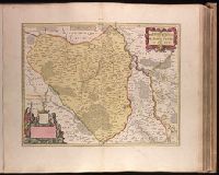
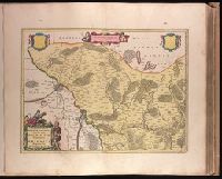
Marchionatus Brandenburgici pars, quae marchia media vulgo Mittelmarck audit
Description:
Bar scale given in "milliaria Germanica"., BEIN 1973 Folio 18: Backed with paper. Ms. no. in upper right corner: 19. Sheet measures 53.7 x 63.4 cm. No. 19 of 87 maps bound together., Prime meridian: Ferro., Relief shown pictorially., Watermark., and With blank shield in upper right.
Publisher:
Excud. Joannes Blaeu,
Subject (Geographic):
Brandenburg (Germany : Landkreis)--Maps--Early works to 1800.
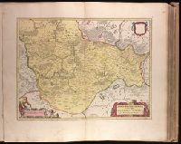
Backed with paper. Ms. no. in upper right corner: 21. Sheet measures 53.7 x 62.5 cm. No. 21 of 87 maps bound together., Bar scale given in "milliaria Germanica"., Dedication cartouche with blank text panel and blank shield., and Prime meridian: Ferro.
Publisher:
Joan Blaeu,
Subject (Geographic):
Saxony-Anhalt (Germany)--Maps--Early works to 1800.
Backed with paper. Ms. no. in upper right corner: 18. Sheet measures 53.6 x 62.9 cm. No. 18 of 87 maps bound together., Bar scale given in "milliaria Germanica"., Prime meridian: Ferro., and With two blank shields.
Publisher:
Joan Blaeu,
Subject (Geographic):
Brandenburg (Germany : Landkreis)--Maps--Early works to 1800.