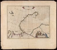
Bookplate: From the collection of Laura K. and Valerian Lada-Mocarski., From Joan Blaeu's Grooten atlas, Dutch edition, 1664., In Dutch on verso, paginated 5a, with signature D, and caption titles "Nova Zembla.", Verso includes hand colored engraving (17 x 22 cm) by Hessel Gerritsz with letterpress title: Afbeelding van een Walrus, met een sijner jongen., and Watermark.
Publisher:
[Joan Blaeu],
Subject (Geographic):
Novai͡a Zemli͡a (Russia)--Maps--Early works to 1800.
Subject (Name):
Blaeu, Joan, 1596-1673. Grooten atlas., Gerritsz., Hessel, approximately 1581-1632., Lada-Mocarski, Laura K.--(Laura Klots),--1902-1997--Bookplate., and Lada-Mocarski, Valerian,--1898-1971--Bookplate.
"Amstelodami cum privilegio D.D. ordin. Hollandiae Westfrisiaeq[ue].", Backed with paper., Illustrated hand colored title cartouche; sea decorated with ships., Prime meridian: Ferro., and Relief shown pictorially.
Bar scales given in "Milliaria Germanica" and "Milliaria Gallica.", Relief shown pictorially., and Watermark. Manuscript number in upper right corner: 49.
Publisher:
[Matthaeus Seutter],
Subject (Geographic):
Azov, Sea of, Region (Ukraine and Russia)--Maps--Early works to 1800.
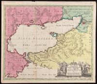
"Cum Privil.", Appeared in Peter Schenk's Atlas contractus., Backed with paper. Ms. no. "47" in lower-right corner. Sheet measures 62.5 x 53.7 cm. No. 44 of 87 maps bound together., Includes four bar scales., Prime meridian: Ferro., and Relief shown pictorially.
Publisher:
Peter Schenk],
Subject (Geographic):
Scotland--Maps--Early works to 1800.
Subject (Name):
Schenk, Peter, 1660-1718 or 1719. Atlas contractus.
"Cum privilegio.", Backed with paper. Ms. no. "49" in lower-right corner. Sheet measures 63.1 x 53.8 cm. No. 46 of 87 maps bound together., Includes four bar scales., Prime meridian: Ferro., Relief shown pictorially., and Watermark.
Publisher:
[Peter Schenk,
Subject (Geographic):
Ireland--Maps--Early works to 1800.
Subject (Name):
Schenk, Peter, 1660-1718 or 1719. Atlas contractus.
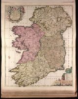
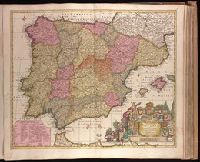
"Cum privil. Regis Polon. et Elect. Sax. et Hollandiae et Westfrisiae.", Backed with paper. Ms. no. "63" in upper right-hand corner. Sheet measures 53.5 x 62.3 cm. No. 58 of 87 maps bound together., Bar scales given in "milliaria Germanica," "milliaria Hispanica," and "mill. Gallica.", Prime meridian: Ferro., Relief shown pictorially., and Watermark.
Publisher:
[Peter Schenk],
Subject (Geographic):
Portugal--Maps--Early works to 1800. and Spain--Maps--Early works to 1800.
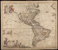
"Cum Privilegio D.D. Ordinum Holl. Westfriliegs.", According to P.D. Burden, Mapping of North America, this is the seventh state of de Wit's map of America, with a new title engraved adding the privilege statement, lower case letters inserted between the latitude numbers and upper case letters between the longitude, and the longitudinal line 338° bearing a bad plate crack in the souther hemipshere, with an erased compass rose at the junction of 338° longitude and 10° north latitude., Appears in various editions of Wit's Atlas., Baked with paper., Number "2" in upper right corner., Prime meridian: Ferro., Relief shown pictorially., and Watermark.
Subject (Geographic):
America--Maps--Early works to 1800. and Western Hemisphere--Maps--Early works to 1800.
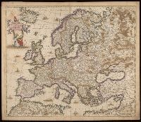
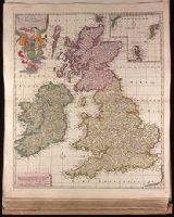
"Cum privilegio Reg. Pott. et Elect. Saxoniae et Ord. Hol. et Westfrisiae"., Backed with paper. Ms. no. "46" in lower right-hand corner. Sheet measures 63.1 x 53.7 cm. No. 43 of 87 maps bound together., Includes four bar scales., Prime meridian: Ferro., Relief shown pictorially., Watermark., and With inset map of Shetland and Faroe Islands.
"R. de Hooghe f.", Appeared in Valk and Schenk's Atlantis sylloge compendiosa, ca. 1702., Backed with paper. Ms. no. "62" in lower right-hand corner. Sheet measures 53.6 x 62.8 cm. No. 57 of 87 maps bound together., Bar scales given in "milliaria Germanica" and "milliaria Gallica.", Prime meridian: Ferro., Relief shown pictorially., and Watermark.
Publisher:
By Gerard Valk op den Dam in de Wackere Hont, t'Amsterdam met privilegie van de Ed. Gr. Moog. Heeren staaten van Holl. en West Vriesland,
Subject (Geographic):
Aquitaine (France)--Maps--Early works to 1800.
Subject (Name):
Hooghe, Romeyn de, 1645-1708, engraver., Schenk, Peter, 1660-1718 or 1719. Atlantis sylloge compendiosa., Valck, G. (Gerard), 1651 or 1652-1726. Atlantis sylloge compendiosa., and Valck, Leonard, 1675-1746.
"Meyers Konv.-Lexicon, 6. Aufl.", "Zum Artikel 'Guinea'.", Inset: Mittel-Deutschland in gleichem Masstab., and Relief shown by hachures and spot heights.