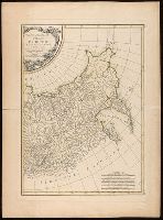
From Hugo Strumm's Der Russische feldzug nach Chiwa (1875)., In upper left corner, "Zu Lt. Stumm's Russ. Feldzug nach Chiwa.", In upper right corner, "Taf. III (zum Schlufs des II. Theils.)", and Relief shown by hachures.
Publisher:
[Mittler],
Subject (Geographic):
Asia, Central--Maps.
Subject (Name):
Kraatz, Leopold, lithographer. and Stumm, Hugo. Russische feldzug nach Chiwa.
Appeared in Anville's Atlas général., Hand colored in outline., Imperfect: In 2 pieces., Includes eight bar scales., Prime meridian: Ferro., Relief shown pictorially., Shows rivers and settlements; note., and Watermark.
Publisher:
[Jean Baptiste Bourguignon d'Anville],
Subject (Geographic):
Greece--Maps--Early works to 1800., Middle East--Maps--Early works to 1800., Rome--Maps--Early works to 1800., and Turkey--Maps--Early works to 1800.
Subject (Name):
Anville, Jean Baptiste Bourguignon d', 1697-1782. Atlas général. and Haye, G. de la, engraver.
Subject (Topic):
Bible--Geography--Maps--Early works to 1800. and Classical geography--Early works to 1800--Maps.
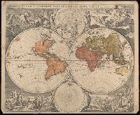
"J. de Vissscher sculpsit"., Decorations by N.P. Berchem., First appeared in Jan Jansson's 1658 ''Novus Atlas''., Imperfect: southern hemisphere mutilated along fold, with some loss of text. Contemporary ms. notes in margin. Rebacked on linen. Label on verso with manuscript number "588/60." Cross collection no. 19., Shows California as an island., and Two hemispheres surrounded by mythological figures, with polus articus at top center and polus antarcticus at bottom center.
Publisher:
[Jan Jansson],
Subject (Name):
Berchem, Nicolaas Pietersz, 1620-1683., Jansson, Jan, 1588-1664. Novus Atlas., and Visscher, Jan de, 1633-approximately 1692.
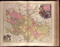
"Cum Privil. Ordin. Gen. Belg. Foed.", Appeared in Peter Schenk's Atlas contractus [ca. 1700]., Backed with paper. Ms. no. "33" in upper-right corner. Sheet measures 53.5 x 62.7 cm. No. 32 of 87 maps bound together., Bar scales given in "milliaria Germanica" and "milliaria Gallica"., Dedication: Sereniss. ac Potentissimo Dn. Dn. Iohanni Guilielmo Dg. Com. Palat. Rhen. S. R. I. Archithesaur. et Elect. Bavar. Iul. Cliv. ac Mont. Duc. etc. etc. Princ. ac Domino suo clementissimo hanc Palatinatus Rhen. Tabulam submisse dicat et consecrat., Prime meridian: Ferro., Relief shown pictorially., and Watermark.
Publisher:
Peter Schenk,
Subject (Geographic):
Baden-Württemberg (Germany)--Maps--Early works to 1800., Hesse (Germany)--Maps--Early works to 1800., and Rhineland-Palatinate (Germany)--Maps--Early works to 1800.
Subject (Name):
Schenk, Peter, 1660-1718 or 1719. Atlas contractus.
"Levée par les Officiers du Corps dÉtat-Major, et publiér par le Dépòt de la Guerre en 1832.", "Révisée en 1901.", "Type 1889.", Includes number 48 in upper right corner., Relief shown by hachures., and Shows city with Paris-centric coordinates.
Appears in Jansson's historical atlas editions from 1652-1684 and in his Accuratissima orbis antiqui delineatio. From 1653 on, this work is known under the name of Hornius, who wrote the text and compiled all the maps for the atlases--(Koeman-Krogt. 1:601-1:607)., Coordinates not present on map and are approximated., Inset: Itinera et mansiones deserti., Map indexed with grid lines and alphabet letters A-H at top., Oriented with north toward the left., Relief shown pictorially., Shows greater part of the Tribe of Judah, with Biblical illustrations., and Watermark. Manuscript number in upper left corner: 48. No. 5 of 6 maps housed together.
Publisher:
[Jan Jansson],
Subject (Geographic):
Palestine--History--To 70 A.D.--Maps--Early works to 1800. and Palestine--Maps--Early works to 1800.
Robert de Vaugondy, Gilles, 1688-1766, cartographer.
Call Number:
73 1785
Image Count:
1
Resource Type:
Maps, Atlases & Globes
Alternative Title:
Partie de l'Amérique septent[rionale] qui comprend la Nouvelle France ou le Canada
Description:
Decorative title cartouche by Graux., Fourth state with date in cartouce removed., From the author's Atlas universel., Inset of "Supplement pour les lacs du Canada" (scale approximately 1:5,500,000)., Relief shown pictorially., and Watermark.
Subject (Geographic):
Canada--Maps--Early works to 1800., Great Lakes Region (North America)--Maps--Early works to 1800., and New France--Maps--Early works to 1800.
Subject (Name):
Robert de Vaugondy, Gilles, 1688-1766. Atlas universel.
Partie de l'Amérique septent[rionale] qui comprend la Nouvelle France ou le Canada
Description:
"Avec privilege 1755.", "C. Haussard sculp.", "Wm. Inglis Morse Collection" -- on recto in upper right corner. Stamp on verso: Canada. No. on verso: 103., From the author's Atlas universel. 1757[-1758]., Inset of "Supplement pour les lacs du Canada." Scale [ca. 1:5,500,000]., Relief shown pictorially., Second state, with "I. Charlton" in James Bay named and the location and orientation of "F. de la Presqu'íle" changed., and Watermark.
Publisher:
s.n.,
Subject (Geographic):
Canada--Maps--Early works to 1800., Great Lakes Region (North America)--Maps--Early works to 1800., and New France--Maps--Early works to 1800.
Subject (Name):
George Washington's American Atlas., Haussard, Catherine, engraver., Morse, William Inglis,--b. 1874--Stamp., Robert de Vaugondy, Gilles, 1688-1766. Atlas universel., and Washington, George,--1732-1799--Ownership.
Covers the area from Lake Superior to Kaskaskia and from Delaware Bay to the Mississippi River., Relief shown pictorially., Shows a few towns, missions, forts, Indian villages and tribal territory, rivers and lakes, portages, and early place-names., and Watermark.
Publisher:
[Homann Erben?],
Subject (Geographic):
Canada--Maps--Early works to 1800., Great Lakes Region (North America)--Maps--Early works to 1800., and New France--Maps--Early works to 1800.
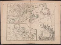
Imperfect: western sheet wanting. With watermark., Left sheet, top right: XIX., Left sheet: bottom right: 22. Right sheet: bottom right A22., Prime meridian: Ferro., Relief shown pictorially., Right sheet, top right: XX., and Source of map: Atlas moderne ou collection de cartes sur toutes les parties du globe terrestre.
Publisher:
chez Lattré ruë St. Jacques à la ville de Bordeaux, avec pr. du roy,
Subject (Geographic):
Asiatic Russia--Maps--Early works to 1800. and Russia--Maps--Early works to 1800.
Subject (Name):
Arrivet, J., engraver. and Lattré, Jean, engraver.