Pathfinder (Ship) United States. Hydrographic Office
Published / Created:
1944
Call Number:
258 1944
Container / Volume:
BRBL_00022
Image Count:
1
Resource Type:
Maps, Atlases & Globes
Alternative Title:
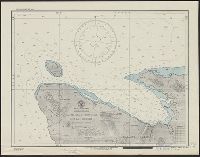
H.O. field chart ; no. 3011, H.O. field chart ; no. 3011., Malaita Island North Coast, and Suaba Harbor
Description:
"Printed May 1944, on board U.S.S. Pathfinder, for the U.S.S. Oceanographer, under authority of the Secretary of the Navy. Reprinted at the Hydrographic Office, June 1944.", "Soundings in fathoms.", and Stamped "Map and Chart Collection. Gift of Frances M., Per
Publisher:
U.S. Navy, Hydrographic Office,
Subject (Geographic):
Malaita Province (Solomon Islands)--Maps and South Pacific Ocean--Navigation--Maps