Skip to search
Skip to main content
Skip to first result
Search
You Searched For
Genre
Maps
Genre
Maps in books
New Search
Search Results
Call Number:
1976 1233
Collection Title:
Forty-two new maps of Asia, Africa, and America ... : all engrav’d, according to the latest
Image Count:
1
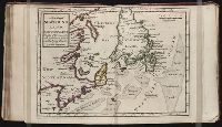
Alternative Title:
Newfoundland, New Scotland, &c
Description:
In pencil on verso: 38. and Table of contents for maps 2-20 in section "America" misnumbered.
Subject (Geographic):
New Brunswick --Maps, Newfoundland --Maps --Early works to 1800, and Nova Scotia --Maps --Early works to 1800
Subject (Name):
Nicholson, John, d. ca. 1717, bookseller
Subject (Topic):
Atlases --Early works to 1800
Collection Created:
London : Printed for J. Nicholson ..., 1716 ...
Found in:
Beinecke Rare Book and Manuscript Library > A new map of Newfound land, New Scotland the isles of Breton, Anticoste, St, Iohns &c. together with the fishing bancks
Call Number:
1976 1233
Collection Title:
Forty-two new maps of Asia, Africa, and America ... : all engrav’d, according to the latest
Image Count:
1
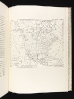
Alternative Title:
North America
Description:
In pencil on verso: 34. and Table of contents for maps 2-20 in section "America" misnumbered.
Subject (Geographic):
North America --Maps --Early works to 1800
Subject (Name):
Nicholson, John, d. ca. 1717, bookseller
Subject (Topic):
Atlases --Early works to 1800
Collection Created:
London : Printed for J. Nicholson ..., 1716 ...
Found in:
Beinecke Rare Book and Manuscript Library > A new map of North America according to the newest observations
Creator:
Published / Created:
1797
Call Number:
GA405 +W44 (LC)
Collection Title:
Mapping the transmississippi West, 1540-1861
Image Count:
1
Description:
Bound in between p. 150-151., Map 244 from table of contents., and Published in The American Gazetteer
Publisher:
Printed at the presses of S. Hall, and Thomas & Andrews
Subject (Geographic):
Canada--Maps, Mexico--Maps, and North America--Maps
Collection Created:
San Francisco, Institute of Historical Cartography, 1957-63
Found in:
Beinecke Rare Book and Manuscript Library > A new map of North America shewing all the new discoveries [facsimile]
Creator:
Published / Created:
1755
Call Number:
2003 Folio 85
Image Count:
1
Description:
BEIN 2003 Folio 85: No. 14 of 45 maps bound together with binder's spine title: Atlas of America; ms. table of contents. Bookplate: Robinson. Bookplate of Paul Mellon., Hand colored., Includes table of sources of observations., Relief shown pictorially. Depths shown by soundings., Scale [ca. 1:2,600,000]., Scale ca. 1:1,900,000;English marine leagues 20 to a degree; English miles 69 1/2 to a degree., and Shows Maritime Provinces, New England, and St. Lawrence Valley region to Montreal.
Publisher:
Thos. Jefferys
Subject (Geographic):
Canada -- Maps -- Early works to 1800, Maritime Provinces -- Maps -- Early works to 1800, New England -- Maps -- Early works to 1800, Nova Scotia -- Maps -- Early works to 1800, and Saint Lawrence River Valley -- Maps -- Early works to 1800
Found in:
Beinecke Rare Book and Manuscript Library > A new map of Nova Scotia, and Cape Britain: With the adjacent parts of New England and Canada, composed from a great number of actual surveys; and other materials regulated by many new astronomical observations of the longitude as well as latitude; with a
Call Number:
1976 1233
Collection Title:
Forty-two new maps of Asia, Africa, and America ... : all engrav’d, according to the latest
Image Count:
1
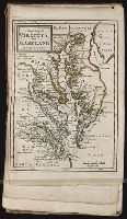
Alternative Title:
Virginia and Maryland
Description:
In pencil on verso: 41. and Table of contents for maps 2-20 in section "America" misnumbered.
Subject (Geographic):
Maryland --Maps --Early works to 1800 and Virginia --Maps --Early works to 1800
Subject (Name):
Nicholson, John, d. ca. 1717, bookseller
Subject (Topic):
Atlases --Early works to 1800
Collection Created:
London : Printed for J. Nicholson ..., 1716 ...
Found in:
Beinecke Rare Book and Manuscript Library > A new map of Virginia, and Maryland
Call Number:
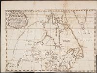
Zc90 +744do
Collection Title:
An account of the countries adjoining to Hudson's Bay, in the North-west part of America
Image Count:
1
Description:
Preceding title page. and Teaching resource: Professor John Mack Faragher, History 141: The American West.
Subject (Geographic):
Great Lakes (North America), Northwest Coast of North America, Northwest Passage, and Northwest, Canadian --Description and travel
Subject (Name):
Fuentes, Bartolome de, 17th cent, Hudson’s Bay Company, and Middleton, Christopher, d. 1770
Subject (Topic):
Fur trade --Canada and Indians of North America --Canada
Collection Created:
London : Printed for J. Robinson, 1744
Found in:
Beinecke Rare Book and Manuscript Library > A new map of part of North America from the latitude of 40 to 68 degrees. Including the late discoveries made on board the Furnace Bomb Ketch in 1742. And the western rivers & lakes falling into Nelson River in Hudson's Bay, as described by Joseph La Fran
Creator:
Published / Created:
1788 June 24
Call Number:
1982 Folio 10
Image Count:
2
Description:
Also appeared in Faden's [General atlas. London : William Faden, 1811?]., Hand-coloring of political borders differ from 1982 Folio 10, no. 20., No. 20 of 43 maps bound together in composite atlas., No. 21 of 43 maps bound together in composite atlas., Relief shown pictorially., and Scale [ca. 1:2,150,000].
Publisher:
William Faden
Subject (Geographic):
Europe --Maps --Early works to 1800, Germany --Administrative and political divisions --Maps --Early works to 1800, and Germany --Maps --Early works to 1800
Found in:
Beinecke Rare Book and Manuscript Library > A new map of the German empire and the neighbouring states with their principal post roads : originally published by the Royal Academy of Berlin
Creator:
Published / Created:
1789 June 1
Call Number:
1982 Folio 10
Image Count:
1
Description:
Also appeared in Faden's [General atlas. London : William Faden, 1811?]., No. 22 of 43 maps bound together in composite atlas., Relief shown pictorially., and Scale [ca. 1:565,000].
Publisher:
W. Faden
Subject (Geographic):
Germany --Maps --Early works to 1800
Subject (Name):
Brunswick-Luneburg, House of
Found in:
Beinecke Rare Book and Manuscript Library > A new map of the King of Great Britain's dominions in Germany or the electorate of Brunswick-Luneburg and its dependencies
Branch:v1.61.6 ,Deployed:2024-06-12T09:55:33-04:00