Skip to search
Skip to main content
Skip to first result
Search
You Searched For
Format
cartographic
Language
Spanish; Castilian
Publication Place
Buenos Aires :
New Search
Search Results
Published / Created:
[1944?]
Call Number:
30 1944B
Container / Volume:
BRBL_00032B
Image Count:
2
Resource Type:
Maps, Atlases & Globes
Publisher:
Montenegro Paz,
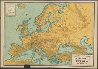
Subject (Geographic):
Europe--Maps
Found in:
Beinecke Rare Book and Manuscript Library > Gran Bretaña Baluarte de las Libertades Europa.
Published / Created:
[1912?].
Call Number:
935gme 1912
Container / Volume:
BRBL_00674
Image Count:
1
Resource Type:
Maps, Atlases & Globes
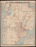
Description:
"VIII. Edicion.", Inset: Mapa de la Parte Sud de la Republica Argentina., Insets: Buenos Aires, Mendoza, Rosario, and Tucuman., and Mounted on linen.
Publisher:
[Publicado por la] Oficina Cartográfica de Pablo Ludwig,
Subject (Geographic):
Argentina--Maps, Chile--Maps, Paraguay--Maps, and Uruguay--Maps
Found in:
Beinecke Rare Book and Manuscript Library > Mapa de los ferrocarriles de la República Argentina, Chile, Uruguay y Paraguay.
Creator:
Published / Created:
1910
Call Number:
94 1910B
Container / Volume:
BRBL_00675
Image Count:
2
Resource Type:
Maps, Atlases & Globes
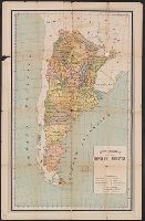
Alternative Title:
Argentine Republic in its first centennial year : 1810-1910
Description:
Complete panel text: "Official publication under the patronage of the Centenary Committee, the Argentine Republic in its first centennial year : 1810-1910 statistical and geographical information about the republic and its resources as a country adapted in every way for European immigration by Alberto B. Martinez, Buenos Aires 1910.", Imperfect. Mutilated with possible loss of text., Relief shown by hachures., and Text and tables on verso.
Publisher:
Centenary Committee, Argentine Republic,
Subject (Geographic):
Argentina--Maps
Found in:
Beinecke Rare Book and Manuscript Library > Mapa general de la República Argentina [cartographic material] / Alberto B. Martinez.
Published / Created:
[1941?]
Call Number:
11hd 1941M
Image Count:
2
Resource Type:
Maps, Atlases & Globes
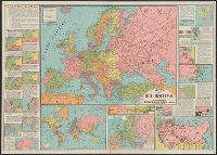
Alternative Title:
Mapa de Europa
Description:
18 ancillary maps with texts describing German, Italian, and Japanese expansions, Mapa de Europa -- Union Sovietica -- Europa Militar -- Planisferio., and Panel title.
Publisher:
Oficina Cartográfica Montenegro Paz,
Subject (Geographic):
Europe--Maps and Soviet Union--Maps
Found in:
Beinecke Rare Book and Manuscript Library > Mapas de la Guerra Mundial.
Published / Created:
1921
Call Number:
94cbf 1914
Container / Volume:
BRBL_00675
Image Count:
1
Resource Type:
Maps, Atlases & Globes
Alternative Title:
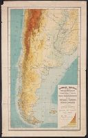
Mapa hipsométrico de la República Argentina y regiones limitrofes
Description:
Imperfect. Mutilated. Map torn in half along fold. and Reprint/reissue of map dated 1914?.
Publisher:
Dirección general de minas, geología e hidrología,
Subject (Geographic):
Argentina--Maps
Found in:
Beinecke Rare Book and Manuscript Library > Ministerio de agricultura, Dirección general de minas, geología e hidrología : Mapa hipsométrico de la República Argentina y regiones limitrofes / construido en la seccion topografia con los datos de su archivo.
Published / Created:
.
Call Number:
9417 1913M
Container / Volume:
BRBL_00675
Image Count:
1
Resource Type:
Maps, Atlases & Globes
Alternative Title:
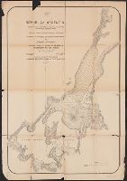
Plano de los distritos mineros Hombre Muerto-Diablillos y Ratones
Description:
Imperfect. Mutilated with possible loss of text.
Publisher:
Dirección General de Minas, Geología é Hidrología,
Subject (Geographic):
Argentina--Maps
Found in:
Beinecke Rare Book and Manuscript Library > República Argentina : Informe sobre el estado de la minería en el territorio de los Andes / por ... Luciano Caplain.
Branch:v1.61.8 ,Deployed:2024-06-20T11:14:46-04:00