Skip to search
Skip to main content
Skip to first result
Search
You Searched For
Extent of Digitization
Completely digitized
Format
cartographic
Genre
Manuscript maps
New Search
Search Results
Published / Created:
1758
Call Number:
7325 L93 1758A
Container / Volume:
BRBL_00709
Image Count:
1
Resource Type:
Maps, Atlases & Globes
Description:
Color: ink drawing with red, green and gold color. and Photostat included in folder.
Subject (Geographic):
Louisbourgh (N.S.)--Maps, Manuscript--Early works to 1800
Found in:
Beinecke Rare Book and Manuscript Library > A Plan of the Town and Harbour of Louisburg ... 1758. By Lieut. Joseph Norwood.
Published / Created:
[1780]
Call Number:
29cea 1780
Container / Volume:
BRBL_00701
Image Count:
1
Resource Type:
Maps, Atlases & Globes
Description:
Manuscript map.
Subject (Geographic):
Indian Ocean--Maps, Manuscript--Early works to 1800
Found in:
Beinecke Rare Book and Manuscript Library > A Plane Chart of several Islands Bank Shoals & Soundings ...
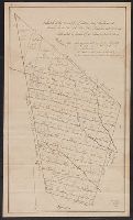
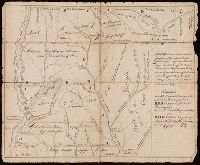
Published / Created:
[1750?]
Call Number:
763fb Su87 1750
Container / Volume:
BRBL_00710
Image Count:
1
Resource Type:
Maps, Atlases & Globes
Description:
Color: pen and ink drawing. and Note located in upper right hand corner.
Subject (Geographic):
Vermont--Maps, Manuscript--Early works to 1800
Found in:
Beinecke Rare Book and Manuscript Library > A Sketch of the Township of Sutton, lately Billymead, showing the number of the lot and to which propietor each lot is rett.
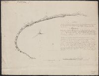
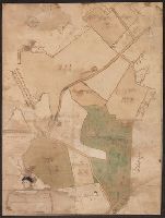
Published / Created:
1785
Call Number:
648cea Sa23 1785
Container / Volume:
BRBL_00708
Image Count:
1
Resource Type:
Maps, Atlases & Globes
Description:
Color: pen and pencil drawing., Preliminary record., and Reference key on right hand side and note describing the area.
Subject (Geographic):
Cape of Good Hope (South Africa)--Maps, Manuscript--Early works to 1800
Found in:
Beinecke Rare Book and Manuscript Library > A chart of a bay [St. Francis Bay?] on the SE coast of Africa ... 1785 ... in Lat. 34°09'S, Long 26°10'E.
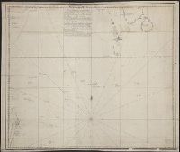
Published / Created:
[ca. 1758]
Call Number:
732cea 1758
Container / Volume:
BRBL_00709
Image Count:
1
Resource Type:
Maps, Atlases & Globes
Description:
Inscription: "All this part of the peninsula from Cape Sable to the Mahone Bay abounds with oaks, pine, large firs and black Birch and has a rich and fertile soil and many fine rivers and harbours.", Preliminary record., and Table of latitude and longitude in b
Subject (Geographic):
Nova Scotia--Maps, Manuscript--Early works to 1800
Found in:
Beinecke Rare Book and Manuscript Library > A chart of the peninsula of Nova Scotia by Charles Morris.
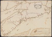
Published / Created:
ca. 1705]
Call Number:
732cea C413 1705
Container / Volume:
BRBL_00709
Image Count:
1
Resource Type:
Maps, Atlases & Globes
Subject (Geographic):
Chedabucto Bay (N.S.)--Maps--Early works to 1800
Found in:
Beinecke Rare Book and Manuscript Library > A draught of Southacks Bay in America [cartographic material].
Published / Created:
[1715?]
Call Number:
53 1700
Container / Volume:
BRBL_00707
Image Count:
1
Resource Type:
Maps, Atlases & Globes
Description:
Color: green and gray water color. and Manuscript chart on vellum. With inset profiles of a number of landmarks.
Subject (Geographic):
Middle East--Maps, Manuscript--Early works to 1800
Found in:
Beinecke Rare Book and Manuscript Library > A large draught of the Red Sea from Mount Felix to Judda.
Published / Created:
April 1759.
Call Number:
773 C884 1759
Container / Volume:
BRBL_00714
Image Count:
1
Resource Type:
Maps, Atlases & Globes
Description:
Plantation in vicinity of Crosswicks (N.J.).
Subject (Geographic):
Crosswicks (N.J.)--Maps--Early works to 1800
Subject (Topic):
Plantations--New Jersey--Crosswicks--Maps--Early works to 1800
Found in:
Beinecke Rare Book and Manuscript Library > A map of Isaac Cowgill's plantation : contain two hundred & seven acres and twenty perches / by Jno. Oliver.
Published / Created:
[1789]
Call Number:
BrSides 2017 121
Image Count:
2
Resource Type:
Maps, Atlases & Globes
Description:
Coordinates not present on map and are approximated., From the Nathaniel Pendleton family papers., Imperfect: torn along folds, with some loss of text., Relief shown by hachures., and Shows locations and number of warriors for the Chickasaw and Choctaw Indian tribes.
Subject (Geographic):
Chickasaw Nation--Maps--Early works to 1800., Choctaw Nation--Maps--Early works to 1800., and Mississippi--Maps--Early works to 1800.
Subject (Name):
Cox, Zachariah, Pendleton, Nathaniel,--1756-1821--Ownership., South-Carolina Yazoo Company, Tennessee Company, and Virginia Yazoo Company
Subject (Topic):
Public lands--Georgia--Early works to 1800., Real property--Mississippi--Maps--Early works to 1800., and Yazoo Fraud, 1795--Maps--Early works to 1800.
Found in:
Beinecke Rare Book and Manuscript Library > A map of lands purchased of the state of Georgia in 1789, by the South Carolina Yazou Company, by the Virginia Yazou Company, and by the Tennessee Company / sketched from a map of Zachariah Coxe's Esq., who made it from an actual survey of these counties; this draught, although coarsely done, is exact, and consonant the scale adopted by the said Coxe.
Published / Created:
[ca. 1746]
Call Number:
7325 L93 1746
Container / Volume:
BRBL_00709
Image Count:
1
Resource Type:
Maps, Atlases & Globes
Description:
Color: pale blue, rose and yellow., Includes a negative photostat., and Notes: key in bottom right hand corner.
Subject (Geographic):
Louisbourg (N.S.)--Maps, Manuscript--Early works to 1800
Found in:
Beinecke Rare Book and Manuscript Library > A plan of Louisbourg intended only to shew by strong red the publick buildings lately erected, and by faint red such as have had a thorough repair. I.H. Bastide.
Branch:v1.61.8 ,Deployed:2024-06-20T11:15:04-04:00