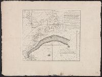
Described as an untitled French translation of an unknown Mount and Page chart annotated by Benjamin Franklin in preparation for publication in London in De Vorsey's Imago mundi article. and Includes text, shows latitude and longitude figures in right and bot
Publisher:
Chéz Le Rouge, rue des Grands Augustine ...,
Subject (Geographic):
Gulf Stream--Maps--Early works to 1800
Subject (Name):
Franklin, Benjamin, 1706-1790
Subject (Topic):
Nautical charts--Atlantic Coast (North America)--Early works to 1800
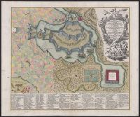
Sÿmbolische sinnreiche in einer Balagerung u. Bombardirung entworffene Vorstellung wie man den anfällen und Versuchungen der Liebe klug und tapffer zu begegnen
Description:
"Cum gratia et privil. S.R.I. Vicariatus, in partibus Rheni, Sueviae, et Juris Franconici.", Includes text, ill., and decorative cartouche., Pictorial bird's-eye view., Place names in French. Title and legend in French and German., and Relief shown by hachures.
Publisher:
M. Seutter,
Subject (Topic):
Imaginary places--Aerial views--Early works to 1800
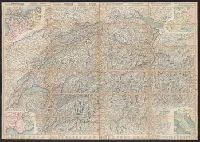
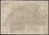
Carta stradale della Svizzera, Carte routière de la Suisse, Reisekarte der Schweiz, and Road map of Switzerland
Description:
In French. Legend and scales in French, English, German, and Italian., Includes insets of northwestern Europe, north-central Europe, northern Italy, and the French-Italian coastal, and Mounted on verso: Luzern -- Bâle -- Genève -- Zuric -- Berne -- Lausanne.
Carta stradale della Svizzera, Carte routière de la Suisse, Reisekarte der Schweiz, and Road map of Switzerland
Description:
In French. Legend and scales in French, English, German, and Italian., Includes insets of northwestern Europe, north-central Europe, northern Italy, and the French-Italian coastal region., Mounted on verso: Luzern, and Relief shown by hachures and spot heights.
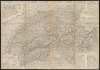
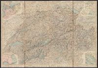
Carta stradale della Svizzera, Carte routière de la Suisse, Reisekarte der Schweiz, and Road map of Switzerland
Description:
In French. Legend and scales in French, English, German, and Italian., Includes insets of northwestern Europe, north-central Europe, northern Italy, and the French-Italian coastal region., Library copy annotated in, and Relief shown by hachures and spot heights.
Carta stradale della Svizzera, Carte routière de la Suisse, Reisekarte der Schweiz, and Road map of Switzerland
Description:
In French. Legend and scales in French, English, German, and Italian., Includes insets of northwestern Europe, north-central Europe, northern Italy, and the French-Italian coastal region., and Mounted on verso: Luzern -- Bâle -- Genève -- Zuric -- Berne -- La