Skip to search
Skip to main content
Skip to first result
Search
You Searched For
Date
Unknown
Extent of Digitization
Completely digitized
Format
cartographic
Date Created
[Missing]
New Search
Search Results
Call Number:
777 C425 1799
Container / Volume:
BRBL_00503
Image Count:
1
Resource Type:
Maps, Atlases & Globes
Description:
Allardice sc. and Inset: Plan of the town of Havre de Grace.
Subject (Geographic):
Chesapeake Bay (Md. and Va.)--Maps--Early works to 1800
Found in:
Beinecke Rare Book and Manuscript Library > A map of the head of the Chesapeake Bay and Susquehanna River shewing the navigation of the same with a topographical description of the surrounding country from an actual survey by C.P. Hauducoeur 1799.
Call Number:
783 1775
Container / Volume:
BRBL_00507
Image Count:
3
Resource Type:
Maps, Atlases & Globes
Description:
Drawn by Joshua Fry & Peter Jefferson 1775. and Pos. photostat and negative.
Publisher:
Thos Jefferys & Robt. Sayer.
Subject (Geographic):
Virginia--Maps--Early works to 1800
Found in:
Beinecke Rare Book and Manuscript Library > A map of the most inhabited part of Virginia part of Pensilvania, new Yersey & North Carolina.
Call Number:
735 1790
Container / Volume:
BRBL_00689
Image Count:
1
Resource Type:
Maps, Atlases & Globes
Alternative Title:
Map showing the communication of the lakes and the rivers between Lake Superior and Slave Lake in North America
Description:
"Gent. Mag. March 1790, Pl. I, p. 197" in upper right hand corner., Mounted on linen. Sheet measures 20.7 x 24.3 cm. Cross Collection no. 178., Prime meridian: London., and Relief shown by hachures.
Publisher:
s.n., 1790?]
Subject (Geographic):
Canada--Maps--Early works to 1800 and North America--Maps--Early works to 1800
Found in:
Beinecke Rare Book and Manuscript Library > A map shewing the communication of the lakes and the rivers between Lake Superior and Slave Lake in North America.
Creator:
Call Number:
623 1750
Container / Volume:
BRBL_00333
Image Count:
1
Resource Type:
Maps, Atlases & Globes
Alternative Title:
Nubia & Abissinia
Description:
From Bowen's A complete system of geography, 1747., Includes text and ill., and Relief shown pictorially.
Publisher:
Printed for W. Innys, R. Ware [etc.], 1747]
Subject (Geographic):
Africa, Eastern--Maps--Early works to 1800 and Africa, North--Maps--Early works to 1800
Subject (Name):
Bowen, Emanuel, d. 1767. Complete system of geography
Found in:
Beinecke Rare Book and Manuscript Library > A new and accurate map of Nubia & Abissinia, together with all the kingdoms tributary thereto, and bordering upon them / laid down from the latest & best authorities and regulated by astronl. observations ny Emanl. Bowen.
Creator:
Call Number:
Lanman 11 1659A
Image Count:
1
Resource Type:
Maps, Atlases & Globes
Alternative Title:
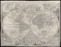
New and accurat map of the world and New and accurate map of the world
Description:
Attributed to Robert Walton; based on a map by John Speed., From Denis Petau's History of the world (1659)., Includes insets of "The heavens and elements," "The eclipse of the sunn," "A figure of the spheare," and "The eclipse of the moone," 2 celestial hemispheres, historical notes, and illustrations., Relief shown pictorially., Shows California as an island., and Watermark.
Subject (Name):
Petau, Denis, 1583-1652 and Speed, John, 1552?-1629
Subject (Topic):
World maps--Early works to 1800
Found in:
Beinecke Rare Book and Manuscript Library > A new and accvrat map of the world : drawne according to ye truest descriptions latest discoveries & best observations y[e]t have beene made by English or strangers.
Creator:
Call Number:
304 1712
Container / Volume:
BRBL_00033
Image Count:
1
Resource Type:
Maps, Atlases & Globes
Alternative Title:
General Diet of the Empire, or its Parliament.
Description:
Inset illustration of the Reichstag of Holy Roman Empire, with title: The General Diet of the Empire, or it's Parliament.
Subject (Geographic):
Europe, Central--Maps--Early works to 1800, Germany--Maps--Early works to 1800, Hungary--Maps--Early works to 1800, Romania--Maps--Early works to 1800, and Switzerland--Maps--Early works to 1800
Subject (Name):
Holy Roman Empire.--Reichstag and Hughes, Thomas Lowe,--1925---Ownership
Found in:
Beinecke Rare Book and Manuscript Library > A new map of Germany, Hungary, Transilvania & the Suisse cantons : with many remarks not extant in any map : according to ye newest and most exact observations / by Herman Moll, geographer.
Creator:
Call Number:
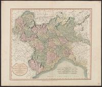
401 1811
Container / Volume:
BRBL_00233
Image Count:
1
Resource Type:
Maps, Atlases & Globes
Description:
Hand colored. Stamp: Karpinski-von Wieser Map Collection. Label: 17., Meridian: Greenwich., and Relief shown by hachures.
Subject (Geographic):
Genoa (Italy : Province)--Maps, Milan (Italy : Province)--Maps, Piedmont (Italy)--Maps, and Savoy (France and Italy)--Maps
Found in:
Beinecke Rare Book and Manuscript Library > A new map of Piedmont, the duchies of Savoy and Milan, and the republic of Genoa, with their subdivisions : from the latest authorities / by John Cary.
Creator:
Call Number:
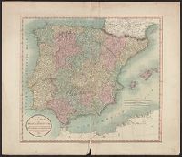
39 1801
Container / Volume:
BRBL_00186
Image Count:
1
Resource Type:
Maps, Atlases & Globes
Description:
Appeared in Cary's new universal atlas, London, 1808. and Relief shown pictorially.
Subject (Geographic):
Portugal--Maps and Spain--Maps
Subject (Name):
Cary, John, ca. 1754-1835. Cary's new universal atlas and Hughes, Thomas Lowe,--1925---Ownership
Found in:
Beinecke Rare Book and Manuscript Library > A new map of Spain and Portugal : divided into their respective kingdoms and provinces from the latest authorities / by John Cary, engraver.
Creator:
Call Number:
3614 1799
Container / Volume:
BRBL_00135
Image Count:
1
Resource Type:
Maps, Atlases & Globes
Description:
Appeared in Cary's New universal atlas, London, 1808., Covers East Prussia., and Printed on verso: 36.
Subject (Geographic):
Prussia, East (Poland and Russia)--Maps--Early works to 1800
Subject (Name):
Cary, John, approximately 1754-1835. Cary's new universal atlas and Hughes, Thomas Lowe,--1925---Ownership
Found in:
Beinecke Rare Book and Manuscript Library > A new map of the Kingdom of Prussia : with its divisions into provinces and governments ; from the latest authorities / by John Cary, engraver, 1799.
Creator:
Call Number:
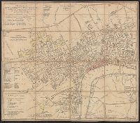
32 L84 1766
Container / Volume:
BRBL_00048
Image Count:
1
Resource Type:
Maps, Atlases & Globes
Subject (Geographic):
London (England)--Maps--Early works to 1800 and Westminster (London, England)--Maps--Early works to 1800
Found in:
Beinecke Rare Book and Manuscript Library > A new plan of the city and liberty of Westminster ... / drawn & engraved by Thomas Jefferys ...
Branch:v1.61.6 ,Deployed:2024-06-12T09:55:37-04:00