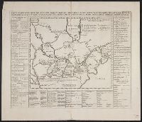
Above neat line at right: Tom VI. no. 21 pag: 90., Chatelain copy of Lahontan's 1703 map of Canada., From Chatelain's Atlas historique ... Amsterdam : Chez François L'Honoré & Compagnie ..., [1719], Map bordered by, and Sheet measures 45.2 x 52.9 cm.
Publisher:
Henri Abraham Chatelain,
Subject (Geographic):
Canada--Maps--Early works to 1800 and Great Lakes (North America)--Maps--Early works to 1800
Subject (Name):
Chatelain, Henri Abraham. Atlas historique and Lahontan, Louis Armand de Lom d'Arce, baron de, 1666-1715?
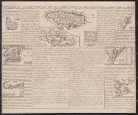
Carte de la Jamaique [with inset of Gulf of Mexico and Caribbean Area] -- Ile des Barbades -- Nouve, Mounted on linen. Sheet measures 44.6 x 53.3 cm. Cross Collection no. 153., Probably from Chatelain's Atlas historique, 1705-1720., and Relief shown pictorially.
Publisher:
Chez l'Honoré & Châtelain Libraires?,
Subject (Geographic):
Caribbean Area--Maps--Early works to 1800, Great Britain--Colonies--America--Maps--Early works to 1800, and North America--Maps--Early works to 1800
Description, situation and vue de la ville de Mexique
Description:
"Tom: VI. No. 28. Pag: 110.", Caption title., Carte du Mexique -- Environs du Lac de Mexique., From Chatelain's Atlas historique ... [v. 6, no. 28, p. 110] Amsterdam : Chez L'Honoré & Châtelain, 1718-21., and Includes ill. and text, "La Province de Mexique ... & plus de 100, mille Esclaves."
Publisher:
L'Honoré & Châtelain,
Subject (Geographic):
Mexico City (Mexico)--Maps--Early works to 1800 and Mexico--Maps--Early works to 1800
Insulae Americanae in Oceano Septentrionali cum terris adjacentibus and Insvlae Americanae in Oceano Septentrionali cum terris adiacentibus
Description:
Cf. Burden, P.D. Mapping of North America, 242., Cf. Koeman, C. Atlantes Neerlandici (1997 ed.), II, p. 600 (map 9600:2B)., Includes dedication to "D. Alberto Conradi Vander Burch" signed "tabulam hanc inscribit Guiljelmus Blaeu.", Includes embellished title cartouche, dedication with coats-of-arms, scale and ill. of ships at sea., and Includes scales in milliaria germanica and milliaria hispanica.
Publisher:
s.n.,
Subject (Geographic):
Caribbean Area--Maps--Early works to 1800, Mexico, Gulf of--Maps--Early works to 1800, and West Indies--Maps--Early works to 1800
Subject (Topic):
Coasts--North America--Maps--Early works to 1800 and Coasts--South America--Maps--Early works to 1800
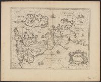
Insulae Americanae in Oceano Septentrionali cum terris adjacentibus
Description:
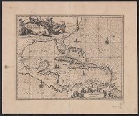
An unrecorded reduced version of Blaeu's map, where the cherub decorations on the cartouche and scale have been replaced by Native Americans, West Indians and Europeans. Coastlines vary sligh and Includes scales in milliaria germanica and milliaria hispanica.
Publisher:
s.n.,
Subject (Geographic):
Caribbean Area--Maps--Early works to 1800, Mexico, Gulf of--Maps--Early works to 1800, and West Indies--Maps--Early works to 1800
Subject (Topic):
Coasts--North America--Maps--Early works to 1800 and Coasts--South America--Maps--Early works to 1800
Insulae Americanae in Oceano Septentrionali cum terris adjacentibus and Insvlae Americanae in Oceano Septentrionali cum terris adiacentibus
Description:
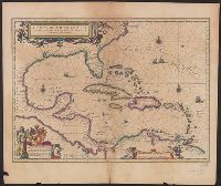
From Willem Janszoon and Joan Blaeu's Theatrum orbis terrarum ... Amsterdami : Apud Guiljelmum et Iohannem Blaeu, 1635., Includes dedication to "D. Alberto Conradi Vander Burch" signed "tabulam hanc inscribit Guiljelmus Blaeu.", Includes embellished title cartouche, dedication with coats-of-arms, scale and ill. of ships at sea., and Includes scales in milliaria germanica and milliaria hispanica.
Publisher:
s.n.,
Subject (Geographic):
Caribbean Area--Maps--Early works to 1800, Mexico, Gulf of--Maps--Early works to 1800, and West Indies--Maps--Early works to 1800
Subject (Name):
Blaeu, Joan, 1596-1673. Theatrum orbis terrarum and Blaeu, Willem Janszoon, 1571-1638. Theatrum orbis terrarum
Subject (Topic):
Coasts--North America--Maps--Early works to 1800 and Coasts--South America--Maps--Early works to 1800
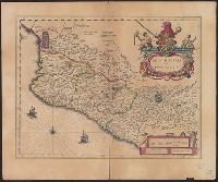
Bar scale given in "milliaria Hispanica.", Cross Collection no. 311., From Blaeu's Le theatre du monde ... Amsterdami : Apud Guiljelmum et Iohannem Blaeu, 1635., Imperfect: torn half-way along fold., In French on verso, with caption title "La novvelle Espagne" and signature C6., Includes "Notarum explanatio" and ill., and Relief shown pictorially.
Publisher:
Willem and Joan Blaeu,
Subject (Geographic):
Mexico--Maps--Early works to 1800
Subject (Name):
Blaeu, Joan, 1596-1673. Theatrum orbis terrarum. French and Blaeu, Willem Janszoon, 1571-1638. Theatrum orbis terrarum. French