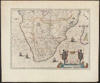
"Partes magis Septentrionales, quae hic desiderantur, vide in tabula Aethiopiae Superioris.", From the author's Theatre, Includes col. ill. of animals and ships, and decorative cartouche., Map text in Latin. Text on verso in French., and Relief shown pictorially.
Publisher:
Chez Iean Blaeu,
Subject (Geographic):
Africa, Southern--Maps--Early works to 1800
Subject (Name):
Blaeu, Joan, 1596-1673 and Blaeu, Willem Janszoon, 1571-1638. Theatrum orbis terrarum. French
Includes col. ill. of ships, monsters, etc., Possibly from the 1639, 1641, or 1642 ed. of the author's Noveau theatre du monde ou nouvel atlas, or from the 1646, 1647, or 1649 ed. of J. Jansson's Nouvel atlas ou theatre du monde., and Relief shown pictorially.
Appears in Blaeu's Atlas major, Fre, Hand col. Sheet measures 54 x 63 cm. Lanman Collection., Russian, Latin and French., Title text in cyrillic; transliteration in Koeman., and Verso: Title "Moskow, ville metropolitaine de Moscovie"; pg. no. 20,b; signature F 2.
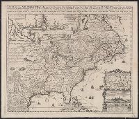
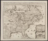
Appears in Chatelain's Atlas historique according to McCorkle., Cross collection no. 149., In upper right: Tom: VI. No: 23. Pag: 91., Includes notes, table of coordinates for certain locations, and ill., and Insets: Les environs de Quebec -- Veüe de Quebec -- Les costes de la Louisiane.
Publisher:
Chez L'Honoré & Châtelain Libraires?,
Subject (Geographic):
New France--Maps--Early works to 1800 and North America--Maps--Early works to 1800
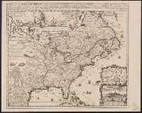
Appears in Chatelain's Atlas historique according to McCorkle., Cross collection no. 149., In upper right: Tom: VI. No: 23. Pag: 91., Includes notes, table of coordinates for certain locations, and ill., McCorkle attributes authorshi, and Relief shown pictorially.
Publisher:
Chez L'Honoré & Châtelain Libraires?,
Subject (Geographic):
New France--Maps--Early works to 1800 and North America--Maps--Early works to 1800
Appears in Chatelain's Atlas historique according to McC, In upper right: Tom: VI. No: 23. Pag: 91., Includes notes, table of coordinates for certain locations, and ill., McCorkle attributes authorship of this map to Nicolas de Fer., and Relief shown pictorially.
Publisher:
Chez L'Honoré & Châtelain Libraires?,
Subject (Geographic):
New France--Maps--Early works to 1800 and North America--Maps--Early works to 1800
Based on Guillaume de L'Isle's Carte du Canada ... 1703., From Chatelain's Atlas historique ... Amsterdam : Chez L'Honoré & Châtelain, 1718-21., In upper right corner: Tom: VI. No: 20. Pag: 82., Includes text., Reli, and Sheet measures 45.3 x 57.1 cm.
Publisher:
Chez l'Honore & Chatelain Libraires,
Subject (Geographic):
Canada--Maps--Early works to 1800 and New France--Maps--Early works to 1800
"Avec privil.", Backed with paper. Ms. no. "97" in upper right-hand corner. Sheet measures 53.6 x 63.5 cm. No. 87 of 87 maps bound together., Includes four bar scales., Includes inset: Carte particulière du Détroit de Magellan., Relief shown pictorially., and Untitled inset shows Southern Hemisphere.
Publisher:
Elizabeth Visscher,
Subject (Geographic):
Magellan, Strait of (Chile and Argentina)--Maps--Early works to 1800., South America--Maps--Early works to 1800., and Southern Hemisphere--Maps--Early works to 1800.
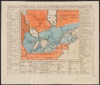
Above neat line at right: Tom VI. no. 21 pag: 90., Chatelain copy of Lahontan's 1703 map of Canada., Fr, Hand col. Mounted on linen. Sheet measures 43.8 x 51.8 cm. Cross Collection no. 190., and Map bordered by tables listing Indian nations and animals of Canada.
Publisher:
Henri Abraham Chatelain,
Subject (Geographic):
Canada--Maps--Early works to 1800 and Great Lakes (North America)--Maps--Early works to 1800
Subject (Name):
Chatelain, Henri Abraham. Atlas historique and Lahontan, Louis Armand de Lom d'Arce, baron de, 1666-1715?