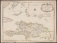
"Lieues marines Francoises de 20 au degré. Lieues communes de France de 25 au degré. Lieues Espagnoles de 17 1/2 au degré.", "Marin sculpsit.", Cross Collection no. 270., Hand col., Ms. nos. on verso: 94; 21., and Relief shown pictorially.
Publisher:
Chez l'Auteur sur le Quay de l'Horloge ...,
Subject (Geographic):
Bahamas--Maps--Early works to 1800, Hispaniola--Maps--Early works to 1800, and Turks and Caicos Islands--Maps--Early works to 1800
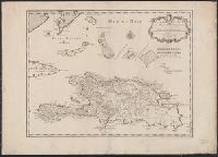
"Lieues marines Francoises de 20 au degré. Lieues communes de France de 25 au degré. Lieues Espagnoles de 17 1/2 au degré.", "Marin sculp, Mounted on linen. Sheet measures 57.7 x 80.9 cm. Ms. no. on verso (beneath linen): No. 9., and Relief shown pictorially.
Publisher:
Chez l'Auteur sur le Quay de l'Horloge ...,
Subject (Geographic):
Bahamas--Maps--Early works to 1800, Hispaniola--Maps--Early works to 1800, and Turks and Caicos Islands--Maps--Early works to 1800
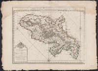
Bar scales given in "Lieues Marines de France et d'Angleterre de 20 au Deg.," "Lieues Marines et d'Espagne de 17 1/2 au Degré" and "Lieues Com. de France dont 25 font un Degré.", Ms. no. on verso: 7, and Prime meridian: Ferro.
Publisher:
Chez la Vve. du Sr. Delisle, sur le Quay del'Horloge,
Subject (Geographic):
Martinique--Maps--Early works to 1800
Subject (Name):
Buache, Philippe, 1700-1773 and Delahaye, Jean Baptiste Henri, engraver
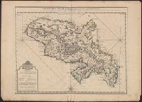
"Delahaye, sculpsit.", Bar scales given in "Lieues Marines de France et d'Angleterre de 20 au Deg.," "Lieues Marines et d'Espagne de 17 1/2 au Degré" and "Lieues Com. de France dont 25 font un Degré.", Legend in French and Dutch., Prime meridian: Ferro., and Shows settlements, mills, roads, anchorages, rivers, etc.
Publisher:
Chez la Vve. du Sr. Delisle, sur le Quay del'Horloge,
Subject (Geographic):
Martinique--Maps--Early works to 1800
Subject (Name):
Buache, Philippe, 1700-1773 and Delahaye, Jean Baptiste Henri, engraver
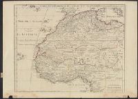
"Avec privil, "The words 'premier geographe du Roi' added in the title ... [indicate] that [a map] could not have been issued before 1718 when [De l'Isle] was appointed to that office"--Tooley, R.V. Guide to maps of Africa, p. 68., and Relief shown pictorially.
Publisher:
chez l'auteur fur le Quai de l'Horloge a l'Aigle d'Or,
Subject (Geographic):
Africa, North--Maps--Early works to 1800 and Africa, West--Maps--Early works to 1800
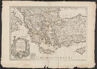
Bar scales given in "milles de Turquie," "lieues marines de France," and "lieues com[m]unes de France"., Covers also Albania, Macedonia and parts of Turkey, Cyprus, Bulgaria, Serbia, Montenegro and Bosnia., O, Prime meridian: Ferro., and Relief shown pictorially.
Publisher:
Chez l'Auteur ...,
Subject (Geographic):
Balkan Peninsula--Maps--Early works to 1800, Cyprus--Maps--Early works to 1800, Greece--Maps--Early works to 1800, and Turkey--Maps--Early works to 1800
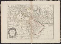
Hand col. in outlines only. Sheet measures 58.2 x 79.8 cm., Includes five bar scales., Prime meridian: Ferro., Relief shown pictorially., and Watermark.
Publisher:
Chez l'Auteur ...,
Subject (Geographic):
Africa, Northeast--Maps--Early works to 1800 and Middle East--Maps--Early works to 1800
Hand col. Mounted on linen. Sheet measures 65 x 49 cm. Ms. n, Has watermarks., Includes index and ill., Oriented with north to the bottom., Relief shown by hachures. Depths shown by soundings., and Shows fortifications and coastal defenses in the Gibraltar region.
Publisher:
Chez Basset, rue St. Jacques, au coin de delle des Mathurins,
Subject (Geographic):
Gibraltar, Bay of (Spain)--Maps--Early works to 1800
Subject (Name):
Coquart, A
Subject (Topic):
Coast defenses--Spain--Gibraltar, Bay of--Maps--Early works to 1800 and Fortification--Spain--Gibraltar, Bay of--Maps--Early works to 1800