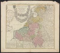
Carte des XVII. provinces ou de l'Allemagne inferievre, dresseé suivant la projection stereographique, et appüyée par les mesures faites de Mess. Cassini, Snellius et Mouschenbrok, par Mr. Tob. Majer de la Societé geographique, et publiée par les Her
Description:
Includes coat-of-arms and 5 bar scales., Relief shown pictorially., Sheet measures 54.6 x 61.5 cm., and Title in Latin and French; legend in Latin.
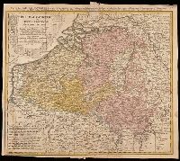
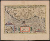
Belgium Catholicum seu decem provinciae Germaniae inferioris and Carte des Pais Bas catholiques où des X provinces de l'Allegmagne inférieure, etc. dessinée au juste selon les exactes observations astronomiques et opérations géometriques des Messur. Cass
Description:
"Avec privil. Imperial" above neat line., Includes 8 bar scales., Includes coats-of-arms of ten provinces., Relief shown pictorially., and Watermark. Manuscript number in upper right corner: 262[?]. From the Karpinski-von Wieser Map Collection.
Publisher:
Edentibus Homannianis heredib.,
Subject (Geographic):
Belgium--Maps--Early works to 1800. and Luxembourg--Maps--Early works to 1800.
Subject (Name):
Cassini, César-François, 1714-1784, Homann Erben (Firm), and Snellius, Willebrord, 1580-1626
[Atlas factice of 42 maps, produced by the Homann Erben firm]
Image Count:
1
Resource Type:
Maps, Atlases & Globes
Alternative Title:
Belgium Catholicum seu decem provinciae Germaniae inferioris and Carte des Pais Bas catholiques ou des X provinces de l’Allegmagne inferieure, etc. dessinee au juste selon les exactes observations astronomiques et operations geometriques des Messur. Cassini, Snellius, Muschenbrok, etc. dressee par Sr. Tobias Maier, mathematicien; aux depens des Heritiers de Homann
Publisher:
Edentibus Homannianis heredib
Subject (Geographic):
Belgium --Maps --Early works to 1800 and Luxembourg --Maps --Early works to 1800
Appears in Blaeu's Atlas major, Fre, Hand col. Sheet measures 54 x 63 cm. Lanman Collection., Russian, Latin and French., Title text in cyrillic; transliteration in Koeman., and Verso: Title "Moskow, ville metropolitaine de Moscovie"; pg. no. 20,b; signature F 2.
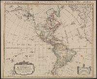
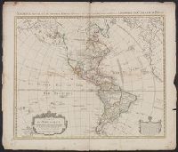
America accurate in imperia, regna, status, et populos divisa, ad usum Ludovici XV. Galliarum Regis
Description:
In French, with additional title in Latin., Includes "Avertissement"., Relief shown pictorially., and Sheet measures 51.5 x 63 cm. Numbered "108" in ink ms. Franklin Collection.
Publisher:
Chez Covéns & Mortier & Covéns Junior,
Subject (Geographic):
America--Maps--Early works to 1800
Subject (Name):
Anville, Jean Baptiste Bourguignon d', 1697-1782, Condet, Johannes, 1711-1781, engraver, and Covens et Mortier et Covens, junior
America accurate in imperia, regna, status, et populos divisa, ad usum Ludovici XV. Galliarum Regis
Description:
In French, with additional title in Latin., Includes "Avertissement"., Relief shown pictorially., and Sheet measures 58.5 x 69 cm. Stamp on verso: "Yale Horace Brown 1900S".
Publisher:
Chez Covéns & Mortier & Covéns Junior,
Subject (Geographic):
America--Maps--Early works to 1800
Subject (Name):
Anville, Jean Baptiste Bourguignon d', 1697-1782, Condet, Johannes, 1711-1781, engraver, and Covens et Mortier et Covens, junior
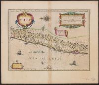
Cross Collection no. 347., From Blaeu's Le theatre du monde ... Amsterdami : Apud Guiljelmum et Iohannem Blaeu, 1635., Hand col., In French on verso, with caption title "Chili" and signature 7M., and Oriented with north to the left.
Publisher:
Guiljelmus Blaeuw excudit,
Subject (Geographic):
Chile--Maps--Early works to 1800
Subject (Name):
Blaeu, Joan, 1596-1673. Theatrum orbis terrarum. French and Blaeu, Willem Janszoon, 1571-1638. Theatrum orbis terrarum. French
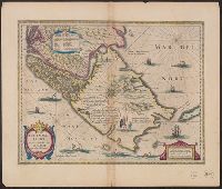
"Amsteledami, Io. Blaeu exc.", Hand col. Sheet measures 50.5 x 58.5 cm. Stamp on verso: Horace Brown 1900S., Plate 2 in French editions of Blaeu's Atlas major, vol. 12, published 1663 and 1667 (Burden 474)., Relief shown pictorially., S, and Signature on verso: A.
Bar scales in "Miliaria Germanica communia" and "Miliaria Gallica communia.", From Blaeu's Le theatre du monde ... Amsterdami : Apud Guiljelmum et Iohannem Blaeu, 1635., In French on verso, with caption title "Le Destroict de Magellanes, & celuy de la Maire" and signature 7L., and Relief shown pictorially.
Publisher:
Guiljelmus Blaeuw excudit,
Subject (Geographic):
Magellan, Strait of (Chile and Argentina)--Maps--Early works to 1800
Subject (Name):
Blaeu, Joan, 1596-1673. Theatrum orbis terrarum. French, Blaeu, Willem Janszoon, 1571-1638. Theatrum orbis terrarum. French, and Gryp, Dirck, engraver
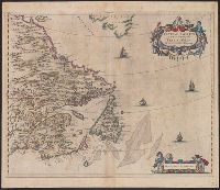
From the author's Gerardi Mercatoris atlas. 1628., Inset: I. S. Thomae., Map text in Latin. Text on verso in French., Relief shown pictorially., and Text on verso titled "Guinee, avec les isles de S. Thomas, du Prince, et d'Anobon," p. 637 and 640.
Publisher:
Sumptibus & typis aeneis Henrici Hondij,
Subject (Geographic):
Africa, West--Maps--Early works to 1800
Subject (Name):
Hondius, Hendrik, 1597-1651 and Mercator, Gerhard, 1512-1594. Gerardi Mercatoris Atlas