"Entered according to Act of Congress, in the year 1864, by A.J. Johnson, in the Clerks Office of the the Distr, On verso: Text and illustrations, "Interesting and curious animals," 44, 43., Prime meridians: Greenwich and Washington., and Upper right margin: 43.
Publisher:
A.J. Johnson,
Subject (Geographic):
New Jersey--Maps and Pennsylvania--Maps
Subject (Topic):
Canals--New Jersey--Maps, Canals--Pennsylvania--Maps, Cities and towns--New Jersey--Maps, Cities and towns--Pennsylvania--Maps, Counties--New Jersey--Maps, Counties--Pennsylvania--Maps, and Rai
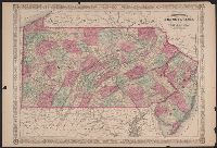
"20-21.", "Entered according to act of Congress in ... 1864 by A.J. Johnson ...", An index is included on the verso., Hand colored., Map inside decorative border., Prime meridians: Greenwich and Washington., and Relief shown by hachures.
"Entered according to Act of Congress in the Year 1864 by A.J, From Johnson's new illustrated family atlas [New York : Johnson and Ward, 1866], plates 23-24., Includes legend., Meridians: Greenwich and Washington., and Shows railroads, counties, cities and towns.
Publisher:
Johnson and Ward,
Subject (Geographic):
New England--Maps
Subject (Name):
Johnson and Ward and Johnson, A. J. (Alvin Jewett), 1827-1884. Johnson's new illustrated family atlas
Subject (Topic):
Cities and towns--New England--Maps, Counties--Connecticut--Maps, Counties--Massachusetts--Maps, Counties--New Hampshire--Maps, Counties--Rhode Island--Maps, Counties--Vermont--Maps, and Railro
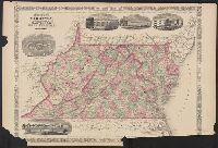
"Entered according to Act of Congress in the Year 1864, by A.J. Johnson in the Clerks Office of the District Court of the United States for the Southern District of New York." and Includes illustrations or buildings: University of Virginia--Fortress Monroe--G
Publisher:
A.J. Johnson,
Subject (Geographic):
Delaware--Maps, Maryland--Maps, Virginia--Maps, and West Virginia--Maps
Subject (Topic):
Counties--Delaware--Maps, Counties--Maryland--Maps, Counties--Virginia--Maps, Counties--West Virginia--Maps, Railroads--Delaware--Maps, Railroads--Maryland--Maps, and Railroads--West Virginia--
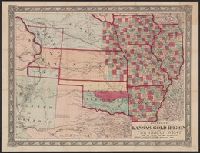
Johnson's new railroad and county copper plate map of Kansas gold region and the Great West, from the latest and best authorities, New, and New rail road and county copper plate map of Kansas gold region and the Great West, from the latest and best authorities
Description:
"Entered according to act of Congress in the year 1859 by A.J. Johnson in the clerks office of the district court of the United States for the southern district of New, Includes notes., Prime meridian: Washington., and Relief shown by hachures and spot heights.
Publisher:
Johnson & Browning,
Subject (Geographic):
Kansas--Maps and West (U.S.)--Maps
Subject (Name):
Johnson & Browning
Subject (Topic):
Colorado--Gold discoveries--Maps, Gold mines and mining--Colorado--Maps, and Railroads--West (U.S.)--Maps