Skip to search
Skip to main content
Skip to first result
Search
You Searched For
Access
Public
Format
cartographic
Language
Japanese
New Search
Search Results
Published / Created:
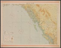
Shōwa 18 [1943] and 昭和 18 [1943]
Call Number:
739CBF 1945 1
Container / Volume:
BRBL_00391
Image Count:
1
Resource Type:
Maps, Atlases & Globes
Alternative Title:
Japan. 陸地測量部., Japan. 陸軍. 参謀本部., and ジュノー--シヤトル / 陸地測量部, 参謀本部.
Description:
"Kōkūzu gunji himitsu (senchi ni arite wa 'bugaihi' to su) ", "Sanbyakuman-bun-no-ichi Han Taih, "三百万分一汎太平洋輿地圖十六號航空圖素圖.", Publication date of 1943 infered by date for the magnetic declination information on map., and Relief shown by contours and gradient tints.
Publisher:
s.n.],
Subject (Geographic):
Alaska--Maps, British Columbia--Maps, and Washington (State)--Maps
Subject (Name):
Japan. Rikuchi Sokuryōbu and Japan. Rikugun. Sanbō Honbu
Subject (Topic):
Aeronautical charts--Alaska, Aeronautical charts--British Columbia, and Aeronautical charts--Washington (State)
Found in:
Beinecke Rare Book and Manuscript Library > Junō--Shiyatoru / Rikuchi Sokuryōbu, Sanbō Honbu.
Published / Created:
[1800?]
Call Number:
57 AT14 1800
Container / Volume:
BRBL_00303
Image Count:
1
Resource Type:
Maps, Atlases & Globes
Description:
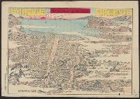
Map shows Oshima Island in the distance.
Publisher:
Yamamoto Koichi, Kansugimura, Kita-Toshimagun,
Subject (Geographic):
Atami-shi (Japan)--Maps--Early works to 1800
Found in:
Beinecke Rare Book and Manuscript Library > Kaisei Atami Shigai Zenzu. [Revised Map of the Entire City of Atami].
Creator:
Published / Created:
Taishō 12 [1923]
Call Number:
56 1923
Container / Volume:
BRBL_00296
Image Count:
1
Resource Type:
Maps, Atlases & Globes
Alternative Title:
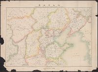
General map of northern China
Description:
"696.", "Tokyo Geographical Society 1921.", and Relief shown by hachures.
Publisher:
Tōkyō Chigaku Kyōkai,
Subject (Geographic):
China--Maps
Subject (Name):
Padley, Benjamina--Early works to 1800
Found in:
Beinecke Rare Book and Manuscript Library > Kita Shina zenzu [cartographic material] = General map of northern China.
Published / Created:
1864
Call Number:
57 K99 1864
Container / Volume:
BRBL_00303
Image Count:
2
Resource Type:
Maps, Atlases & Globes
Description:
Orig. publ. 1810.
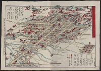
Subject (Geographic):
Kyoto (Japan)--Maps
Found in:
Beinecke Rare Book and Manuscript Library > Kyō meisho michi go-shiori nozu [Illustrated guide to the streets of Kyoto] At the head of lith: Genji Kaisei [i.e. rev 1864].
Published / Created:
1813
Call Number:
573 1813A
Container / Volume:
BRBL_00310
Image Count:
2
Resource Type:
Maps, Atlases & Globes
Publisher:
Bummendō,
Subject (Geographic):
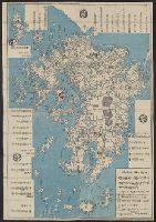
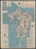
Kyūshū Region (Japan)--Maps
Found in:
Beinecke Rare Book and Manuscript Library > Kyūshū no zu [Map of Kyūshū Island, Japan].
Published / Created:
1813
Call Number:
573 1813
Container / Volume:
BRBL_00310
Image Count:
2
Resource Type:
Maps, Atlases & Globes
Publisher:
Bummendō,
Subject (Geographic):
Kyūshū Region (Japan)--Maps
Found in:
Beinecke Rare Book and Manuscript Library > Kyūshū no zu [Map of Kyūshū Island, Japan].
Published / Created:
[1846?]
Call Number:
57 N134 1846
Container / Volume:
BRBL_00304
Image Count:
1
Resource Type:
Maps, Atlases & Globes
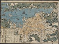
Subject (Geographic):
Japan--Maps
Found in:
Beinecke Rare Book and Manuscript Library > Map of Nagasaki.
Published / Created:
1891
Call Number:
57 N571 1891
Container / Volume:
BRBL_00304
Image Count:
1
Resource Type:
Maps, Atlases & Globes
Description:
Preliminary record.
Subject (Geographic):
Japan--Maps
Found in:
Beinecke Rare Book and Manuscript Library > Map of Niigate.
Published / Created:
[1835?]
Call Number:
58 1835
Container / Volume:
BRBL_00313
Image Count:
1
Resource Type:
Maps, Atlases & Globes
Publisher:
Chen Sung-ting, Wumen, Kiangsu,
Subject (Geographic):
East Asia--Maps
Found in:
Beinecke Rare Book and Manuscript Library > Map of the Far East.
Published / Created:
[1650]
Call Number:
11 1650B
Container / Volume:
BRBL_00003
Image Count:
2
Resource Type:
Maps, Atlases & Globes
Description:
Japanese map showing 6 most important areas: Asia, China, North and South America, Africa and Europe and Micronesia. and Preliminary record.
Subject (Geographic):
World--Maps--Early works to 1800
Found in:
Beinecke Rare Book and Manuscript Library > Map of the World.
Branch:v1.61.8 ,Deployed:2024-06-20T11:14:46-04:00