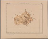
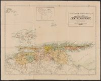
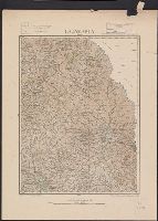
Mexico. Dirección de Estudios Geográficos y Climatológicos
Published / Created:
[1922]
Call Number:
8821 1922
Container / Volume:
BRBL_00653
Image Count:
2
Resource Type:
Maps, Atlases & Globes
Description:
"No. 2.", Accompanied by physiographic plate covering same area, showing only relief and drainage (1 sheet : col. ; 48 cm.)., Appears in Atlas geográfico de la República Mexicana., and Relief shown by shading.
Publisher:
La Dirección,
Subject (Geographic):
Aguascalientes (Mexico : State)--Maps
Subject (Name):
Mexico. Dirección de Estudios Geográficos y Climatológicos. Atlas geográfico de la República Mexicana
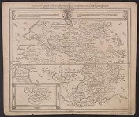
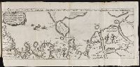
America, die newe Welt oder Inseln so hinder Hispania gegen Orient bey dem Landt Indie gelegen and Newen Inseln so hinder Hispaniam gegen Orient bey dem Landt Indie gelegen
Description:
Appeared in Münster's Cosmographia., Covers also the Pacific including New Guinea and Antarctica, i.e. Meridies terra del fuego., In the right-hand panel of text surmounting the map, the words Nova Francia appear in italic text rather than roman and the last word in the second line is Spanien., On verso: America, die newe Welt/ oder Inseln/ so hinder His-pania gegen Orient / bey dem Landt Indie gelegen. XXVI., Relief shown pictorially., Sheet measures 33.4 x 39.3 cm. Cross Collection no. 113., Text in German; place names in Latin or Spanish., and Title at top: Die newen Inseln/ so hinder Hispania gegen Orient/ bey dem Landt Indie gelegen.
Publisher:
s.n.,
Subject (Geographic):
America--Maps--Early works to 1800, Pacific Ocean--Maps--Early works to 1800, and Western Hemisphere--Maps--Early works to 1800
From Francesco Saverio Clavigero's Historia Antigua de Megico., Imperfect: torn along folds and edges, with some loss of text. Stamps on verso: The South American Exploration Fund, Yale University; Bought of F. Perez de Velasco, October, 1912., and Relief shown pictorially.
Publisher:
Publicado por el Sr. R. Ackermann en Londres y en Megico,
Subject (Geographic):
Mexico--Maps.
Subject (Name):
Clavigero, Francesco Saverio, 1731-1787. Storia antica del Messico. Spanish., Neele, Samuel John, 1758-1824, engraver., and South American Exploration Fund (Yale University) Ownership.
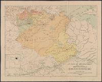
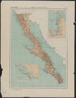
Mexico. Dirección de Estudios Geográficos y Climatológicos
Published / Created:
[1929]
Call Number:
88192 1929
Container / Volume:
BRBL_00653
Image Count:
2
Resource Type:
Maps, Atlases & Globes
Description:
"No. 3.", Accompanied by physiographic plate covering same area, showing only relief and drainage (1 sheet : col. ; 60 cm.)., Appears in Atlas geográfico de la República Mexicana., and Insets: Puerto y alrededores de La Paz. Scale 1:200,000 -- Bahia de la Magdalena y sus alrededores. Scale 1:500,000.
Publisher:
La Dirección,
Subject (Geographic):
Baja California (Mexico : Peninsula)--Maps
Subject (Name):
Mexico. Dirección de Estudios Geográficos y Climatológicos. Atlas geográfico de la República Mexicana
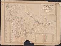
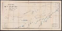
Descriptio ac delineatio geographica detectionis freti, sive, transitus ad occasum supra terras
Image Count:
1
Alternative Title:
Caerte van’t noorderste Russen, Samojeden, ende Tingoesen landt
Description:
Bound in after p. [30]., Description of Siberia by Isaac Abrahamszoon Massa., Map cut and folded irregularly., Map has multiple small ink stains on verso at the top., Printed on recto in lower right corner: D3., and Scale not given.
Subject (Geographic):
Barents Sea --Maps --Early works to 1800
Subject (Name):
Massa, Isaac, 1587-1635
Collection Created:
Amsterodami Ex officina Hesse lij Gerardi. Anno 1613