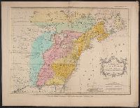
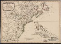
Carte des possessions angloises et françoises du continent de l'Amérique septentrionale
Description:
Appears in Palairet's Atlas methodique, 1755. Bottom margin: "On trouvera dans le troisiéme volume de la Nouvelle introduction, Copy 1: Hand col. Sheet measures 58 x 72 cm. Verso: Stamped "Yale Horace Brown 1900S"., and Matches description in Tooley.
Publisher:
Chez Mrs. Nourse, Vaillant, Millar, Rocque & Sayer ... Neaulme & Covens & Mortier ... Mr. P. Gosse,
Subject (Geographic):
France--Colonies--America--Maps--Early works to 1800, Great Britain--Colonies--America--Maps--Early works to 1800, North America--Maps--E, and United States--History--French and Indian War, 1755-1763--Maps--Early works to 1800
Subject (Name):
Cóvens et Mortier, Gosse, Pierre, 1718-1794, Kitchin, Thomas, 1718-1784, engraver, Millar, Andrew, 1707-1768, Néaulme, Jean, 1694-1780, Nourse, J. (John), -1780, and Rocque, John, -1762
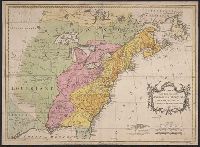
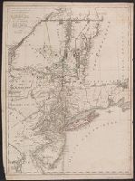
Carte des possessions angloises et françoises du continent de l'Amérique septentrionale
Description:
Appears in Palairet's Atlas methodique, 1755. Bottom margin: "On trouvera dans le troisiéme volume de la Nouvelle introduction à la géographie moderne ... "
Publisher:
Chez Mrs. Nourse, Vaillant, Millar, Rocque & Sayer ... Neaulme & Covens & Mortier ... Mr. P. Gosse,
Subject (Geographic):
France--Colonies--America--Maps--Early works to 1800, Great Britain--Colonies--America--Maps--Early works to 1800, North America--Maps--E, and United States--History--French and Indian War, 1755-1763--Maps--Early works to 1800
Subject (Name):
Cóvens et Mortier, Gosse, Pierre, 1718-1794, Kitchin, Thomas, 1718-1784, engraver, Millar, Andrew, 1707-1768, Néaulme, Jean, 1694-1780, Nourse, J. (John), -1780, and Rocque, John, -1762
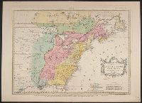
"On trouvera dans le troisiéme volume de la Nouvelle introduction à la géographie moderne ..." at bottom., Appeared in Jean Palairet's Atlas methodique., Mounted on heavy paper. On sheet 44 x 60 cm. Stamp on verso: Yale Horace Brown 1900S., Prime meridians: Ferro and London. Coordinates converted by cataloger to express longitude as measured from the Greenwich meridian., Relief shown pictorially., and Variant with "Explication" in French only.
Subject (Geographic):
France--Colonies--America--Maps--Early works to 1800., Great Britain--Colonies--America--Maps--Early works to 1800., North America--Maps--Early works to 1800., and United States--History--French and Indian War, 1755-1763--Maps--Early works to 1800.
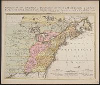
Kaart van de Engelsche en Fransche bezittingen in het vaste land van Noord America. and Possessions angloises & françoises du continet de l'Amérique septentrionale.
Description:
Based on Jean Palairet's Carte des possessions angloises françoises du continent de l'Amérique septentrionale, 1755., Hand colored., LC copy 2 accompanied by Jean Palairet's Beknopte beschr, Prime meridian: London and Île de Fer., and Relief shown pictorially.
Publisher:
Chez R. et J. Ottens, geográphes,
Subject (Geographic):
North America--Maps--Early works to 1800
Subject (Name):
Ottens, J. (Josua), 1704-1765 and Palairet, Jean, 1697-1774. Carte des possessions angloises françoises du continent de l'Amérique septentrionale
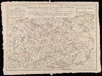
"A Paris chez l'auteur ... avec privilege 25 Mai 1719.", "Avec privilege du 30 Av. 1745"., Relief shown pictorially., Shows forests, abbeys by religious order, priories, etc., and Watermark. Sheet measures 53 x 71 cm. Verso: "100" in manuscript.
Publisher:
Ph. Buache ...
Subject (Geographic):
Catholic Church.--Province of Tours (France)--Maps--Early works to 1800., Maine (France)--Maps--Early works to 1800., and Perche (France)--Maps--Early works to 1800.
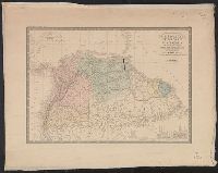
Above neat line at left: Atlas universel en 67 feuilles no. 65., Above neat line at right: No. 48., Below author: Revue par E. Levasseur membre de l'institut., and Chart at lower right shows relative elevations of mountains in each country.
Publisher:
Ch. Delagrave, 58 rue des Ecoles,
Subject (Geographic):
Amazon River--Maps, Colombia--Maps, Ecuador--Maps, Guyana--Maps, and Venezuela--Maps