Appeared in Valk and Schenk's Atlantis sylloge compendiosa, ca. 1702., Backed with paper. Ms. no. "61" in upper right-hand corner. Sheet measures 53.1 x 62.3 cm. No. 56 of 87 maps bound together., Bar scales given in "milliaria Gallica" and "milliaria Germanica.", Prime meridian: Ferro., and Relief shown pictorially.
Publisher:
Ger. et Leo. Valk,
Subject (Geographic):
Orléanais (France)--Maps--Early works to 1800.
Subject (Name):
Schenk, Peter, 1660-1718 or 1719. Atlantis sylloge compendiosa., Valck, G. (Gerard), 1651 or 1652-1726. Atlantis sylloge compendiosa., and Valck, Leonard, 1675-1746.
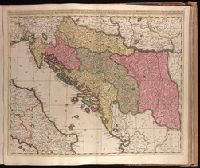
Backed with paper. Ms. no. "77" in upper right corner. Sheet measures 53.6 x 62.5 cm. No. 71 of 87 maps bound together., Bar scales given in "milliaria Hungarica" and "milliaria Germanica.", Covers Croatia, Bosnia and Hercegovina, Serbia, Montenegro and portions of Italy, Albania, Greece, Macedonia and Hungary., In Latin with place names in Italian., and Relief shown pictorially.
"R. de Hooghe f.", Appeared in Valk and Schenk's Atlantis sylloge compendiosa, ca. 1702., Backed with paper. Ms. no. "62" in lower right-hand corner. Sheet measures 53.6 x 62.8 cm. No. 57 of 87 maps bound together., Bar scales given in "milliaria Germanica" and "milliaria Gallica.", Prime meridian: Ferro., Relief shown pictorially., and Watermark.
Publisher:
By Gerard Valk op den Dam in de Wackere Hont, t'Amsterdam met privilegie van de Ed. Gr. Moog. Heeren staaten van Holl. en West Vriesland,
Subject (Geographic):
Aquitaine (France)--Maps--Early works to 1800.
Subject (Name):
Hooghe, Romeyn de, 1645-1708, engraver., Schenk, Peter, 1660-1718 or 1719. Atlantis sylloge compendiosa., Valck, G. (Gerard), 1651 or 1652-1726. Atlantis sylloge compendiosa., and Valck, Leonard, 1675-1746.