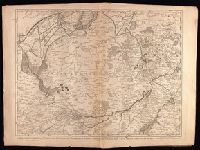
Crépy, Etienne Louis, printer Fricx, Eugène-Henri, d. 1733 Fricx, Eugène-Henri, d. 1733. Cartes des provinces des Pays Bas
Published / Created:
[1743]
Call Number:
1977 Folio 177
Image Count:
2
Resource Type:
Maps, Atlases & Globes
Description:
"No. 7" in lower right corner., Bar scales given in "echelle de deux Lieues et demie com[m]une de France" and "echelle de deux Lieues de Brabant"., From Fricx's Cartes des provinces des Pays Bas, 1744., Relief shown by hachures., Sheet measures 54.7 x 73.6 cm. No. 17 of 34 maps bound together., and Watermark.
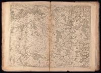
Crépy (Firm) Fricx, Eugène-Henri, d. 1733 Fricx, Eugène-Henri, d. 1733. Cartes des provinces des Pays Bas
Published / Created:
1743
Call Number:
1977 Folio 177
Image Count:
2
Resource Type:
Maps, Atlases & Globes
Description:
"No. 13" in lower right corner, outside of neat line., Bar scales given in "echelle de deux lieues et demie communes de France" and "echelle de deux lieues de Brabant"., From Fricx's Cartes des provinces des Pays Bas, 1744., Prime meridian: Ferro., Relief shown by hachures., Sheet measures 55.3 x 72.3 cm. No. 33 of 34 maps bound together., and Watermark.
Publisher:
Chez Crepy rue S. Jacques a limage S. Pierre,
Subject (Geographic):
Nord-Pas-de-Calais (France)--Maps--Early works to 1800
La Rochefoucauld-Liancourt, François-Alexandre-Frédéric, duc de, 1747-1827
Published / Created:
1799]
Call Number:
755 1799D
Container / Volume:
BRBL_00436
Image Count:
1
Resource Type:
Maps, Atlases & Globes
Description:
From La Rochefoucauld-Liancourt's Voyage dans les Etats Unis d'Amerique fait en 1795, 1796 et 1797. Paris : Chez Du Pont ... Buisson ... Charles Pougens ..., [1799], Imperfect: small hole with some loss of text. Sheet m, and Relief shown pictorially.
Publisher:
Chez Du Pont ...,
Subject (Geographic):
South Atlantic States--Maps--Early works to 1800
Subject (Name):
La Rochefoucauld-Liancourt, François-Alexandre-Frédéric, duc de, 1747-1827. Voyage dans les Etats Unis d'Amerique fait en 1795, 1796 et 1797
Panorama de l'Afrique françaises and Petit journal. Supplément illustré.
Description:
From Supplément illustré du Le Petit journal (pages 79-80; 1894?)., Includes insert maps "Environs de Tombouctou" and "Plan de Tombouctou.", and Relief shown by hachures.
Subject (Geographic):
Africa, North--Maps, Africa, West--Maps, Africa--Discovery and exploration--French--Maps, France--Colonies--Africa--Maps, and Tombouctou (Mali)--Maps
Plan du port et ville de Mahon, du Fort. St. Philippe et ses fortifications
Description:
Includes 2 insets, one showing the islands and the western part of the Mediterranean, and, "Plan du port et ville de Mahon, du Fort. St. Philippe et ses fortifications.", Relief shown by hachures., and Watermark. Manuscript number in upper right corner: 53. From the Karpinski-von Wieser Map Collection.
Publisher:
Communiquée au public par les Hertiers de Homann
Subject (Geographic):
Ibiza (Spain)--Maps--Early works to 1800., Majorca (Spain)--Maps--Early works to 1800., Minorca (Spain)--Maps--Early works to 1800., and St. Philip's Castle (Minorca)--Maps--Early works to 1800.
Subject (Name):
Dorn, Sebastian
Subject (Topic):
Fortifications--Spain--Minorca--Maps--Early works to 1800. and Harbors--Spain--Mahón--Maps--Early works to 1800.