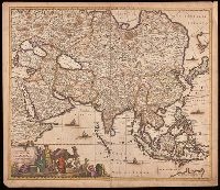
Appears in various editions of Wit's Atlas., Hand colored in outline., Imperfect: chipped and torn along edges, with no loss of text. Backed with paper., Map of Asia from Saudi Arabia, Russia, India, China, Japan to Southeast Asia., Number "4" in upper right corner., and Relief shown pictorially.
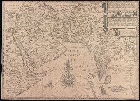
Afbeeldinge der custen van Abex, der engte van Mecha, anders ghenaempt de Roode Zee, Item de custen van Arabien, Ormus, Persen tot Sinde toe and Deliniantur in hac tabula, Orae maritimae Abexiae, freti Mecani ; al. Maris Rubri ; Arabiae, Ormi, Persiae, suprà Sindam usque Fluminis Indi, Cambaiae Indiae et Malabaris, Insulae Ceylon, Choromandeliae, et Orixae, fluvii Gangis, et Regni Bengalae, situs item Sinuum, Insularum
Description:
Backed with paper., From the author's Itinerario, voyage ofte schipvaert van Jan Huygen van Linschoten naer Oost ofte Portugaels Indien., Includes decorative cartouche and compass rose., Relief shown pictorially., and Title in Latin and Dutch. Place names in Latin and Dutch.
Publisher:
[Cornelis Claesz?],
Subject (Geographic):
Africa, Eastern--Maps--Early works to 1800., India--Maps--Early works to 1800., and Iran--Maps--Early works to 1800.
Subject (Name):
Langren, Henricus F. ab (Henricus Florentius), approximately 1574-1648. and Linschoten, Jan Huygen van, 1563-1611. Itinerario, voyage ofte schipvaert van Jan. Huygen van Linschoten naer Oost ofte Portugaels Indien.
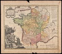
France Benedictine, ou carte generale des abbayes, & prieurez conventuels de l'Ordre de S. Benoit, tant d'hommes, que de filles, au jour a Norimberg, a 1738
Description:
Bottom left shows St. Maurice offering a book of prayers to Theodebert I, King of France who answers: "Plura Maurus precibus quam Nos Armis.", Imperfect: torn along bottom fold, with no loss of text. Watermark. Manuscript number in right corner: 19. From the Karpinski-von Wieser Map Collection., Includes note and legend., and Relief shown pictorially.
Publisher:
Recude[n]tibus Homan[n]ian. Heredib
Subject (Geographic):
France--Maps--Early works to 1800.
Subject (Name):
Homann Erben (Firm)
Subject (Topic):
Benedictine monasteries--France--Maps--Early works to 1800., Benedictine nuns--France--Maps--Early works to 1800., Convents, and Convents--France--Maps--Early works to 1800.
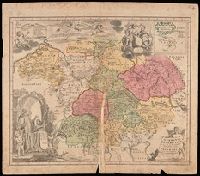
Imperfect: mutilated along fold, with some loss of text; chipped. Manuscript number in upper right corner: 4. From the Karpinski-von Wieser Map Collection., Includes illustration and inset: Appendix monasteriorum Ord. S. Bened. quae extant in Polonia et Lithuania., Relief shown pictorially., and Shows location of Benedictine monasteries in Holy Roman Empire, Poland, and Lithuania.
Publisher:
[Homann Erben]
Subject (Geographic):
Europe, Central and Germany
Subject (Topic):
Benedictine monasteries--Europe, Central--Maps--Early works to 1800, Benedictine monasteries--Germany--Maps--Early works to 1800, Monasteries--Europe, Central--Maps--Early works to 1800, and Monasteries--Germany--Maps--Early w
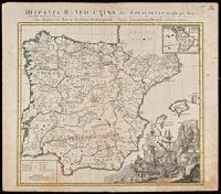
Illustrated cartouche., Includes inset: "America Benedictina"., Relief shown pictorially., and Watermark. Manuscript number "12" in upper right corner. From the Karpinski-von Wieser Map Collection.
Publisher:
Impensis Homannianorum Heredum
Subject (Geographic):
Europe--Iberian Peninsula, Iberian Peninsula--Maps--Early works to 1800., Portugal, Portugal--Maps--Early works to 1800., Spain, and Spain--Maps--Early works to 1800.
Subject (Name):
Benedictines, Benedictines--Iberian Peninsula--Maps--Early works to 1800, Benedictines--Portugal--Maps--Early works to 1800, Benedictines--Spain--Maps--Early works to 1800, Catholic C, and Catholic Church
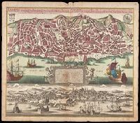
Lisabon die prächtigste Königl. Residenz Statt in Portugall u. florisanteste Handels Plaz am Austfluss des Tagi
Description:
"Cum gratia et privil. S.R.I. Vicariatus in partibus Rheni, Suevice, et Juris Franconici.", Historiated cartouche with note., Includes aerial view of "Lisabon" at bottom., and Manuscript number in upper right corner. From the Karpinski-von Wieser Map Collection.
Publisher:
[Matthaeus Seutter]
Subject (Geographic):
Lisbon (Portugal)--Aerial views--Early works to 1800, Lisbon (Portugal)--Maps--Early works to 1800, and Portugal--Lisbon
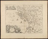
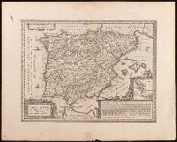
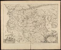
Relief shown pictorially., Verso blank., and Watermark. Manuscript number in upper left corner: 27. Manuscript annotations below neat line.
Publisher:
[Jan Jansson],
Subject (Geographic):
Albania, Albania--Maps--Early works to 1800., Europe--Macedonia, Greece--Maps--Early works to 1800., Macedonia (Republic)--Maps--Early works to 1800., and Macedonia--Maps--Early works to 1800.