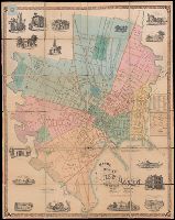
BEIN 766 N46 1859: Dissected and mounted on linen., BEIN Roll Map 485: Imperfect: mutilated, brittle, and chipped. Mounted on linen with wooden strip at top., Relief shown by hachures., "Scale 300 ft. to an inch.", Coordinates not present on map and are approximated., and Includes 15 vignettes and inset map "A plan of the town of New Haven with all the buildings in 1748."
Publisher:
Published by Eneas Smith and W.H. Rease's Lithographic Establishment, N.E. cor. 4th & Chestnut St.
BEIN Covers 59 1855: Autograph on verso: Geo. Drummond, Madras., Covers southern half of India: N 25°--N 8° and E 73°--E 86°., "Compiled and drawn by J.S. Harvey, Qr. Mr. Genls. Office, Madras"--lower left corner., and Case title: Madras Presidency.
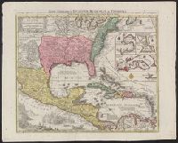
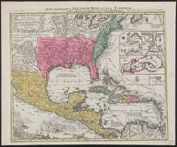
BEIN 85 1740D: Stamp on verso: Yale, Horace Brown, 1900S., BEIN 71 1737A: Forms part of the Benjamin Franklin Collection., Relief shown pictorially., "Cum gratia et privil S.R.I. Vicariatus in partibus Rheni Suevice et Juris Franconici.", Dates inferred from Portobelo inset showing "Admiralis Vernon Bachiam intrans d. 21 Novembr 1739" and reference in Lowery 328 to this map appearing as "... no. 190 in the 'Verlagsübersicht bis 1760', reprinted in Sandler's notice of Seutter.", and Includes insets of Portobelo, Havana, Cartagena, and Veracruz, text, and illustrations.
Publisher:
Tobias Conrad Seutter
Subject (Geographic):
North America, United States, Mexico, Central America, and Caribbean Area
United States. War Department. Corps of Engineers, cartographer, publisher
Published / Created:
[1881]
Call Number:
831 1881A
Image Count:
2
Resource Type:
cartographic image
Description:
Relief shown by hachures., Scale "1 inch - 12 miles.", Shows battle sites and military expeditions, with dates., Westernmost sheet: "2nd edition May 1875 compiled under direction of Capt. Wm. Ludlow, Corps of Engrs."--Lower left margin., and In upper left margin: Brig. Genl. A.A. Humphreys, Chief of Engineers.
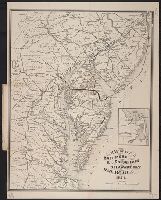
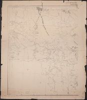
United States. War Department. Corps of Engineers, cartographer, publisher
Published / Created:
[1875?]
Call Number:
831 1875
Image Count:
1
Resource Type:
cartographic image
Description:
BEIN 831 1875: Imperfect: eastern sheet wanting; western sheet chipped. Inscription below edition statement: Lieut. [?] F. Eng., 5th Infty. Inscription on verso: Capt. Ludlow's map, 1875, sheet no. 1., Relief shown by hachures., Scale "1 inch - 12 miles.", Shows battle sites and military expeditions, with dates., and In upper left margin: Brig. Genl. A.A. Humphreys, Chief of Engineers.
Relief shown pictorially., North oriented down., Bar scale given in unidenified units., Coordinates not present on map and are approximated., Includes index of colleges, buildings, and streets., and Insets: view of Oxforde and a map of Oxfordshire with bar scale in miles.
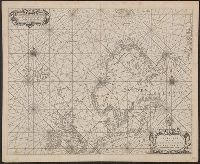
BEIN 21 1670A: Manuscript number on verso: 173. Watermark., Depths shown by isolines and soundings., Coordinates not present on map and are approximated., and From Blaeu's De groote Zee-spiegel (Amsterdam, 1655).
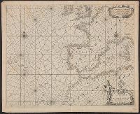
BEIN 21 1670B: Manuscript number on verso: 174. Watermark., Depths shown by isolines and soundings., Coordinates not present on map and are approximated., and From Blaeu's De groote Zee-spiegel (Amsterdam, 1655).